 Catalogue PIGMA
Assessment of ecosystem health status using MESH+, Apr. 2020
This dataset presents the resulting assessment grid (based on the EEA reference grid) with the classification of ecosystem health of the transitional, coastal and marine waters in the context of the Water Framework Directive (WFD) and the Marine Strategy Framework Directive (MSFD). This classification has been performed using the MESH+ (Marine EcoSystem Health) tool.
The MESH+ tool builds on the EEA assessment tools developed and applied in the context of assessing the degree of contamination (CHASE+), eutrophication (HEAT+) and biodiversity (BEAT+) in Europe's seas (EEA, 2018a, 2019c; Vaughan et al., 2019). MESH+ makes use of the same data sets and threshold values used in these assessments but recombines these in a new framework that addresses 'ecosystem condition'.
The overall area of interest used is based on the marine regions and subregions under the MSFD. Additionally, Norwegian (Barents Sea and Norwegian Sea) and Icelandic waters (’Iceland Sea’) have been added (see Surrounding seas of Europe). Note that within the North East Atlantic region only the subregions within EEZ boundaries (~200 nm) have been included. The spatial resolution of the assessment grid is 20 km x 20 km in coastal areas and 100 km x 100 km in offshore areas.
This dataset underpins the findings and cartographic representations published in the report "Marine Messages II" (EEA, 2020): https://www.eea.europa.eu/publications/marine-messages-2
Simple
- Date (Creation)
- 2019-05-08
- Date (Publication)
- 2020-05-14
- Edition
- 01.00
- Identifier
- eea_v_3035_20_km_mesh-ecosystem-health_p_2006-2016_v01_r00
- Identifier
- DAT-233-en
Point of contact
- Maintenance and update frequency
- As needed
- Keywords
-
- Keywords
-
- GEMET
-
- coastal water
- transitional waters
- sea water
- ocean
- marine ecosystem
- ecosystem assessment
- Water Framework Directive
- sea
- Continents, countries, sea regions of the world.
-
- Norwegian Sea
- North Sea
- Barents Sea
- English Channel
- Baltic Sea
- Bay of Biscay
- Adriatic Sea
- Black Sea
- Iceland Sea
- Aegean Sea
- Kattegat
- Mediterranean Sea
- Spatial scope
-
- European
- EEA Management Plan
-
- 2020 1.6.2
- EEA topics
-
- Chemicals
- Seas and coasts
- Water
- Biodiversity
- Pollution
- Sous-regions marines
-
- /Métropole
- /Métropole/Manche mer du Nord
- /Métropole/Mers Celtiques
- /Métropole/Golfe de Gascogne
- /Métropole/Méditerranée occidentale
- Thématiques - SIMM
-
- /Etat du Milieu/Habitats
- Thématiques - SIMM
-
- /Etat du Milieu/Pollutions
- Type de jeux de donnée - ODATIS
-
- /Données dérivées/Indicateurs
- Type de jeux de donnée - ODATIS
-
- /Données dérivées/Produits composites
- Cadre Réglementaire - SIMM
-
- Directive Cadre Stratégie pour le Milieu Marin (DCSMM)
- Cadre Réglementaire - SIMM
-
- Directive Cadre sur l'Eau (DCE)
- Access constraints
- Other restrictions
- Other constraints
- no limitations to public access
- Use constraints
- Other restrictions
- Other constraints
- License CC-BY 4.0 (https://creativecommons.org/licenses/by/4.0/). Copyright holder: European Environment Agency (EEA).
- Aggregate Datasetindentifier
- 3feffd63-ab0b-4f03-84e8-b2c324c93bbe
- Association Type
- Cross reference
- Aggregate Datasetindentifier
- 7c66cfd5-4246-4b9d-86af-624950aa49d4
- Association Type
- Cross reference
- Aggregate Datasetindentifier
- 70064384-f3b7-49ad-b137-bdf31af82158
- Association Type
- Cross reference
- Initiative Type
- Collection
- Spatial representation type
- vector Vector
- Distance
- 100 km
- Distance
- 20 km
- Metadata language
- English
- Topic category
-
- Environment
- Oceans
))
- Begin date
- 2006-01-01
- End date
- 2016-12-31
- Unique resource identifier
- EPSG:3035
- Distribution format
-
-
SHP
(
1
)
-
SHP
(
1
)
- OnLine resource
- https://sdi.eea.europa.eu/webdav/datastore/public/eea_v_3035_20_km_mesh-ecosystem-health_p_2006-2016_v01_r00/ ( EEA:FOLDERPATH )
- OnLine resource
- Direct download ( WWW:URL )
- OnLine resource
- https://marine.discomap.eea.europa.eu/arcgis/services/Marine/MESH_ecosystem_health/MapServer/WMSServer?request=GetCapabilities&service=WMS ( OGC:WMS )
- OnLine resource
-
EEA website - graphic
(
WWW:LINK-1.0-http--link
)
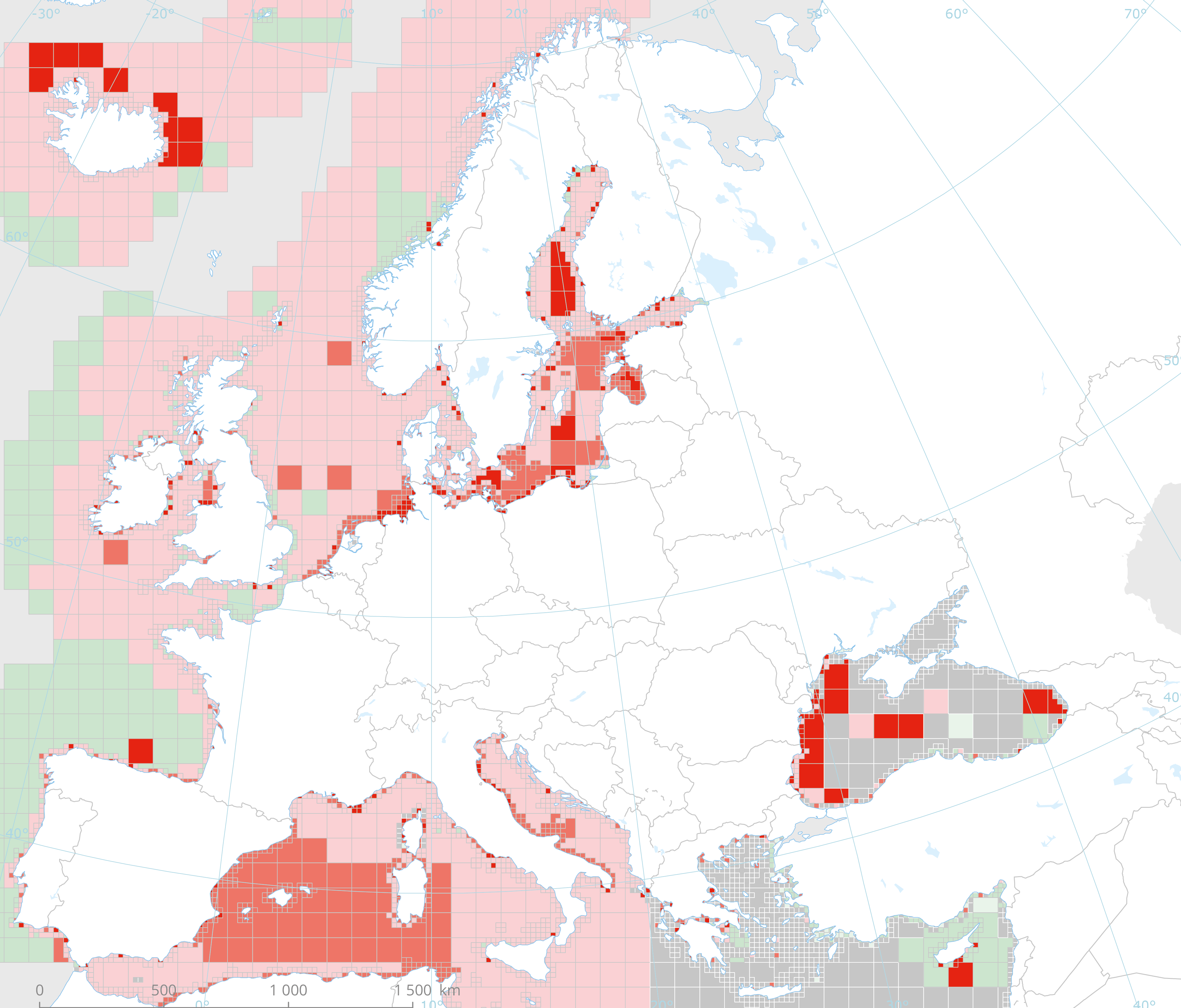
Provisional identification and mapping of ‘problem areas’ (PA) and ‘non-problem areas’ (NPA) with respect to the ‘ecosystem condition’ of Europe’s seas
- OnLine resource
- https://marine.discomap.eea.europa.eu/arcgis/rest/services/Marine/MESH_ecosystem_health/MapServer ( ESRI:REST )
- Hierarchy level
- Dataset
Domain consistency
Conformance result
- Date (Publication)
- 2010-12-08
- Explanation
- See the referenced specification
- Statement
-
Results of classification of 'Marine Ecosystem Health' using the MESH+ tool. The Ecosystem Health status is evaluated in five classes:
- "NPAhigh" and "NPAgood" are recognised as ‘non-problem areas’
- "PAmoderate", "PApoor" and "PAbad" are recognised as ‘problem areas’.
The MESH+ tool builds on the EEA assessment tools developed and applied in the context of assessing the degree of contamination (CHASE+), eutrophication (HEAT+) and biodiversity (BEAT+) in Europe's seas (EEA, 2018a, 2019c; Vaughan et al., 2019). MESH+ makes use of the same data sets and threshold values used in these assessments but recombines these in a new framework that addresses 'ecosystem condition'.
This dataset underpins the findings and cartographic representations published in the report "Marine Messages" (EEA, 2020), available on https://www.eea.europa.eu/publications/marine-messages-2/.
- File identifier
- 660a7b8e-27c0-4b94-b495-e2d6d98ddd42 XML
- Metadata language
- English
- Character set
- UTF8
- Hierarchy level
- Dataset
- Date stamp
- 2025-10-09T10:54:41.741917Z
- Metadata standard name
- ISO 19115/19139
- Metadata standard version
- 1.0
Overviews
Spatial extent
Provided by
