 Catalogue PIGMA
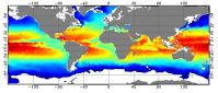
Global ARMOR3D L4 Reprocessed dataset
he Global ARMOR3D L4 Reprocessed dataset is obtained by combining satellite (Sea Level Anomalies, Geostrophic Surface Currents, Sea Surface Temperature) and in-situ (Temperature and Salinity profiles) observations through statistical methods.
References :
- ARMOR3D: Guinehut S., A.-L. Dhomps, G. Larnicol and P.-Y. Le Traon, 2012: High resolution 3D temperature and salinity fields derived from in situ and satellite observations. Ocean Sci., 8(5):845–857.
- ARMOR3D: Guinehut S., P.-Y. Le Traon, G. Larnicol and S. Philipps, 2004: Combining Argo and remote-sensing data to estimate the ocean three-dimensional temperature fields - A first approach based on simulated observations. J. Mar. Sys., 46 (1-4), 85-98.
- ARMOR3D: Mulet, S., M.-H. Rio, A. Mignot, S. Guinehut and R. Morrow, 2012: A new estimate of the global 3D geostrophic ocean circulation based on satellite data and in-situ measurements. Deep Sea Research Part II : Topical Studies in Oceanography, 77–80(0):70–81.
Simple
- Alternate title
- ARMOR3D_REP_WEEKLY
- Date (Creation)
- 2019-04-01
- Edition date
- 2020-05-27
- Identifier
- 95d99578-ee15-4ec3-9417-3c5f03e09395
- Credit
- CLS TOULOUSE
Point of contact
- Maintenance and update frequency
- Weekly
- Other
- P0M0D0H/P0M0D0H
- Maintenance note
- N/A
- Use limitation
- See Copernicus Marine Environment Monitoring Service Data commitments and licence at: https://marine.copernicus.eu/services-portfolio/service-commitments-and-licence/
- Access constraints
- Other restrictions
- Use constraints
- License
- Other constraints
- No limitations on public access
- Association Type
- Cross reference
- Initiative Type
- document
Aggregation Information
- Metadata language
- eng
- Topic category
-
- Oceans
- Description
- bounding box
))
- Begin date
- 1993-01-01
- End date
- 2018-12-31
- Reference system identifier
- EPSG / WGS 84 / Simple Mercator (EPSG:41001)
- Number of dimensions
- 2
- Dimension name
- Row
- Resolution
- 0.25 degree
- Dimension name
- Column
- Resolution
- 0.25 degree
- Cell geometry
- Area
- Transformation parameter availability
- No
- Distribution format
-
-
(
)
-
(
)
- OnLine resource
- /home/ref-cmems-public/tac/multiobs/MULTIOBS_GLO_PHY_REP_015-004/ ( NETWORK:LINK )
- OnLine resource
- https://doi.org/10.5194/os-8-845-2012 ( WWW:LINK )
- Hierarchy level
- Series
Conformance result
- Date (Publication)
- 2010-12-08
- Explanation
- See the referenced specification
- Statement
- The myOcean products depends on other products for production or validation. The detailed list of dependencies is given in ISO19115's aggregationInfo (ISO19139 Xpath = "gmd:MD_Metadata/gmd:identificationInfo/gmd:aggregationInfo[./gmd:MD_AggregateInformation/gmd:initiativeType/gmd:DS_InitiativeTypeCode/@codeListValue='upstream-validation' or 'upstream-production']")
- Attribute description
- observation
- Content type
- Physical measurement
- Descriptor
- temporal resolution: weekly mean
- Included with dataset
- No
- Feature types
- Grid
- File identifier
- 95d99578-ee15-4ec3-9417-3c5f03e09395 XML
- Metadata language
- English
- Character set
- UTF8
- Hierarchy level
- Series
- Hierarchy level name
- Copernicus Marine Service product specification
- Date stamp
- 2025-12-13T15:21:42.166807Z
- Metadata standard name
- ISO 19139, MyOcean profile
- Metadata standard version
- 0.2
Overviews
Spatial extent
Provided by
