 Catalogue PIGMA
ATLANTIC_CH07_Specification_1 / Area where bottom habitat has been disturbed by bottom trawling (number of disturbances per month)
Data from a number of different sources have been integrated to provide new perspectives on fishing activities. Vessel Monitoring Systems (VMS) record and transmit the position and speed of fishing vessels at intervals of two hours or less. Fishing time can be calculated from the VMS data and combining this parameter with vessel logbook data, maps of fishing effort and intensity at different spatial and temporal scales can be calculated. The statistical software package “R” is used to extract the required information then re-interrogated to produce maps of fishing effort or intensity per month and year. The use of Automatic Identification System (AIS) data was not considered as combining AIS data with fisheries logbook data would pose issues namely; the ability of the AIS system to be switched off, only mandatory on vessels > 15 meters in length, cost involved to purchase data, and confidentiality.
Simple
- Date (Creation)
- 2017-12-13
- Issue identification
- Not Applicable
- Purpose
- To produce map layers showing the extent of the fisheries impact on the sea floor per month
- Validation
-
- Approved
- Used by challenges
-
- Atlantic - CH07 - Fisheries Impact
- Processing level of characteristics
-
- High level analyzed
- Production mode
-
- Delayed
- GEMET - INSPIRE themes, version 1.0
-
- Sea regions
- Spatial representation type
- vector Vector
- Metadata language
- English
- Character set
- utf8 UTF8
- Topic category
-
- Oceans
N
S
E
W
))
- Begin date
- 2006
- End date
- 2016
Vertical extent
- Minimum value
- 0
- Maximum value
- 1000
- Reference system identifier
- http://www.opengis.net/def/crs/EPSG/0/4326
- Distribution format
-
-
ESRI Shapefile
()
-
ESRI Shapefile
()
- OnLine resource
-
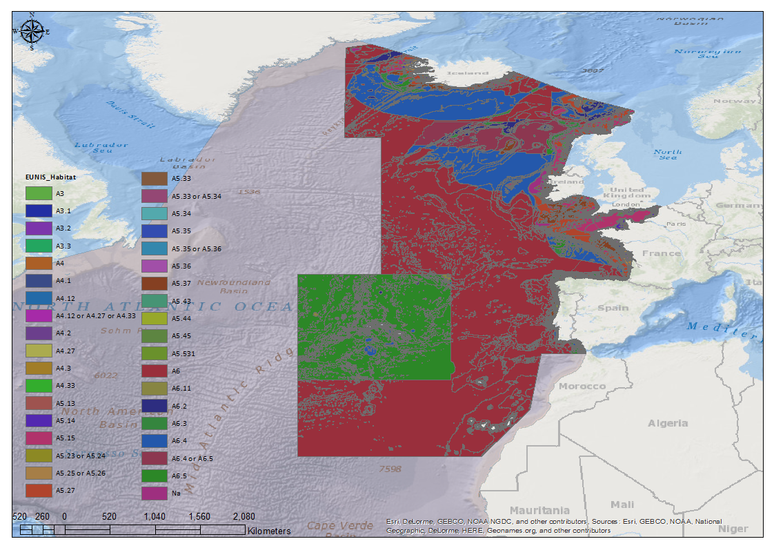
EUNIS_HAB_Map.png
(
WWW:DOWNLOAD-1.0-http--download
)
EU Habitat Classification Map
- Hierarchy level
- datasetComponent
- Other
- ATLANTIC_CH07_Product_1_1
- Other
- Fishing Effort (Vessels >15m) from VMS/Logbook data to map activity of bottom fishing (towed gears) in NE Atlantic
- Other
- Human activities|Fishing effort|Fishing_Effort_NE_Atlantic|High level analyzed|Delayed (mandatory)
N
S
E
W
))
- Begin date
- 2006
- End date
- 2017 After
Vertical extent
- Minimum value
- 0
- Maximum value
- 1000
Completeness omission
- Name of measure
- Horizontal Spatial Coverage
- Measure identification
- AP.1.1
- Measure description
- Horizontal coverage extent of product (eg : surface of the Mediterranean Sea)
Quantitative result
- Value type
- Real
- Value
- 926418
gmd:DQ_DescriptiveResult
- Date / Time
- 2018-01-30T00:00:00
- Statement
- Proportion of EU EEZ's where depth to the seafloor is equal or less than 1000m
Completeness omission
- Name of measure
- Vertical Spatial Coverage
- Measure identification
- AP.1.2
- Measure description
- Vertical coverage extent of product
Quantitative result
- Value type
- Real
- Value
- 1000
gmd:DQ_DescriptiveResult
- Date / Time
- 2018-01-30T00:00:00
- Statement
-
A ban on fishing trawling below a depth of 800 meters in the North-East Atlantic was enacted by parliament in Dec 2016 .
1000m selected to give a buffer affect
Completeness omission
- Name of measure
- Temporal Coverage
- Measure identification
- AP.1.3
- Measure description
- Temporal coverage extent of product
Quantitative result
- Value type
- Integer
- Value
- 3650
gmd:DQ_DescriptiveResult
- Date / Time
- 2018-01-30T00:00:00
- Statement
- 10 Years
Completeness omission
- Name of measure
- Number of items
- Measure identification
- AP.1.4
- Measure description
- Count of all items in the dataset or sample. Describe the items which are counted. If the number is determined by sampling unit (density), define the sampling unit (eg size of mesh).
Quantitative result
- Value type
- Integer
- Value
- 13
gmd:DQ_DescriptiveResult
- Date / Time
- 2018-01-30T00:00:00
- Statement
- EU Data Collection Framework Correspondents : Belgium, Denmark, Finland, France, Germany, Ireland, The Netherlands, Portugal, Spain, Sweden, United Kingdom, Norway, Russia
Conceptual consistency
- Name of measure
- Number of Characteristics
- Measure identification
- AP.2.1
- Measure description
- Number of characteristics in product
Quantitative result
- Value type
- Integer
- Value
- 1
gmd:DQ_DescriptiveResult
- Date / Time
- 2018-01-30T00:00:00
- Statement
- Fishing Effort
Thematic classification correctness
- Name of measure
- Horizontal resolution
- Measure identification
- AP.3.1
- Measure description
- Horizontal mesh size or equivalent value for the given scale of product (eg 50m for 1/50 000)
Quantitative result
- Value type
- Integer
- Value
- 1000
gmd:DQ_DescriptiveResult
- Date / Time
- 2018-01-30T00:00:00
- Statement
- 1000m equates to a VMS message ping every 15 min at a mean fishing speed of 2.75 kts
Thematic classification correctness
- Name of measure
- Vertical resolution
- Measure identification
- AP.3.2
- Measure description
- Average vertical sampling
Quantitative result
- Value type
- Real
gmd:DQ_DescriptiveResult
- Date / Time
- 2018-01-30T00:00:00
- Statement
- N\A
Thematic classification correctness
- Name of measure
- Temporal resolution
- Measure identification
- AP.3.3
- Measure description
- Temporal sampling interval of product
Quantitative result
- Value type
- Real
- Value
- 30
gmd:DQ_DescriptiveResult
- Date / Time
- 2018-01-30T00:00:00
- Statement
- Mean number of days in a calendar month
Quantitative attribute accuracy
- Name of measure
- Thematic accuracy
- Measure identification
- AP.3.4
- Measure description
- Percentage error of the product and description of error concept for the product (100 words max) provided by expert
Quantitative result
- Value type
- Percentage
- Statement
- N\A
Temporal validity
- Name of measure
- Temporal validity
- Measure identification
- AP.4.1
- Measure description
- Max elapsed time between last input data records update and product creation date. Minimum value 1/24 day.
Quantitative result
- Value type
- Integer
gmd:DQ_DescriptiveResult
- Date / Time
- 2018-01-30T00:00:00
- Statement
- N\A
gmd:DQ_UsabilityElement
- Name of measure
- Usability
- Measure identification
- AP.5.1
gmd:DQ_DescriptiveResult
- Date / Time
- 2018-01-30T00:00:00
- Hierarchy level
- datasetComponent
N
S
E
W
))
- Begin date
- 2006
- End date
- 2017 After
Vertical extent
- Minimum value
- 0
- Maximum value
- 1000
- Other
- ATLANTIC_CH07_Product_1_2
- Other
- Area of West African Continent ending at the NE Atlantic extent at the equator
- Other
- Human activities|Fishing effort|High Resolution VMS & ERS (Logbook) Fishing Intensity Data|High level analyzed|Delayed (mandatory)
Completeness omission
- Name of measure
- Horizontal Spatial Coverage
- Measure identification
- AP.1.1
- Measure description
- Horizontal coverage extent of product (eg : surface of the Mediterranean Sea)
Quantitative result
- Value type
- Real
- Value
- 3240183
gmd:DQ_DescriptiveResult
- Date / Time
- 2018-01-31T00:00:00
- Statement
- Spatial Extent of the African EEz's that intersect the NE Atlantic Ocean
Completeness omission
- Name of measure
- Vertical Spatial Coverage
- Measure identification
- AP.1.2
- Measure description
- Vertical coverage extent of product
Quantitative result
- Value type
- Real
- Value
- 1000
gmd:DQ_DescriptiveResult
- Date / Time
- 2018-01-31T00:00:00
- Statement
- A ban on fishing trawling below a depth of 800 meters in the North-East Atlantic was enacted by parliament in Dec 2016 . A similar ban concerning
Completeness omission
- Name of measure
- Temporal Coverage
- Measure identification
- AP.1.3
- Measure description
- Temporal coverage extent of product
Quantitative result
- Value type
- Integer
gmd:DQ_DescriptiveResult
- Date / Time
- 2018-01-31T00:00:00
- Statement
- N\A
Completeness omission
- Name of measure
- Number of items
- Measure identification
- AP.1.4
- Measure description
- Count of all items in the dataset or sample. Describe the items which are counted. If the number is determined by sampling unit (density), define the sampling unit (eg size of mesh).
Quantitative result
- Value type
- Integer
- Value
- 14
gmd:DQ_DescriptiveResult
- Date / Time
- 2018-01-31T00:00:00
- Statement
- African EEZ's : Cape Verde, Equatorial Guinea, Gambia, Ghana, Guinea, Guinea-Bissau, Ivory Coast, Liberia, Mauritania, Morocco, Sao Tome and Principe, Senegal, Sierra Leone, Western Sahara.
Conceptual consistency
- Name of measure
- Number of Characteristics
- Measure identification
- AP.2.1
- Measure description
- Number of characteristics in product
Quantitative result
- Value type
- Integer
- Value
- 1
gmd:DQ_DescriptiveResult
- Date / Time
- 2018-01-31T00:00:00
- Statement
- Spatial Extent
Thematic classification correctness
- Name of measure
- Horizontal resolution
- Measure identification
- AP.3.1
- Measure description
- Horizontal mesh size or equivalent value for the given scale of product (eg 50m for 1/50 000)
Quantitative result
- Value type
- Integer
gmd:DQ_DescriptiveResult
- Date / Time
- 2018-01-31T00:00:00
- Statement
- N\A
Thematic classification correctness
- Name of measure
- Vertical resolution
- Measure identification
- AP.3.2
- Measure description
- Average vertical sampling
Quantitative result
- Value type
- Real
gmd:DQ_DescriptiveResult
- Date / Time
- 2018-01-31T00:00:00
- Statement
- N\A
Thematic classification correctness
- Name of measure
- Temporal resolution
- Measure identification
- AP.3.3
- Measure description
- Temporal sampling interval of product
Quantitative result
- Value type
- Real
gmd:DQ_DescriptiveResult
- Date / Time
- 2018-01-31T00:00:00
- Statement
- N\A
Quantitative attribute accuracy
- Name of measure
- Thematic accuracy
- Measure identification
- AP.3.4
- Measure description
- Percentage error of the product and description of error concept for the product (100 words max) provided by expert
Quantitative result
- Value type
- Percentage
- Statement
- N\A
Temporal validity
- Name of measure
- Temporal validity
- Measure identification
- AP.4.1
- Measure description
- Max elapsed time between last input data records update and product creation date. Minimum value 1/24 day.
Quantitative result
- Value type
- Integer
gmd:DQ_DescriptiveResult
- Date / Time
- 2018-01-31T00:00:00
- Statement
- N\A
gmd:DQ_UsabilityElement
- Name of measure
- Usability
- Measure identification
- AP.5.1
gmd:DQ_DescriptiveResult
- Date / Time
- 2018-01-31T00:00:00
- Hierarchy level
- datasetComponent
N
S
E
W
))
- Begin date
- 2006
- End date
- 2017 After
Vertical extent
- Minimum value
- 0
- Maximum value
- 1000
- Other
- ATLANTIC_CH07_Product_1_3
- Other
- Area covering the Americas from Canada through the US and central America ending at the NE Atlantic extent at the equator.
- Other
- Human activities|Fishing effort|High Resolution VMS & ERS (Logbook) Fishing Intensity Data|High level analyzed|Delayed (mandatory)
Completeness omission
- Name of measure
- Horizontal Spatial Coverage
- Measure identification
- AP.1.1
- Measure description
- Horizontal coverage extent of product (eg : surface of the Mediterranean Sea)
Quantitative result
- Value type
- Real
- Value
- 17273866
gmd:DQ_DescriptiveResult
- Date / Time
- 2018-01-31T00:00:00
- Statement
- Spatial extent of the EEZ's present along the eastern seaboard of the Americas
Completeness omission
- Name of measure
- Vertical Spatial Coverage
- Measure identification
- AP.1.2
- Measure description
- Vertical coverage extent of product
Quantitative result
- Value type
- Real
- Value
- 1000
gmd:DQ_DescriptiveResult
- Date / Time
- 2018-01-31T00:00:00
Completeness omission
- Name of measure
- Temporal Coverage
- Measure identification
- AP.1.3
- Measure description
- Temporal coverage extent of product
Quantitative result
- Value type
- Integer
gmd:DQ_DescriptiveResult
- Date / Time
- 2018-01-31T00:00:00
- Statement
- N\A
Completeness omission
- Name of measure
- Number of items
- Measure identification
- AP.1.4
- Measure description
- Count of all items in the dataset or sample. Describe the items which are counted. If the number is determined by sampling unit (density), define the sampling unit (eg size of mesh).
Quantitative result
- Value type
- Integer
- Value
- 21
gmd:DQ_DescriptiveResult
- Date / Time
- 2018-01-31T00:00:00
- Statement
- Americas EEZ's : Anguilla, Antigua and Barbuda, Bahamas, Barbados,Bermuda, Brazil, British Virgin Islands, Canada, Cuba, Dominican Republic, French Guiana, Greenland, Guadeloupe,Guyana,Martinique, Puerto Rico, Suriname, Trinidad and Tobago, Turks and Caicos Islands, United States, and Venezuela. Territories below the equator are not considered.
Conceptual consistency
- Name of measure
- Number of Characteristics
- Measure identification
- AP.2.1
- Measure description
- Number of characteristics in product
Quantitative result
- Value type
- Integer
- Value
- 1
gmd:DQ_DescriptiveResult
- Date / Time
- 2018-01-31T00:00:00
- Statement
- Spatial Extent
Thematic classification correctness
- Name of measure
- Horizontal resolution
- Measure identification
- AP.3.1
- Measure description
- Horizontal mesh size or equivalent value for the given scale of product (eg 50m for 1/50 000)
Quantitative result
- Value type
- Integer
gmd:DQ_DescriptiveResult
- Date / Time
- 2018-01-31T00:00:00
- Statement
- N\A
Thematic classification correctness
- Name of measure
- Vertical resolution
- Measure identification
- AP.3.2
- Measure description
- Average vertical sampling
Quantitative result
- Value type
- Real
gmd:DQ_DescriptiveResult
- Date / Time
- 2018-01-31T00:00:00
- Statement
- N\A
Thematic classification correctness
- Name of measure
- Temporal resolution
- Measure identification
- AP.3.3
- Measure description
- Temporal sampling interval of product
Quantitative result
- Value type
- Real
gmd:DQ_DescriptiveResult
- Date / Time
- 2018-01-31T00:00:00
- Statement
- N\A
Quantitative attribute accuracy
- Name of measure
- Thematic accuracy
- Measure identification
- AP.3.4
- Measure description
- Percentage error of the product and description of error concept for the product (100 words max) provided by expert
Quantitative result
- Value type
- Percentage
- Statement
- N\A
Temporal validity
- Name of measure
- Temporal validity
- Measure identification
- AP.4.1
- Measure description
- Max elapsed time between last input data records update and product creation date. Minimum value 1/24 day.
Quantitative result
- Value type
- Integer
gmd:DQ_DescriptiveResult
- Date / Time
- 2018-01-31T00:00:00
- Statement
- N\A
gmd:DQ_UsabilityElement
- Name of measure
- Usability
- Measure identification
- AP.5.1
gmd:DQ_DescriptiveResult
- Date / Time
- 2018-01-31T00:00:00
- File identifier
- 99009eb7-4b93-4a9c-9e4d-65e5f3682956 XML
- Metadata language
- English
- Character set
- UTF8
- Hierarchy level
- Dataset
- Date stamp
- 2018-05-29T12:59:09Z
- Metadata standard name
- ISO 19115-3 - Emodnet Checkpoint - Data Product Specification
Overviews
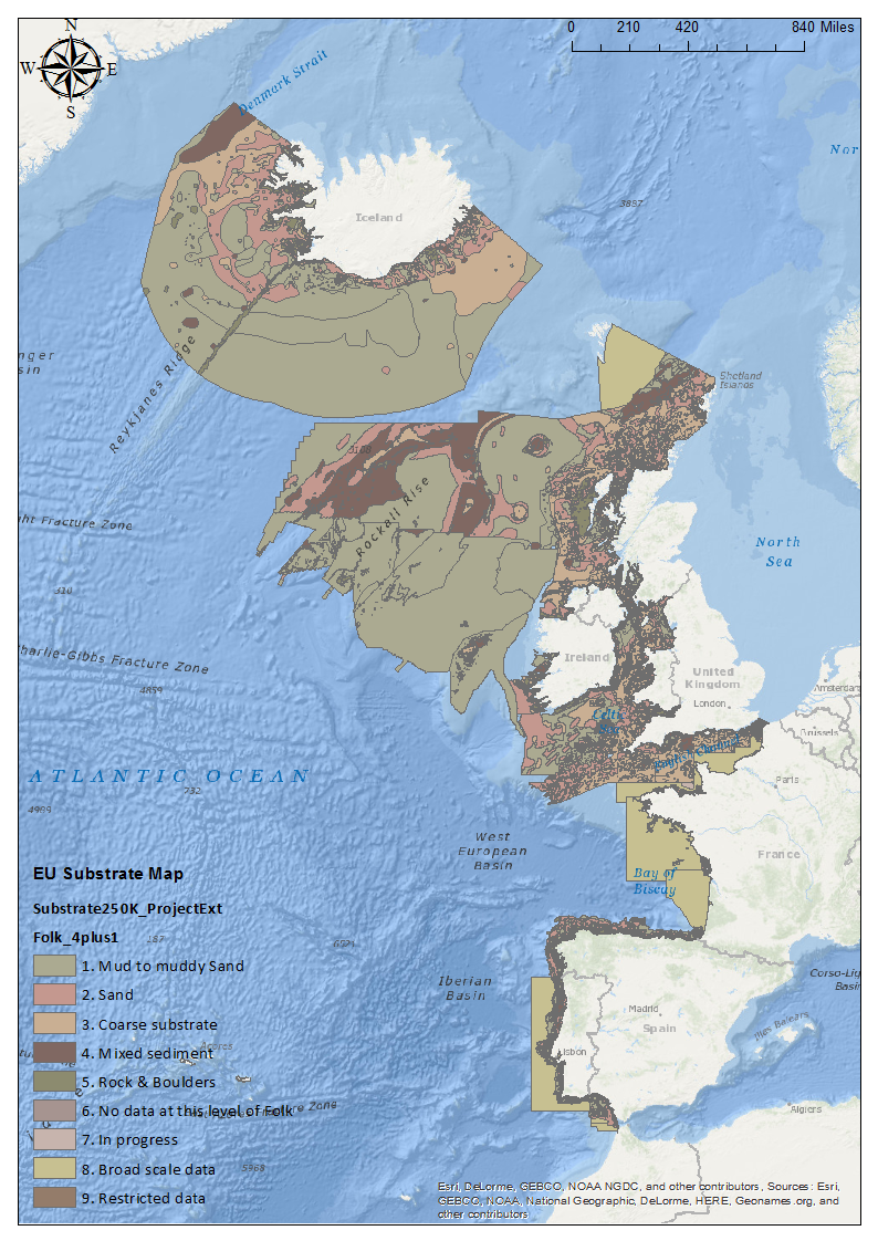
EMODnet Geology substrate 250k
Spatial extent
N
S
E
W
N
S
E
W
N
S
E
W
N
S
E
W
Provided by

Associated resources
Not available