 Catalogue PIGMA
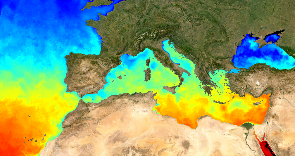
ODYSSEA Mediterranean Sea High-Resolution Sea Surface Temperature Gridded Level 4 Daily Analysis, version 3
This dataset provide a times series of daily mean fields of Sea Surface Temperature (SST) foundation at ultra-high resolution (UHR) on a 0.02 x 0.02 degree grid (approximately 2 x 2 km) for the Mediterranean Sea, every 24 hours. An Optimal interpolation (OI) technique is used to combine coincident swath measures of SST from different types satellite sensors and to fill gaps where no observations are available or obstructed by clouds. This multi-sensor compositing and interpolation process categorizes this dataset as a Level 4 product.
Whereas along swath observation data essentially represent the skin or sub-skin SST, the L4 SST product is defined to represent the SST foundation (SSTfnd). SSTfnd is defined within GHRSST-PP as the temperature at the base of the diurnal thermocline. It is so named because it represents the foundation temperature on which the diurnal thermocline develops during the day. SSTfnd changes only gradually along with the upper layer of the ocean, and by definition it is independent of skin SST fluctuations due to wind- and radiation-dependent diurnal stratification or skin layer response. It is therefore updated at intervals of 24 hrs. SSTfnd corresponds to the temperature of the upper mixed layer which is the part of the ocean represented by the top-most layer of grid cells in most numerical ocean models. It is never observed directly by satellites, but it comes closest to being detected by infrared and microwave radiometers during the night, when the previous day's diurnal stratification can be assumed to have decayed.
The processing combines the observations of multiple polar orbiting and geostationary satellites, embedding infrared of microwave radiometers. All these sources are intercalibrated with eachother before merging. The processing is the same as for the Atlantic Near Real Time (NRT) L4 dataset available on Copernicus Marine Service [SST_ATL_SST_L4_NRT_OBSERVATIONS_010_025 dataset] and users can refer to the user manual and quality documents available there for more details.
This dataset was developed in the frame of European Space Agency (ESA)'s Medspiration project.
Simple
- Date (Publication)
- 2010-08-29
- Identifier
- CER-SST-MED-1D-002-ODY-MGD / 3.0
- GEMET - INSPIRE themes, version 1.0
-
- Oceanographic geographical features
- Cersat - Parameter
-
- Ocean Temperature
- Cersat - Project
-
- GHRSST
- Medspiration
- Cersat - GCMD parameter
-
- /Ocean Temperature/Sea Surface Temperature
- Centre de données ODATIS
-
- CDS-CERSAT
- Type de jeux de donnée ODATIS
-
- /Observational data/satellite
- ODATIS aggregation parameters and Essential Variable names
-
- Sea temperature
- Specific usage
- Update
- Specific usage
- Issue
- Date (validityBegins)
- Date (validityExpires)
- Access constraints
- unrestricted
- Use constraints
- These data are produced by Ifremer/CERSAT for Medspiration project, funded by ESA.
- Other constraints
- CC-BY (Creative Commons - Attribution)
- Other constraints
- E Autret, JF Piollé, Ifremer / CERSAT. 2022. ODYSSEA Mediterranean Sea High-Resolution Sea Surface Temperature Gridded Level 4 Daily Analysis dataset (3.0) for ESA/Medspiration project. Ver. 3.0. Ifremer, Plouzane, France. Dataset accessed [YYYY-MM-DD]. DOI: 10.12770/CER-SST-MED-1D-002-ODY-MGD
- Spatial representation type
- grid Grid
- Distance
- 0.02 degree
))
- Geographic identifier
- Mediterranean Sea
- Begin date
- 2010-08-29
- Reference system identifier
- http://www.opengis.net/def/crs/EPSG/0/4326
- gmd:dimensionDescription
- Equirectangular1
- GeoreferencedParameters
- Equirectangular1
- Distribution format
-
-
NetCDF
(
4
)
-
NetCDF
(
4
)
- OnLine resource
-
OpenDAP
(
WWW:OPENDAP
)
OpenDAP
- OnLine resource
-
Local Access
(
NETWORK:LINK
)
Local path on Datarmor
- OnLine resource
- http://tds0.ifremer.fr/thredds/wms/IFREMER-MED-SST-L4-NRT-OBS_FULL_TIME_SERIE?service=WMS&version=1.3.0&request=GetCapabilities ( OGC:WMS )
- OnLine resource
-
FTP
(
WWW:FTP
)
CERSAT Public FTP
- OnLine resource
-
User guide
(
WWW:LINK
)
Product User Manual
- OnLine resource
-
Ifremer HTTP server
(
WWW:LINK
)
HTTPS
- OnLine resource
-
Ifremer THREDDS server
(
WWW:LINK
)
THREDDS
- OnLine resource
-
Processing and validation
(
WWW:LINK
)
Quality Information Document
- OnLine resource
- Syntool ( WWW:LINK )
- OnLine resource
- Digital Object Identifier (DOI) ( DOI )
- Hierarchy level
- Series
- Date / Time
- V2.0 2010-08-29
- Hierarchy level
- Dataset
- Date / Time
- V
- Hierarchy level
- Dataset
- Attribute description
- composite
- Processing level code
- L4 /
- File identifier
- CER-SST-MED-1D-002-ODY-MGD XML
- Metadata language
- English
- Character set
- UTF8
- Hierarchy level
- Series
- Date stamp
- 2024-10-15T14:59:16.505444Z
- Metadata standard name
- ISO 19115-3:2018 - Remote Sensing
Overviews
Spatial extent
Provided by
