 Catalogue PIGMA
Multi-site high resolution seabed topographical surveys (Maupiti Hoe, Niau, Socoa, Ars-en-Ré, Parlementia, Banneg)
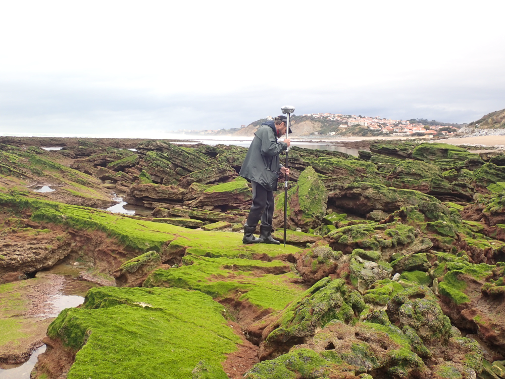
The present dataset is based on a nine site study of fine seabed topography in intertidal zones. Four coral sites (Maupiti A, B and C and Niau islands) and five rocky sites (Ars en Ré, Socoa, Parlementia A and B and Banneg island) have been explored. The data has been gathered using on-foot GNSS RTK for all sites (Trimble R8/R8S and Leica sytems) except Banneg island, where aerial Lidar data from Litto3D program has been used. The horizontal resolution varies between 3.8 and 12cm allowing to describe a wide range of spatial scales (generally over 3 spectral decades). The data has been processed to explore the statistical and spectral metrics which can be used to characterize the architectural complexity of seabeds.
Owners:
- Topographic survey on Ars-en-Ré : profile X, Z in meter along a transec was operated on 10-15 Jan 2021 with On-foot Trimble R8/R8S GNSS RTK by Shom, Gladys and Univ. de Montpellier
- Topographic survey on Maupiti Hoe: profile X, Z in meter along a transec was operated on 5-10 July 2018 with on-foot Trimble R8/R8S GNSS RTK by GLADYS and Université de Montpellier
- Topographic survey on Niau : profile X, Z in meter along a transec operated on 10 Nov. 2021 with On-foot Trimble R8/R8S GNSS RTK - by CEREGE and MIO (OSU Pytheas)
- Topographic survey on Parlementia A, and B : profile X, Z in meter along a transec was operated on 22 Fev 2023 with on-foot Leica GNSS RTK by SIAME, UPPA
- Topographic survey on Socoa : profile X, Z in meter along a transec was operated on 21 Fev 2023 with on-foot Leica GNSS RTK by SIAME, UPPA and Shom
- Topographic survey in high resolution of Banneg island (X, Y, Z) is made by aerial lidar litto3D on spring 2012/2013 by Shom and IGN
Simple
- Date (Publication)
- 2024-02-14T11:00:00
- Presentation form
- Digital model
- Presentation form
- Digital table
- Purpose
-
Le présent ensemble de données est basé sur une étude de neuf sites de topographie fine des fonds marins dans les zones intertidales. Quatre sites coralliens (Maupiti A, B et C et îles Niau) et cinq sites rocheux (Ars en Ré, Socoa, Parlementia A et B et île Banneg) ont été explorés. Les données ont été collectées à l'aide de GNSS RTK à pied pour tous les sites (systèmes Trimble R8/R8S et Leica) à l'exception de l'île de Banneg, où les données aériennes Lidar du programme Litto3D ont été utilisées. La résolution horizontale varie entre 3,8 et 12 cm permettant de décrire une large gamme d'échelles spatiales (généralement sur 3 décennies spectrales). Les données ont été traitées pour explorer les métriques statistiques et spectrales qui peuvent être utilisées pour caractériser la complexité architecturale des fonds marins.
Les collecteurs et fournisseurs des levés topographiques sont :
- pour Ars-en-Ré : le profil X, Z en mètre le long d'un transec a été opéré du 10 au 15 janvier 2021 avec On-foot Trimble R8/R8S GNSS RTK par le Shom, Gladys et l'Univ. de Montpellier
- pour Maupiti Hoe : le profil X, Z en mètre le long d'un transec a été opéré du 5 au 10 juillet 2018 avec le Trimble R8/R8S GNSS RTK à pied par GLADYS et l'Université de Montpellier
- pour Niau : le profil X, Z en mètre le long d'un transec a été opéré le 10 novembre 2021 avec le Trimble R8/R8S GNSS RTK à pied - par le CEREGE et le MIO (OSU Pytheas)
- pour Parlementia A, et B : le profil X, Z en mètre le long d'un transec a été opéré le 22 février 2023 avec le Leica GNSS RTK à pied par SIAME, UPPA
- pour Socoa : le profil X, Z en mètre le long d'un transec a été opéré le 21 février 2023 avec le Leica GNSS RTK à pied par SIAME, UPPA et Shom
- pour l'île de Banneg : le levé topographique en haute résolution (X, Y, Z) est réalisé par lidar aérien litto3D au printemps 2012/2013 par le Shom et l'IGN
- Status
- Historical archive
- Maintenance and update frequency
- Not planned
- GEMET - Concepts, version 2.4
-
- environment
- geophysical environment
- marine environment
- field experiment
- ocean
- GEMET - INSPIRE themes, version 1.0
-
- Geology
- Oceanographic geographical features
- Continents, countries, sea regions of the world.
-
- Oceania
- Bay of Biscay
- France
- French Polynesia
- Theme
-
- seabed
- topography
- roughness
- Access constraints
- Copyright
- Use constraints
- otherRestictions
- Spatial representation type
- Vector
- Denominator
- 5000
- Metadata language
- English
- Character set
- UTF8
- Topic category
-
- Oceans
- Environment
- Climatology, meteorology, atmosphere
- Geoscientific information
- Begin date
- 2012-04-01
- End date
- 2023-12-31
Extent
- Description
- Parlementia
))
- Description
- Socoa
))
- Description
- Ars-en-Ré
))
- Description
- Banneck
))
- Description
- Maupiti
))
- Description
- Niau
))
- Reference system identifier
- WGS 1984
- Distribution format
-
-
relationnal database SQL
(
1.0
)
-
relationnal database SQL
(
1.0
)
- OnLine resource
-
Digital Object Identifierr by SEANOE
(
DOI
)
Sous Damien, Meule Samuel, Michaud Heloise, Gladys group, GLADYS contact@gladys-littoral.org (2024). Multi-site high resolution seabed topographical surveys (Maupiti Hoe, Niau, Socoa, Ars-en-Ré, Parlementia, Banneg). SEANOE. https://doi.org/10.17882/98753
- OnLine resource
-
Metadata.xls
(
WWW:DOWNLOAD-1.0-http--download
)
Metadata: documentation for each topographic survey with information on filename, type (transect), units, date, methods, owner, contact, scientific program, coordinate system, latitude/longitude
- OnLine resource
-
Ars-en-Re.zip
(
WWW:DOWNLOAD-1.0-http--download
)
Ars-en-Re.zip - Topographic survey on Ars-en-Ré : profile X, Y in meter along a transec operated on 10-15 Jan 2021 with On-foot Trimble R8/R8S GNSS RTK - by Shom, Gladys and Univ. de Montpellier
- OnLine resource
-
Banneg.zip
(
WWW:DOWNLOAD-1.0-http--download
)
Banneg.zip : matrix of x, y, and z coordinates for topographic survey in high resolution of Banneg island made by aerial lidar litto3D on spring 2012/2013 by Shom and IGN
- OnLine resource
-
MaupitiHoe.zip
(
WWW:DOWNLOAD-1.0-http--download
)
MaupitiHoe.zip - Topographic survey On Maupiti Hoe: profile X, Y in meter along a transec operated on 5-10 July 2018 with on-foot Trimble R8/R8S GNSS RTK - by GLADYS and Université de Montpellier
- OnLine resource
-
Niau.zip
(
WWW:DOWNLOAD-1.0-http--download
)
Niau.zip - Topographic survey On Niau : profile X, Y in meter along a transec operated on 10 Nov. 2021 with On-foot Trimble R8/R8S GNSS RTK - by CEREGE and MIO (OSU Pytheas)
- OnLine resource
-
Parlementia.zip
(
WWW:DOWNLOAD-1.0-http--download
)
Parlementia.zip - Topographic survey on Parlementia A, and B : profile X, Y in meter along a transec operated on 22 Fev 2023 with on-foot Leica GNSS RTK - by SIAME, UPPA
- OnLine resource
-
Socoa.zip
(
WWW:DOWNLOAD-1.0-http--download
)
Socoa.zip - Topographic survey on Socoa : profile X, Y in meter along a transec operated on 21 Fev 2023 with on-foot Leica GNSS RTK - by SIAME, UPPA and Shom
- Hierarchy level
- Dataset
- Statement
-
The data may be used and redistributed for free but is not intended for legal use, since it may contain inaccuracies. Neither the data contributors (MIO, CEREGE, OSU Pytheas, SIAME, Université de Toulon, Aix-Marseille Université, Université de Montpellier, Université de Pau et des Pays d'Adour, Shom, IGN, CNRS), nor the French Government, nor any of their employees or contractors, makes any warranty, express or implied, including warranties of merchantability and fitness for a particular purpose, or assumes any legal liability for the accuracy, completeness, or usefulness, of this information.
The Banneg data has been extracted from the Litto3D database, supported by an IGN/SHOM partnership. The Maupiti data has been provided by the MAUPITI HOE 2018 experiments, fully funded by the GLADYS group. The Niau data has been retrieved with the joint support of the GLADYS group and the Direction de l'Equipement de Polynésie Française. The Ars en Ré data has been retrieved during the RICORE 2020 experiments, supported by Shom (HOMONIM project and PEA PROTEVS) and the GLADYS group. The Parlementia data has been recovered by the joint efforts of SIAME laboratory and GLADYS group. The Socoa data has been recovered in the framework of the European FEDER FSE 2014-2020 Program funding under the research project EZPONDA with GLADYS group support for instruments and human resources.
If you use these data in publications or presentation, please acknowledge MIO/Univ-Toulon, CEREGE/AMU, SIAME/UPPA, Shom, IGN and GLADYS group. Also, we would appreciate receiving a preprint and/or reprint of publications utilizing the data for inclusion in our bibliography. Relevant publications should be sent to: Damien Sous, Laboratoire MIO UMR7294, Campus de La Garde, Université de Toulon, CS 60584 - 83041 TOULON CEDEX 9 , France
- File identifier
- DSous_SeaBedTopoSurveys XML
- Metadata language
- English
- Character set
- UTF8
- Hierarchy level
- Dataset
- Hierarchy level name
- dataset
- Date stamp
- 2024-02-20T10:30:26
- Metadata standard name
- ISO 19115:2003/19139
- Metadata standard version
- 1.0
Overviews
Spatial extent
Provided by
