 Catalogue PIGMA
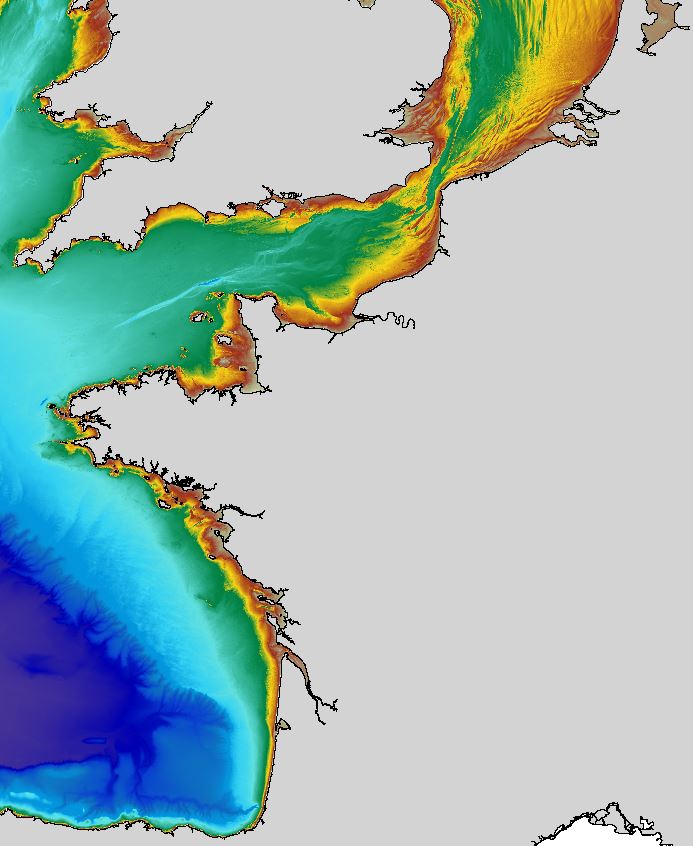
Regional bathymetric Atlantic – Channel – North-Sea DTM (100 m, HOMONIM project)
The regional bathymetric Atlantic – Channel – North-Sea DTM has a resolution of 0.001° (~111m). Its geographic coverage includes the Bay of Biscay, the English Channel and a part of the North Sea. The DTM extends from the coast to the continental slope (about of 4800m deep). This DTM is produced in the framework of the HOMONIM project which aims at improving operational forecast capabilities for the national coastal flood warning system. This DTM is offered openly on the Shom diffusion website (http://diffusion.shom.fr/produits/bathymetrie/mnt-facade-atl-homonim.html). http://dx.doi.org/10.17183/MNT_ATL100m_HOMONIM_WGS84
Simple
- Date (Creation)
- 2015-07-02
- Date (Revision)
- 2015-07-02
- Identifier
- DTM_ATL100m
Originator
Shom
+33 (0)2 56.31.25.80
http://www.shom.fr/
13, rue du Chatellier CS92803
,
BREST CEDEX 2
,
29228
,
France
+33 (0)2 56.31.23.12
+33 (0)2 56.31.25.80
http://www.shom.fr/
Custodian
Shom
+33 (0)2 56.31.25.80
http://www.shom.fr/
13, rue du Chatellier CS92803
,
BREST CEDEX 2
,
29228
,
France
+33 (0)2 56.31.23.12
+33 (0)2 56.31.25.80
http://www.shom.fr/
- Parameter Discovery Vocabulary (P02)
-
- Bathymetry and Elevation
- Vertical Datum
-
- Lowest Astronomical Tide
- Project name
-
- EMODnet HRSM
- Thèmes Sextant
-
- /Physical Environment/Bathymetry/Digital Terrain Model
- Use limitation
- Données sous Licence ouverte / Open licence : http://www.etalab.gouv.fr/pages/licence-ouverte-open-licence-5899923.html
- Access constraints
- licence
- Use constraints
- licence
- Other constraints
- Open access on the Shom diffusion website (http://diffusion.shom.fr/produits/bathymetrie/mnt-facade-atl-homonim.html), subject to acknowledgment of the source: "Shom, 2015. Regional bathymetric Atlantic – Channel – North-Sea DTM (100 m, HOMONIM project)." http://dx.doi.org/10.17183/MNT_ATL100m_HOMONIM_WGS84
- Use limitation
- Not for navigation
- Spatial representation type
- Grid
- Denominator
- 500000
- Distance
- 3.6 Arc second
- Metadata language
- English
- Character set
- UTF8
- Topic category
-
- Oceans
- Begin date
- 1816-01-01
- End date
- 2014-04-22
Vertical extent
- Minimum value
- -50
- Maximum value
- 4839
- Description
- Europe
N
S
E
W
))
- Reference system identifier
- EPSG / WGS 84 (EPSG:4326) / 7.4
- Number of dimensions
- 3
- Dimension name
- Column
- Dimension size
- 11851
- Dimension name
- Row
- Dimension size
- 9651
- Dimension name
- Time
- Dimension size
- 1
- Cell geometry
- Point
- Transformation parameter availability
- No
- Checkpoint Availability
- No
- Point in Pixel
-
- Lower left
- Distribution format
-
-
NetCDF
(
)
-
NetCDF
(
)
Distributor
Shom
+33 (0)2 98.22.05.91
http://www.shom.fr/
13, rue du Chatellier CS92803
,
BREST CEDEX 2
,
29228
,
France
+33 (0)2 98.22.05.73
+33 (0)2 98.22.05.91
http://www.shom.fr/
- Transfer size
- 447
- OnLine resource
-
DTM_ATL100m
(
WWW:LINK
)
Regional bathymetric Atlantic – Channel – North-Sea DTM (100 m, HOMONIM project)
- Hierarchy level
- Dataset
Conformance result
- Date
- Explanation
- No
- Pass
- Yes
Quantitative attribute accuracy
- Name of measure
- depth
- Measure identification
- depth accuracy
Quantitative result
- Value
- not defined
Gridded data positional accuracy
- Name of measure
- horizontal accuracy
- Measure identification
- horizontal accuracy of coordinate
Quantitative result
- Value type
- horizontal accuracy
Absolute external positional accuracy
- Name of measure
- emodnet-bathymetry.QI.Horizontal
- Value
- -1 - Multisources
Absolute external positional accuracy
- Name of measure
- emodnet-bathymetry.QI.Vertical
- Value
- -1 - Multisources
Domain consistency
- Name of measure
- emodnet-bathymetry.QI.Purpose
- Value
- 2 - Bathymetric/morphologic survey
- Hierarchy level
- Software
- Other
- software
- Hierarchy level
- Property type
- Description
- parameters of data processing
- File identifier
- SDN_CPRD_540_DTM_ATL100m XML
- Metadata language
- English
- Character set
- UTF8
- Hierarchy level name
- Composite Product Record
- Date stamp
- 2022-07-06T12:44:19.879Z
- Metadata standard name
- ISO 19115:2003/19139 - EMODNET - BATHYMETRY
- Metadata standard version
- 1.0
Author
Shom
+33 (0)2 56.31.25.80
http://www.shom.fr/
13, rue du Chatellier CS92803
,
BREST CEDEX 2
,
29228
,
France
+33 (0)2 56.31.23.12
+33 (0)2 56.31.25.80
http://www.shom.fr/
Overviews
Regional bathymetric Atlantic – Channel – North-Sea DTM (100 m, HOMONIM project)
Spatial extent
N
S
E
W
Provided by

Associated resources
Not available