 Catalogue PIGMA
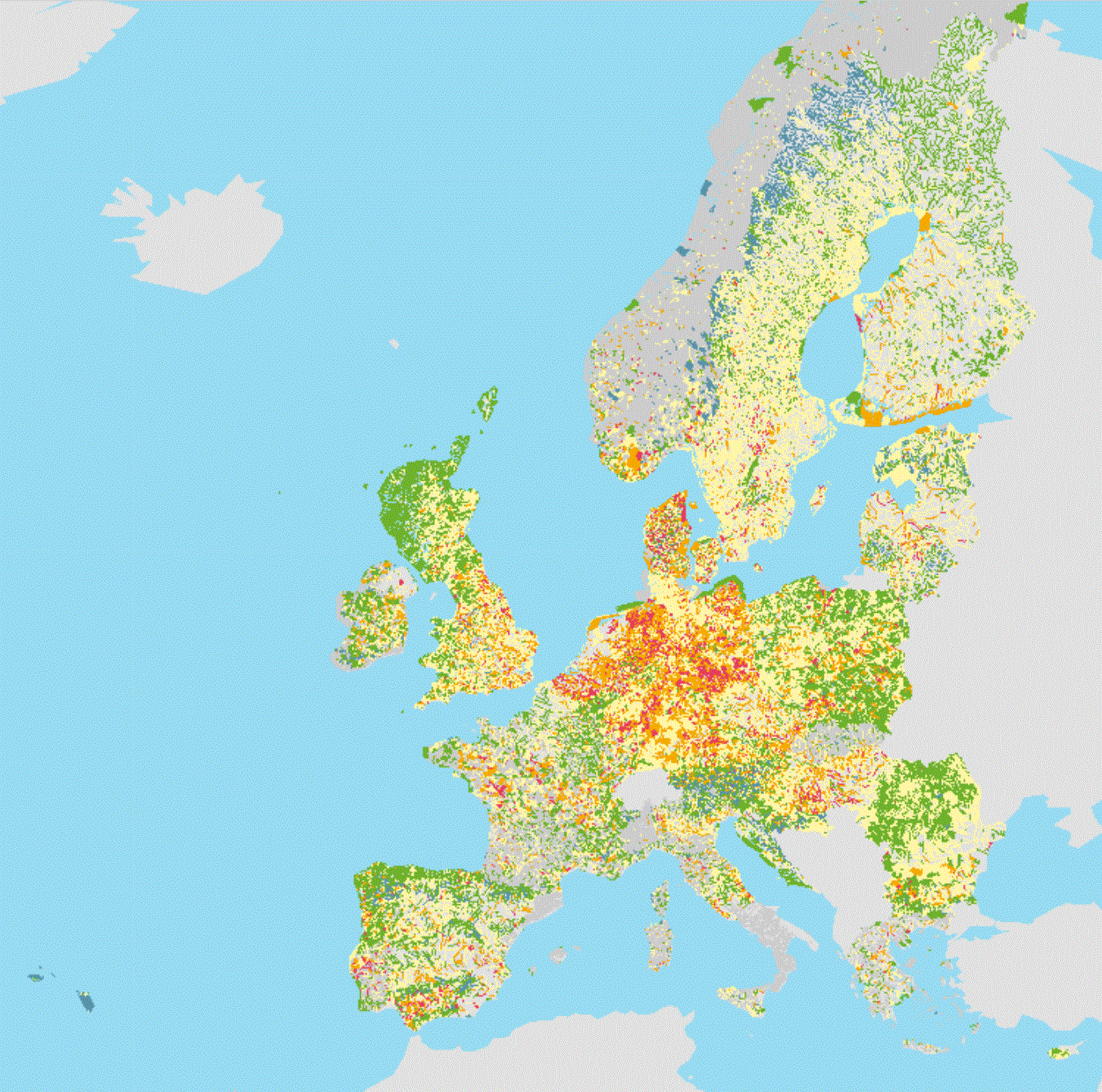
WISE WFD Quality Elements status reported under Water Framework Directive 2016
The service contains information about the ecological status or potential of European surface water bodies, delineated for the 2nd River Basin Management Plans (RBMP) under the Water Framework Directive (WFD).
The Quality Element status is the poorest of the known quality element status values per water body.
For example, the nutrient conditions status (QE3-1-6) is based on the following two quality elements: Nitrogen conditions (QE3-1-6-1) and Phosphorus conditions (QE3-1-6-2).
The ecological status or potential is presented for the following quality elements:
QE1 - Biological quality elements;
QE1-1 - Phytoplankton;
QE1-2 - Other aquatic flora;
QE1-2-1 - Macroalgae;
QE1-2-2 - Angiosperms;
QE1-2-3 - Macrophytes;
QE1-2-4 - Phytobenthos;
QE1-3 - Benthic invertebrates;
QE1-4 - Fish;
QE2 - Hydromorphological quality elements;
QE2-1 - Hydrological or tidal regime;
QE2-2 - River continuity conditions;
QE2-3 - Morphological conditions;
QE3 - Chemical and physico-chemical quality elements;
QE3-1 - General parameters;
QE3-1-1 - Transparency conditions;
QE3-1-2 - Thermal conditions;
QE3-1-3 - Oxygenation conditions;
QE3-1-4 - Salinity conditions;
QE3-1-5 - Acidification status;
QE3-1-6 - Nutrient conditions;
QE3-1-6-1 - Nitrogen conditions;
QE3-1-6-2 - Phosphorus conditions;
QE3-3 - River Basin Specific Pollutants.
The information was reported to the European Commission under the Water Framework Directive (WFD) reporting obligations.
The dataset compiles the available spatial data related to the 2nd RBMPs due in 2016 (hereafter WFD2016). See http://rod.eionet.europa.eu/obligations/715 for further information on the WFD2016 reporting.
Relevant concepts:
Surface water body: Body of surface water means a discrete and significant element of surface water such as a lake, a reservoir, a stream, river or canal, part of a stream, river or canal, a transitional water or a stretch of coastal water.
Surface water: Inland waters, except groundwater; transitional waters and coastal waters, except in respect of chemical status for which it shall also include territorial waters.
Inland water: All standing or flowing water on the surface of the land, and all groundwater on the landward side of the baseline from which the breadth of territorial waters is measured.
River: Body of inland water flowing for the most part on the surface of the land but which may flow underground for part of its course.
Lake: Body of standing inland surface water.
Transitional waters: Bodies of surface water in the vicinity of river mouths which are partly saline in character as a result of their proximity to coastal waters but which are substantially influenced by freshwater flows.
Coastal water: Surface water on the landward side of a line, every point of which is at a distance of one nautical mile on the seaward side from the nearest point of the baseline from which the breadth of territorial waters is measured, extending where appropriate up to the outer limit of transitional waters.
Simple
- Date (Publication)
- 2020-08-15
- Identifier
- eea_v_4326_250_k_wise-quality-elements-wfd2016-service
Point of contact
Point of contact
Point of contact
Point of contact
- Keywords
-
- GEMET
-
- coastal water
- ecological status
- inland water
- surface water
- water resources management
- water (geographic)
- river
- lake
- transitional waters
- water body
- water
- Water Framework Directive
- GEMET - INSPIRE themes, version 1.0
-
- Area management/restriction/regulation zones and reporting units
- Keywords
-
- Continents, countries, sea regions of the world.
-
- Italy
- Portugal
- United Kingdom
- Netherlands
- Croatia
- France
- Bulgaria
- Denmark
- Belgium
- Estonia
- Romania
- Cyprus
- Slovenia
- Spain
- Slovakia
- Czechia
- Germany
- Sweden
- Malta
- Ireland
- Latvia
- Hungary
- Greece
- Austria
- Lithuania
- Norway
- Poland
- Luxembourg
- Finland
- Spatial scope
-
- European
- INSPIRE priority data set
-
- Surface water bodies (Water Framework Directive)
- Lakes (Water Framework Directive)
- Rivers (Water Framework Directive)
- Coastal waters (Water Framework Directive)
- Transitional waters (Water Framework Directive)
- Directive 2000/60/EC
- River network (Water Framework Directive)
- Water bodies (Water Framework Directive)
- EEA topics
-
- Water
- Sous-regions marines
-
- /Métropole
- /Métropole/Manche mer du Nord
- /Métropole/Mers Celtiques
- /Métropole/Golfe de Gascogne
- /Métropole/Méditerranée occidentale
- Thématiques - SIMM
-
- /Etat du Milieu/Biogéochimie
- Thématiques - SIMM
-
- /Etat du Milieu/Espèces
- Thématiques - SIMM
-
- /Etat du Milieu/Habitats
- Thématiques - SIMM
-
- /Etat du Milieu/Hydrodynamique
- Thématiques - SIMM
-
- /Etat du Milieu/Littoral
- Type de jeux de donnée - ODATIS
-
- /Données dérivées/Produits composites
- Cadre Réglementaire - SIMM
-
- Directive Cadre sur l'Eau (DCE)
- Access constraints
- Other restrictions
- Other constraints
- no limitations to public access
- Use constraints
- Other restrictions
- Other constraints
- No limitations in the use of this web service.
- Metadata language
- English
- Character set
- utf8 UTF8
- Topic category
-
- Environment
- Inland waters
- Geoscientific information
))
- Begin date
- 2016-05-05
- End date
- 2019-03-31
- Unique resource identifier
- EPSG:4326
- Unique resource identifier
- EPSG:3857
- Unique resource identifier
- EPSG:102100
- Reference system identifier
- CRS:84
- Distribution format
-
-
ESRI REST
(
)
-
ESRI REST
(
)
- OnLine resource
- ESRI REST ( ESRI:REST )
- OnLine resource
-
OGC:WMS WFD2016_QualityElements_WM
(
OGC:WMS
)
OGC:WMS WFD2016_QualityElements_WM
- Hierarchy level
- Dataset
Domain consistency
Conformance result
- Date (Publication)
- 2013-05-21
- Explanation
- See the referenced specification
- Statement
- For more information about the lineage of the datasets provided via this web service, please consult the metadata of the associated dataset.
- File identifier
- b895b6cf-80d7-4c82-8ca4-f26a682fff0b XML
- Metadata language
- English
- Character set
- UTF8
- Hierarchy level
- Dataset
- Date stamp
- 2025-10-09T11:10:41.211736Z
- Metadata standard name
- ISO 19119/19139
- Metadata standard version
- 1.0
Overviews
Spatial extent
Provided by
