 Catalogue PIGMA
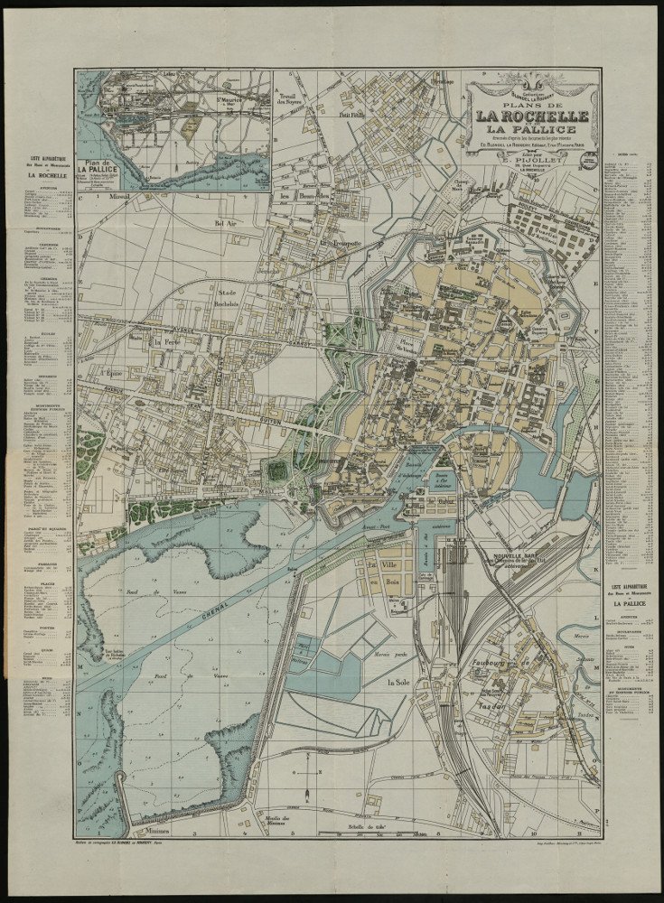
Plan de La Rochelle et de La Pallice édité en 1922_1PL936
Thème :
Date.edition : 1922
Auteur.nom :
Auteur.date :
Interêt : 1910 - 20. Densification de la Rochelle à l’extérieur de ses fortifications. Et cartouche La Pallice. Plan des rues et monuments. Plan en 4 couleurs avec liste des rues dressée d'après les documents les plus récents.
Editeur : Paris : Ed. Blondel La Rougery (Collection Blondel La Rougery)
Echelle : 1:6 000
Taille : 76x56 cm, plié 11x20 cm
Lieu d'archivage : Michel Crépeau, Patrimoine, Reserve A 1 PL 936. Exclu du prêt, consultation sur place
Numéro d'archive : Plan Carte (N° 4600160095)
Indices : 912.446 4
Référence : 1 PL 936
Simple
- Date (Creation)
- 2016-09-05
- Date (Publication)
- 2017-01-30
- Date (Revision)
- 2017-01-30
- Identifier
- FR-180-089-013-03720-LIENSs_dypomar_1_PL_936_20161229
- Credit
- LIttoral ENvironnement et Sociétés - La Rochelle Université / CNRS
- Theme
-
- La Rochelle 1920 ; La Pallice 1920
- GEMET - INSPIRE themes, version 1.0
-
- Régions maritimes
- Use limitation
- Utilisation libre sous réserve de mentionner la source (a minima le nom du producteur) et la date de sa dernière mise à jour.
- Access constraints
- Intellectual property rights
- Access constraints
- Other restrictions
- Other constraints
- Pas de restriction d’accès publique
- Classification
- Unclassified
- Spatial representation type
- grid Grid
- Denominator
- 6000
- Metadata language
- Français
- Character set
- utf8 UTF8
- Topic category
-
- Imagery base maps earth cover
- Society
- Environment
))
))
))
- Reference system identifier
- EPSG / Lambert 93 / 7.4
- Reference system identifier
- INSPIRE RS registry / grégorien
- Distribution format
-
-
GeoTIFF
(
)
-
GeoTIFF
(
)
- OnLine resource
-
pyramid_1910
(
OGC:WMS
)
pyramid_1910
- Hierarchy level
- Dataset
- Statement
-
Plans de La Rochelle et de La Pallice édité pour E. Pijollet
Plans Réf. 3 PL 936 fournie par la Médiathèque d’agglomération de La Rochelle en format numérique.
Géoréférencer le 05/09/2016 par N. Volto du LIENSs (17 points, transformation du 1er ordre, affine, avec le logiciel Arcgis (ESRI) version 10.3.1).
- File identifier
- baec0f8b-f3f8-4212-8c8a-5193fabd9322 XML
- Metadata language
- Français
- Character set
- UTF8
- Hierarchy level
- Dataset
- Hierarchy level name
- Série de données
- Date stamp
- 2025-05-15T23:54:47.32736Z
- Metadata standard name
- ISO 19115-3 - SEXTANT
- Metadata standard version
- 1.0
Overviews
Spatial extent
Provided by
