 Catalogue PIGMA
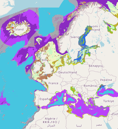
EUSeaMap (2019) Broad-Scale Predictive Habitat Map - MSFD Benthic Broad Habitat Types
Output of the 2019 EUSeaMap broad-scale predictive model, produced by EMODnet Seabed Habitats and aggregated into the Benthic Broad Habitat Types of the Marine Strategy Framework Directive (as defined in the Commission Decision 17 May 2017).
The extent of the mapped area includes the Mediterranean Sea, Black Sea, Baltic Sea, and areas of the North Eastern Atlantic extending from the Canary Islands in the south to the Barents Sea in the north.
The map was produced using a "top-down" modelling approach using classified habitat descriptors to determine a final output habitat.
Habitat descriptors differ per region but include:
- Biological zone
- Energy class
- Oxygen regime
- Salinity regime
- Seabed substrate
- Riverine input
Habitat descriptors (excepting Substrate) are calculated using underlying physical data and thresholds derived from statistical analyses or expert judgement on known conditions.
Simple
- Date (Creation)
- 2019-05-03
- Date (Publication)
- 2019-05-03
- Identifier
- fb7f3997-312d-4844-b31b-917402f4d958
- Credit
- European Marine Observation and Data Network
- Status
- completed Completed
- Thèmes Sextant
-
- /Biological Environment/Habitats
- GEMET - INSPIRE themes, version 1.0
-
- Habitats and biotopes
- Mission Atlantic - Resources
-
- Data
- Mission Atlantic - Case Studies
-
- Celtic Seas
- Mission Atlantic - BODC Parameters
-
- /Environment/Habitat
- Mission Atlantic - Data type (DMP)
-
- Spatial data products
- Mission Atlantic - Work Package
-
- WP4 Benthic Mapping
- Use limitation
- CC-BY (Creative Commons - Attribution)
- Use constraints
- Copyright
- Other constraints
- please use attribution statement included: EMODnet broad-scale seabed habitat map for Europe (v2019), licensed under CC-BY 4.0 from the European Marine Observation and Data Network (EMODnet) Seabed Habitats initiative (www.emodnet-seabedhabitats.eu), funded by the European Commission.
- Spatial representation type
- vector Vector
- Metadata language
- English
- Character set
- utf8 UTF8
- Topic category
-
- Oceans
))
- Unique resource identifier
- EPSG:4326
- Distribution format
-
-
ESRI Shapefile
(
1.0
)
-
ESRI Shapefile
(
1.0
)
- OnLine resource
- Map viewer ( WWW:LINK )
- OnLine resource
- Download data ( WWW:LINK )
- Hierarchy level
- Dataset
- Statement
-
Previous version published in 2016. This map has been updated using up-to-date input layers and extended to include the Barents Sea.
An accompanying confidence layer is available for viewing and download from EMODnet Seabed Habitats.
Details on method for the 2016 version available from: http://archimer.ifremer.fr/doc/00388/49975/ A new report is in progress.
- File identifier
- fb7f3997-312d-4844-b31b-917402f4d958 XML
- Metadata language
- English
- Character set
- UTF8
- Hierarchy level
- Dataset
- Date stamp
- 2025-05-16T09:41:05.020482Z
- Metadata standard name
- ISO 19115-3 - SEXTANT
- Metadata standard version
- 1.0
Overviews
Spatial extent
Provided by
