 Catalogue PIGMA
Assessment of contamination status using CHASE+ excluding mercury (Hg) and PBDEs, Mar. 2019
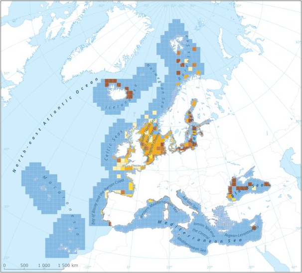
This dataset presents the resulting assessment grid (based on the EEA reference grid) with the classification of chemical status of the transitional, coastal and marine waters in the context of the Water Framework Directive (WFD) and the Marine Strategy Framework Directive (MSFD). This classification has been performed using the CHASE+ tool, with classifications of the matrices ‘water’, ‘sediment’ and ‘biota’ and indicators of ‘biological effects’, as well as an integrated classification of chemical status, combining results of all matrices. The chemical status is evaluated in five classes, where NPAhigh and NPAgood are recognised as ‘non-problem areas’ and PAmoderate, PApoor and PAbad are recognised as ‘problem areas’. This is the assessment made excluding concentrations of mercury (Hg) and polybrominated diphenyl ethers (PBDEs)
The overall area of interest used is based on the marine regions and subregions under the Marine Strategy Framework Directive. Additionally, Norwegian (Barent Sea and Norwegian Sea) and Icelandic waters (’Iceland Sea’) have been added (see Surrounding seas of Europe). Note that within the North East Atlantic region only the subregions within EEZ boundaries (~200 nm) have been included.
This dataset underpins the findings and cartographic representations published in the report "Contaminants in Europe's Seas" (EEA, 2019): https://www.eea.europa.eu/publications/contaminants-in-europes-seas.
Simple
- Date (Creation)
- 2019-03-06
- Date (Publication)
- 2019-03-21
- Edition
- 01.00
- Identifier
- eea_v_3035_20_km_chase-exclhgpbdes_p_2009-2016_v01_r00
- Identifier
- DAT-211-en
Point of contact
- Maintenance and update frequency
- As needed
- Keywords
-
- Keywords
-
- GEMET
-
- contamination
- marine biota
- environmental quality
- good chemical status
- sea
- environmentally dangerous substance
- sea water
- indicator-based assessment
- marine sediment
- Continents, countries, sea regions of the world.
-
- Iceland Sea
- Barents Sea
- Baltic Sea
- English Channel
- Adriatic Sea
- Celtic Sea
- Black Sea
- Mediterranean Sea
- Kattegat
- Bay of Biscay
- Norwegian Sea
- Aegean Sea
- Ionian Sea
- North Sea
- EEA Management Plan
-
- 2018 1.6.2
- EEA topics
-
- Chemicals
- Seas and coasts
- Water
- Biodiversity
- Pollution
- Sous-regions marines
-
- /Métropole
- /Métropole/Manche mer du Nord
- /Métropole/Mers Celtiques
- /Métropole/Golfe de Gascogne
- /Métropole/Méditerranée occidentale
- Thématiques - SIMM
-
- /Etat du Milieu/Habitats
- Thématiques - SIMM
-
- /Etat du Milieu/Pollutions
- Type de jeux de donnée - ODATIS
-
- /Données dérivées/Indicateurs
- Type de jeux de donnée - ODATIS
-
- /Données dérivées/Produits composites
- Cadre Réglementaire - SIMM
-
- Directive Cadre Stratégie pour le Milieu Marin (DCSMM)
- Cadre Réglementaire - SIMM
-
- Directive Cadre sur l'Eau (DCE)
- Use limitation
- License CC-BY 4.0 (https://creativecommons.org/licenses/by/4.0/). Copyright holder: European Environment Agency (EEA).
- Access constraints
- Other restrictions
- Other constraints
- no limitations to public access
- Aggregate Datasetindentifier
- 3feffd63-ab0b-4f03-84e8-b2c324c93bbe
- Association Type
- Cross reference
- Aggregate Datasetindentifier
- 7c66cfd5-4246-4b9d-86af-624950aa49d4
- Association Type
- Cross reference
- Spatial representation type
- vector Vector
- Distance
- 20 km
- Distance
- 100 km
- Metadata language
- English
- Topic category
-
- Environment
))
- Begin date
- 2009-01-01
- End date
- 2016-12-31
- Unique resource identifier
- EPSG:3035
- Distribution format
-
-
SHP
(
)
-
SHP
(
)
- OnLine resource
- https://sdi.eea.europa.eu/webdav/datastore/public/eea_v_3035_20_km_chase-exclhgpbdes_p_2009-2016_v01_r00/ ( EEA:FOLDERPATH )
- OnLine resource
- Direct download ( WWW:URL )
- OnLine resource
- https://water.discomap.eea.europa.eu/arcgis/rest/services/Marine/CHASE_contaminants_excluding_HG_PBDEs/MapServer ( ESRI:REST )
- Hierarchy level
- Dataset
Domain consistency
Conformance result
- Date (Publication)
- 2010-12-08
- Explanation
- See the referenced specification
- Statement
-
This assessment is based on data on contaminants, monitored in transitional, coastal and marine waters in the context of the WFD and the MSFD. The part of reported data from water, sediment and biota, as well as the information about biological effects, are derived from the DOME data portal of the International Council for the Exploration of the Sea (ICES). Other key data sources are data reported under the European Environment Information and Observation Network (Eionet), EMODnet Chemistry (the Baltic Sea and the Black Sea) and the EMBLAS project (Black Sea). In addition, France and Portugal have made new data sets available. For this analysis, Europe's seas were divided into grid cells of 20 × 20 km2 in coastal waters and 100 × 100 km2 in offshore areas. The CHASE+ methodology is a simple five-step procedure applied in every assessment unit. The five steps are: Step (1): substances/indicators are grouped into four categories (C1: water; C2: sediment; C3: biota, C4: biological effects). Step (2): for each individual substance/indicator, a contaminant ratio (CR = Cstatus/Cthreshold) is calculated. Step (3): for categories C1-3, a contamination score (CS) is calculated. Step (4): each category is subdivided into five status classes with class boundaries: 0.0-0.5 (NPAhigh), 0.5-1.0 (NPAgood), 1.0-5.0 (PAmoderate), 5.0-10.0 (PApoor) and > 10.0 (PAbad). Step (5): category-specific classifications are subsequently combined for each assessment unit into an integrated classification of 'non-problem area' (NPA) or 'problem area' (PA) by using the worst classification — the 'one-out, all-out' principle.
Based on the EEA reference grid, two grids have been developed covering the Marine Regions and Sub-regions of Europe. The first grid 100x100 km cell is used in offshore areas (> 20 km from the coastline); the second grid 20x20 km covers the coastal areas (<= 20 km from the coastline). The grid sizes were chosen after an evaluation of data availability versus the need for sufficient detail in the resulting assessment. Each cell in the grids has a unique identification defined from the lower left UTM coordinates. The CHASE+ results are associated to the unique cells in the grids.
More information can be found in the report "Contaminants in Europe's seas" and online material on https://www.eea.europa.eu/publications/contaminants-in-europes-seas/.
- File identifier
- fc018b57-05ba-4692-b96b-809983a3a983 XML
- Metadata language
- English
- Character set
- UTF8
- Hierarchy level
- Dataset
- Date stamp
- 2025-10-09T11:24:59.178684Z
- Metadata standard name
- ISO 19115/19139
- Metadata standard version
- 1.0
Overviews
Spatial extent
Provided by
