 Catalogue PIGMA
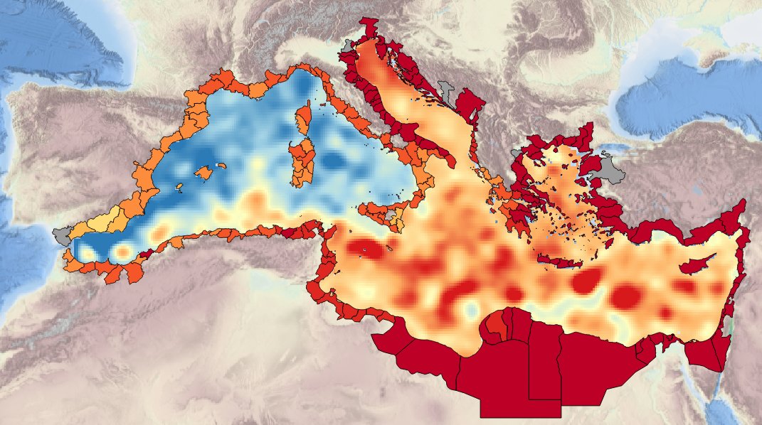
MEDSEA_CH4_Product_4 / Spatial layers of sea level trend from MyOcean-CMCC reconstruction over periods of 50 years (1963 – 2012) and 100 years (1913-2012)
Simple
- Date (Creation)
- 2016-12-16T00:00:00
- Identifier
- DOI:10.12770/07a6caf1-60c4-40e3-945a-812f725ee917
- Issue identification
- MEDSEA D5.3.5
- Purpose
- Production of spatial layers of sea level trend for the last 50 and 100 years.
- Credit
- EMODnet Medsea Checkpoint
- Used by challenges
-
- MedSea - CH04 - Climate and Coastal Protection
- Processing level of characteristics
-
- High level analyzed
- Production mode
-
- Delayed
- GEMET - INSPIRE themes, version 1.0
-
- Oceanographic geographical features
- Theme
-
- Sea-level trend
- reconstruction
- Aggregate Datasetindentifier
- b56a7b5d-6881-454a-95ea-0249acfb4823
- Association Type
- Cross reference
- Initiative Type
- specification
- Aggregate Datasetindentifier
- b67c2085-ac8f-49a1-bd90-e38e0575555d
- Association Type
- Cross reference
- Initiative Type
- upstreamData
- Spatial representation type
- vector Vector
- Metadata language
- English
- Character set
- utf8 UTF8
- Topic category
-
- Oceans
))
- Begin date
- 1913-01-01
- End date
- 2012-12-31
Vertical extent
- Minimum value
- 0
- Maximum value
- 0
- Distribution format
-
-
ESRI Shapefile
()
-
ESRI Shapefile
()
- OnLine resource
-
DOI of the product
(
WWW:LINK-1.0-http--metadata-URL
)
DOI of the product
- OnLine resource
-
CH4_product_4
(
OGC:OWS-C
)
Product visualization
- OnLine resource
-
Access to the website
(
WWW:LINK
)
Access to the website
- Hierarchy level
- datasetComponent
- Other
- MEDSEA_CH4_Product_4_1
- Other
- Basin spatial layer of sea level trend for the last 50 years
- Other
- Marine water|Sea level|Surface elevation monthly mean (unspecified datum) of the water body|Observation (raw, QC)|Delayed
- Begin date
- 1963-01-01
- End date
- 2012-12-31
Vertical extent
- Minimum value
- 0
- Maximum value
- 0
Completeness omission
- Name of measure
- Horizontal Spatial Coverage
- Measure identification
- AP.1.1
- Measure description
- Horizontal coverage extent of product (eg : surface of the Mediterranean Sea)
Quantitative result
- Value type
- Real
- Value
- 2500000
Completeness omission
- Name of measure
- Vertical Spatial Coverage
- Measure identification
- AP.1.2
- Measure description
- Vertical coverage extent of product
Quantitative result
- Value type
- Real
- Value
- 0
Completeness omission
- Name of measure
- Temporal Coverage
- Measure identification
- AP.1.3
- Measure description
- Temporal coverage extent of product
Quantitative result
- Value type
- Integer
- Value
- 18250
Conceptual consistency
- Name of measure
- Number of Characteristics
- Measure identification
- AP.2.1
- Measure description
- Number of characteristics in product
Quantitative result
- Value type
- Integer
- Value
- 1
Thematic classification correctness
- Name of measure
- Horizontal resolution
- Measure identification
- AP.3.1
- Measure description
- Horizontal mesh size or equivalent value for the given scale of product (eg 50m for 1/50 000)
Quantitative result
- Value type
- Integer
- Value
- 6250
Thematic classification correctness
- Name of measure
- Vertical resolution
- Measure identification
- AP.3.2
- Measure description
- Average vertical sampling
Quantitative result
- Value type
- Real
- Value
- 0
gmd:DQ_DescriptiveResult
- Date / Time
- 2016-12-16T00:00:00
Thematic classification correctness
- Name of measure
- Temporal resolution
- Measure identification
- AP.3.3
- Measure description
- Temporal sampling interval of product
Quantitative result
- Value type
- Real
- Value
- 0
Quantitative attribute accuracy
- Name of measure
- Thematic accuracy
- Measure identification
- AP.3.4
- Measure description
- Percentage error of the product and description of error concept for the product (100 words max) provided by expert
Quantitative result
- Value type
- Percentage
- Value
- 5
- Statement
- confidence of limit trend
Temporal validity
- Name of measure
- Temporal validity
- Measure identification
- AP.4.1
- Measure description
- Max elapsed time between last input data records update and product creation date
Quantitative result
- Value type
- Integer
- Value
- 1825
- Hierarchy level
- datasetComponent
- Other
- MEDESEA_CH4_Product_4_2
- Other
- Basin spatial layer of sea level trend for the last 100 years
- Other
- Marine water|Sea level|Surface elevation monthly mean (unspecified datum) of the water body|Observation (raw, QC)|Delayed
- Begin date
- 1913-01-01
- End date
- 2012-12-31
Vertical extent
- Minimum value
- 0
- Maximum value
- 0
Completeness omission
- Name of measure
- Horizontal Spatial Coverage
- Measure identification
- AP.1.1
- Measure description
- Horizontal coverage extent of product (eg : surface of the Mediterranean Sea)
Quantitative result
- Value type
- Real
- Value
- 2500000
Completeness omission
- Name of measure
- Vertical Spatial Coverage
- Measure identification
- AP.1.2
- Measure description
- Vertical coverage extent of product
Quantitative result
- Value type
- Real
- Value
- 0
Completeness omission
- Name of measure
- Temporal Coverage
- Measure identification
- AP.1.3
- Measure description
- Temporal coverage extent of product
Quantitative result
- Value type
- Integer
- Value
- 36500
Conceptual consistency
- Name of measure
- Number of Characteristics
- Measure identification
- AP.2.1
- Measure description
- Number of characteristics in product
Quantitative result
- Value type
- Integer
- Value
- 1
Thematic classification correctness
- Name of measure
- Horizontal resolution
- Measure identification
- AP.3.1
- Measure description
- Horizontal mesh size or equivalent value for the given scale of product (eg 50m for 1/50 000)
Quantitative result
- Value type
- Integer
- Value
- 6250
Thematic classification correctness
- Name of measure
- Vertical resolution
- Measure identification
- AP.3.2
- Measure description
- Average vertical sampling
Quantitative result
- Value type
- Real
- Value
- 0
gmd:DQ_DescriptiveResult
- Date / Time
- 2016-12-16T00:00:00
Thematic classification correctness
- Name of measure
- Temporal resolution
- Measure identification
- AP.3.3
- Measure description
- Temporal sampling interval of product
Quantitative result
- Value type
- Real
- Value
- 0
Quantitative attribute accuracy
- Name of measure
- Thematic accuracy
- Measure identification
- AP.3.4
- Measure description
- Percentage error of the product and description of error concept for the product (100 words max) provided by expert
Quantitative result
- Value type
- Percentage
- Value
- 5
- Statement
- confidence limit of the trend
Temporal validity
- Name of measure
- Temporal validity
- Measure identification
- AP.4.1
- Measure description
- Max elapsed time between last input data records update and product creation date
Quantitative result
- Value type
- Integer
- Value
- 1825
- Hierarchy level
- datasetComponent
- Other
- MEDSEA_CH4_Product_4_3
- Other
- NUTS3 regions spatial layer of sea level trend for the last 100 years
- Other
- Marine water|Sea level|Surface elevation monthly mean (unspecified datum) of the water body|Observation (raw, QC)|Delayed
- Begin date
- 1963-01-01
- End date
- 2012-12-31
Vertical extent
- Minimum value
- 0
- Maximum value
- 0
Completeness omission
- Name of measure
- Horizontal Spatial Coverage
- Measure identification
- AP.1.1
- Measure description
- Horizontal coverage extent of product (eg : surface of the Mediterranean Sea)
Quantitative result
- Value type
- Real
- Value
- 551066
Completeness omission
- Name of measure
- Vertical Spatial Coverage
- Measure identification
- AP.1.2
- Measure description
- Vertical coverage extent of product
Quantitative result
- Value type
- Real
- Value
- 0
Completeness omission
- Name of measure
- Temporal Coverage
- Measure identification
- AP.1.3
- Measure description
- Temporal coverage extent of product
Quantitative result
- Value type
- Integer
- Value
- 18250
Conceptual consistency
- Name of measure
- Number of Characteristics
- Measure identification
- AP.2.1
- Measure description
- Number of characteristics in product
Quantitative result
- Value type
- Integer
- Value
- 1
Thematic classification correctness
- Name of measure
- Horizontal resolution
- Measure identification
- AP.3.1
- Measure description
- Horizontal mesh size or equivalent value for the given scale of product (eg 50m for 1/50 000)
Quantitative result
- Value type
- Integer
- Value
- 0
Thematic classification correctness
- Name of measure
- Vertical resolution
- Measure identification
- AP.3.2
- Measure description
- Average vertical sampling
Quantitative result
- Value type
- Real
- Value
- 0
gmd:DQ_DescriptiveResult
- Date / Time
- 2016-12-16T00:00:00
Thematic classification correctness
- Name of measure
- Temporal resolution
- Measure identification
- AP.3.3
- Measure description
- Temporal sampling interval of product
Quantitative result
- Value type
- Real
- Value
- 0
Quantitative attribute accuracy
- Name of measure
- Thematic accuracy
- Measure identification
- AP.3.4
- Measure description
- Percentage error of the product and description of error concept for the product (100 words max) provided by expert
Quantitative result
- Value type
- Percentage
- Value
- 5
Temporal validity
- Name of measure
- Temporal validity
- Measure identification
- AP.4.1
- Measure description
- Max elapsed time between last input data records update and product creation date
Quantitative result
- Value type
- Integer
- Value
- 1625
- Hierarchy level
- datasetComponent
- Other
- MEDSEA_CH4_Product_4_4
- Other
- NUTS3 basin spatial layer of sea level trend for the last 100 years
- Other
- Marine water|Sea level|Surface elevation monthly mean (unspecified datum) of the water body|Observation (raw, QC)|Delayed
- Begin date
- 1913-01-01
- End date
- 2012-12-31
Vertical extent
- Minimum value
- 0
- Maximum value
- 0
Completeness omission
- Name of measure
- Horizontal Spatial Coverage
- Measure identification
- AP.1.1
- Measure description
- Horizontal coverage extent of product (eg : surface of the Mediterranean Sea)
Quantitative result
- Value type
- Real
- Value
- 551066
Completeness omission
- Name of measure
- Vertical Spatial Coverage
- Measure identification
- AP.1.2
- Measure description
- Vertical coverage extent of product
Quantitative result
- Value type
- Real
- Value
- 0
Completeness omission
- Name of measure
- Temporal Coverage
- Measure identification
- AP.1.3
- Measure description
- Temporal coverage extent of product
Quantitative result
- Value type
- Integer
- Value
- 36500
Conceptual consistency
- Name of measure
- Number of Characteristics
- Measure identification
- AP.2.1
- Measure description
- Number of characteristics in product
Quantitative result
- Value type
- Integer
- Value
- 1
Thematic classification correctness
- Name of measure
- Horizontal resolution
- Measure identification
- AP.3.1
- Measure description
- Horizontal mesh size or equivalent value for the given scale of product (eg 50m for 1/50 000)
Quantitative result
- Value type
- Integer
- Value
- 0
Thematic classification correctness
- Name of measure
- Vertical resolution
- Measure identification
- AP.3.2
- Measure description
- Average vertical sampling
Quantitative result
- Value type
- Real
- Value
- 0
gmd:DQ_DescriptiveResult
- Date / Time
- 2016-12-16T00:00:00
Thematic classification correctness
- Name of measure
- Temporal resolution
- Measure identification
- AP.3.3
- Measure description
- Temporal sampling interval of product
Quantitative result
- Value type
- Real
- Value
- 0
Quantitative attribute accuracy
- Name of measure
- Thematic accuracy
- Measure identification
- AP.3.4
- Measure description
- Percentage error of the product and description of error concept for the product (100 words max) provided by expert
Quantitative result
- Value type
- Percentage
- Value
- 5
Temporal validity
- Name of measure
- Temporal validity
- Measure identification
- AP.4.1
- Measure description
- Max elapsed time between last input data records update and product creation date
Quantitative result
- Value type
- Integer
- Value
- 1625
Completeness omission
- Name of measure
- Horizontal spatial coverage error
- Measure identification
- P.APE.1.1
- Measure description
-
Percentage to which the extent of the horizontal
spatial coverage of TPD is not compliant with the DPS extent in km**2(TDP_AP_1_1 - DPS_AP_1_1)*100/DPS_AP_1_1
Quantitative result
- Value type
- Percentage
- Value
- 0
Completeness omission
- Name of measure
- Vertical spatial coverage error
- Measure identification
- P.APE.1.2
- Measure description
-
Percentage to which the extent of the vertical spatial coverage of TPD is not compliant with the DPS extent in
metres.(TDP_AP_1_2 - DPS_AP_1_2)*100/DPS_AP_1_2
Quantitative result
- Value type
- Percentage
Completeness omission
- Name of measure
- Temporal coverage error
- Measure identification
- P.APE.1.3
- Measure description
-
Percentage to which the extent of the temporal coverage of TPD is not compliant with the DPS extent in
days.(TDP_AP_1_3 - DPS_AP_1_3)*100/DPS_AP_1_3
Quantitative result
- Value type
- Percentage
- Value
- 0
Conceptual consistency
- Name of measure
- Thematic content error
- Measure identification
- P.APE.2.1
- Measure description
-
Percentage
of completeness/Incompleteness of the number of characteristcs with respect to the list in DPS(TDP_AP_2_1 - DPS_AP_2_1)*100/DPS_AP_2_1
Quantitative result
- Value type
- Percentage
- Value
- 0
Thematic classification correctness
- Name of measure
- Horizontal resolution error
- Measure identification
- P.APE.3.1
- Measure description
-
Percentage to which the product averaged horizontal mesh size or horizontal scale is not compliant with the DPS
averaged mesh size or horizontal scale(DPS_AP_3_1 - TDP_AP_3_1)*100/DPS_AP_3_1
Quantitative result
- Value type
- Percentage
- Value
- -108.33333333333333
Thematic classification correctness
- Name of measure
- Vertical resolution error
- Measure identification
- P.APE.3.2
- Measure description
-
Percentage to which the product averaged vertical mesh size or vertical scale is not compliant with the DPS
averaged mesh size or vertical scale(DPS_AP_3_2 - TDP_AP_3_2)*100/DPS_AP_3_2
Quantitative result
- Value type
- Percentage
Thematic classification correctness
- Name of measure
- Temporal sampling interval error
- Measure identification
- P.APE.3.3
- Measure description
-
Percentage to which the product temporal sampling interval is not compliant with the one defined in DPS
(percentage to be extracted from text of AP.3.3 measure)(DPS_AP_3_3 - TDP_AP_3_3)*100/DPS_AP_3_3
Quantitative result
- Value type
- Percentage
Quantitative attribute accuracy
- Name of measure
- Thematic accuracy errror
- Measure identification
- P.APE.3.4
- Measure description
-
Compliance with the value domain of
the accuracy defined in DPS (% extracted from thematic accuracy description)TDP_AP_3_4
Quantitative result
- Value type
- Percentage
- Value
- 5
Temporal validity
- Name of measure
- Temporal validity error
- Measure identification
- P.APE.4.1
- Measure description
-
Percentage to which the elapsed time of the product is not compliant with the max elapsed time specified in
DPS.(DPS_AP_4_1 - TDP_AP_4_1)*100/DPS_AP_4_1
Quantitative result
- Value type
- Percentage
- Value
- 0
Completeness omission
- Name of measure
- Horizontal spatial coverage error
- Measure identification
- P.APE.1.1
- Measure description
-
Percentage to which the extent of the horizontal
spatial coverage of TPD is not compliant with the DPS extent in km**2(TDP_AP_1_1 - DPS_AP_1_1)*100/DPS_AP_1_1
Quantitative result
- Value type
- Percentage
- Value
- -0.387376199591836
Completeness omission
- Name of measure
- Vertical spatial coverage error
- Measure identification
- P.APE.1.2
- Measure description
-
Percentage to which the extent of the vertical spatial coverage of TPD is not compliant with the DPS extent in
metres.(TDP_AP_1_2 - DPS_AP_1_2)*100/DPS_AP_1_2
Quantitative result
- Value type
- Percentage
Completeness omission
- Name of measure
- Temporal coverage error
- Measure identification
- P.APE.1.3
- Measure description
-
Percentage to which the extent of the temporal coverage of TPD is not compliant with the DPS extent in
days.(TDP_AP_1_3 - DPS_AP_1_3)*100/DPS_AP_1_3
Quantitative result
- Value type
- Percentage
- Value
- 0
Conceptual consistency
- Name of measure
- Thematic content error
- Measure identification
- P.APE.2.1
- Measure description
-
Percentage
of completeness/Incompleteness of the number of characteristcs with respect to the list in DPS(TDP_AP_2_1 - DPS_AP_2_1)*100/DPS_AP_2_1
Quantitative result
- Value type
- Percentage
- Value
- 0
Thematic classification correctness
- Name of measure
- Horizontal resolution error
- Measure identification
- P.APE.3.1
- Measure description
-
Percentage to which the product averaged horizontal mesh size or horizontal scale is not compliant with the DPS
averaged mesh size or horizontal scale(DPS_AP_3_1 - TDP_AP_3_1)*100/DPS_AP_3_1
Quantitative result
- Value type
- Percentage
Thematic classification correctness
- Name of measure
- Vertical resolution error
- Measure identification
- P.APE.3.2
- Measure description
-
Percentage to which the product averaged vertical mesh size or vertical scale is not compliant with the DPS
averaged mesh size or vertical scale(DPS_AP_3_2 - TDP_AP_3_2)*100/DPS_AP_3_2
Quantitative result
- Value type
- Percentage
Thematic classification correctness
- Name of measure
- Temporal sampling interval error
- Measure identification
- P.APE.3.3
- Measure description
-
Percentage to which the product temporal sampling interval is not compliant with the one defined in DPS
(percentage to be extracted from text of AP.3.3 measure)(DPS_AP_3_3 - TDP_AP_3_3)*100/DPS_AP_3_3
Quantitative result
- Value type
- Percentage
Quantitative attribute accuracy
- Name of measure
- Thematic accuracy errror
- Measure identification
- P.APE.3.4
- Measure description
-
Compliance with the value domain of
the accuracy defined in DPS (% extracted from thematic accuracy description)TDP_AP_3_4
Quantitative result
- Value type
- Percentage
- Value
- 5
Temporal validity
- Name of measure
- Temporal validity error
- Measure identification
- P.APE.4.1
- Measure description
-
Percentage to which the elapsed time of the product is not compliant with the max elapsed time specified in
DPS.(DPS_AP_4_1 - TDP_AP_4_1)*100/DPS_AP_4_1
Quantitative result
- Value type
- Percentage
- Value
- 0
- File identifier
- 07a6caf1-60c4-40e3-945a-812f725ee917 XML
- Metadata language
- English
- Character set
- UTF8
- Hierarchy level
- Dataset
- Date stamp
- 2025-01-28T09:16:25.11999Z
- Metadata standard name
- ISO 19115-3 - Emodnet Checkpoint - Targeted Data Product
Overviews
Spatial extent
Provided by
