 Catalogue PIGMA
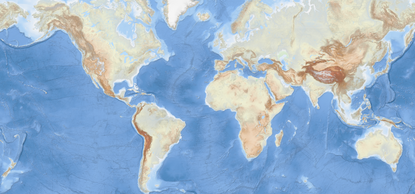
EMODNET Bathymetry World Base Layer version 1
The EMODnet Bathymetry World Base Layer (EBWB) service is a gridded representation of worldwide bathymetric and topographic coverage adapted for a better representation of seabed morphological features. Based on modern WMTS schema, it allows a fluid and powerful rendering.
For the global oceans EBWB1 is composed of the 2018 EMODnet Bathymetric grid around Europe (approx. 100m resolution) and uses the GEBCO 2019 grid (approx. 500m resolution) elsewhere in the marine environment. Land coverage is based on a combination of 30 arc second ASTER GDEM, SRTM3, EU-DEM, and Global 1 second world-wide water body map for the topographic part. This compilation of publicly available data sources have been merged and pre-tiled for rendering, at 10 levels of zoom starting from 1/24th of an arcminute (approx. 75m resolution). The EBWB1 service is available in non-projected system (Lat, Long, WGS84: EPSG:4086), Web Mercator (EPSG:3857), Inspire compliant ETRS-EALA projection (EPSG:3035) and projections adapted to both poles (ESPG 3031 and 3996)
Service URL:
https://tiles.emodnet-bathymetry.eu/wmts/1.0.0/WMTSCapabilities.xml
Simple
- Date (Publication)
- 2024-04-15
- Identifier
- EMODnet_Bathymetry_World_Base_Layer_v1
- Thèmes Sextant
-
- /Physical Environment/Bathymetry/Digital Terrain Model
- GEMET - INSPIRE themes, version 1.0
-
- Elevation
- Access constraints
- Creative Commons Attribution 4.0 International
- Use constraints
- Other restrictions
- Other constraints
- DO NOT USE FOR NAVIGATION
- Spatial representation type
- vector Vector
- Metadata language
- English
- Character set
- utf8 UTF8
- Topic category
-
- Oceans
- Elevation
))
- Distribution format
-
-
(
)
-
(
)
- OnLine resource
- EMODnet Bathymetry WMTS service ( WWW:LINK )
- OnLine resource
- EMODnet viewer ( WWW:LINK )
- OnLine resource
- Digital Object Identifier (DOI) ( DOI )
- Hierarchy level
- Dataset
Domain consistency
Conformance result
- Date (Publication)
- 2010-12-08
- Explanation
- See the referenced specification
- Statement
-
DATA SOURCES for the EMODnet Bathymetry World Base Layer version 1 (EBWB1).
The EMODnet Bathymetry World Base Layer version 1 is an extension to the EMODnet Bathymetry viewing service and is provided to the public domain to support applications that cross European borders. Within the EMODnet area (45W,90N to 36E,15N) EBWB1 is identical to the EMODnet Bathymetry release 2018 with a source resolution of 1/16 of an arc minute. Terms of use and source reference information are available at https://emodnet.ec.europa.eu/en/bathymetry#bathymetry-products. Outside the EMODnet area the following data sources have been used for the compilation of EBWB1:
GEBCO
All bathymetric data outside of the EMODnet area (45W,90N to 36E,15N) is derived from the GEBCO 2019 Grid. This grid is available from https://www.gebco.net/. GEBCO’s gridded bathymetric data set (the GEBCO_2019 grid) is a global terrain model for ocean and land at 15 arc-second intervals. To enhance the viewing experience for the EMODnet World Base Layer the GEBCO 2019 grid has been resampled to 3 arc seconds before combining with land-based world elevation data. The following policy and restrictions apply to the GEBCO_2019 grid:
Scope
• These terms of use apply to The GEBCO Grid and other GEBCO-derived information products.
• For brevity 'The GEBCO Grid' is used throughout and should be interpreted as meaning The GEBCO Grid and other GEBCO-derived information products.
• Bathymetric Data refers to measurements made by various instruments of the ocean depth, associated ocean properties and the supporting metadata.
• Information products are the result of applying algorithms, mathematical techniques, scientific theory and Intellectual Property to data to create useful, derived values.
• As The GEBCO Grid is created by interpolating, applying algorithms and mathematical techniques to bathymetric data, GEBCO considers the GEBCO Grid to be an information product.
• GEBCO does not provide the underlying source bathymetric data when distributing The GEBCO Grid.
Terms of use
The GEBCO Grid is placed in the public domain and may be used free of charge.
Use of the GEBCO Grid indicates that the user accepts the conditions of use and disclaimer information given below.
Users are free to:
• Copy, publish, distribute and transmit The GEBCO Grid.
• Adapt The GEBCO Grid.
• Commercially exploit The GEBCO Grid, by, for example, combining it with other information, or by including it in their own product or application.
Users must:
• Acknowledge the source of The GEBCO Grid. A suitable form of attribution is given in the documentation that accompanies The GEBCO Grid.
• Not use The GEBCO Grid in a way that suggests any official status or that GEBCO, or the IHO or IOC, endorses any particular application of The GEBCO Grid.
• Not mislead others or misrepresent The GEBCO Grid or its source.
Disclaimer
• The GEBCO Grid should NOT be used for navigation or for any other purpose involving safety at sea.
• The GEBCO Grid is made available 'as is'. While every effort has been made to ensure reliability within the limits of present knowledge, the accuracy and completeness of The GEBCO Grid cannot be guaranteed. No responsibility can be accepted by GEBCO, IHO, IOC, or those involved in its creation or publication for any consequential loss, injury or damage arising from its use or for determining the fitness of The GEBCO Grid for any particular use.
• The GEBCO Grid is based on bathymetric data from many different sources of varying quality and coverage.
• As The GEBCO Grid is an information product created by interpolation of measured data, the resolution of The GEBCO Grid may be significantly different to that of the resolution of the underlying measured data.
World elevation data
Various sources have been used for world elevation data used for visualization of the land data in the EMODnet Bathymetry viewing service. The land data shown as part of the EMODnet World Base Layer is only available as viewing service and not available for download. The purpose of the land data shown is to provide a complementary image of the world elevation. Collecting and maintaining land elevation data as such is not part of the EMODnet mission.
The elevation data used provides height above the sea level in meters for every single place in the world, measured for regions of approximately 90x90 meters.
The original raw open data from US Geological Survey (SRTM 3 ), NASA and METI (ASTER GDEM), European Union (EU-DEM) and other sources has been modified, adapted and overlaid to "fill the gaps" and provide a seamless and directly reusable global digital elevation model. This work is done by Jonathan de Ferranti BA and made available through his website http://viewfinderpanoramas.org/.
The following data citation and redistribution policies apply to the underlying raw data:
SRTM3 and ASTER
Data Access
All data products distributed by NASA's Land Processes Distributed Active Archive Center (LP DAAC) are available at no charge.
Data Redistribution
All LP DAAC current data and products acquired through the LP DAAC have no restrictions on reuse, sale, or redistribution.
ASTER GDEM Version 3 (ASTGTM V003) was released on August, 5, 2019 and contains no redistribution requirements. The LP DAAC kindly requests that you properly cite the data in your research. Pre-populated citations for the product can be found on the DOI Landing Page for the product under the "Citation" section. Users are encouraged to use ASTER GDEM Version 3 going forward as ASTER GDEM Version 2 data are no longer available from the LP DAAC.
Previously ASTER GDEM Version 2 (ASTGTM V002) data required users to agree to only redistribute data products to individuals within their organization or project of intended use, or in response to disasters in support of the GEO Disaster Theme prior to downloading data. In addition, the following sentence was required to be included in publications that used the data: "ASTER GDEM is a product of Japan’s Ministry of Economy, Trade, and Industry (METI) and NASA." Projects that are continuing to use ASTER GDEM Version 2 data are required to continue following these redistribution and citation requirements. "
EU-DEM
The EU-DEM is a hybrid product based on SRTM and ASTER GDEM data fused by a weighted averaging approach and it has been generated as a contiguous dataset divided into 1 degree by 1 degree tiles, corresponding to the SRTM naming convention.
Rights:
Access to the data is governed by the draft delegated regulation on Copernicus data and information policy, as approved by the EC on 12th of July 2013, and in the process of decision making by the Council and European Parliament. This delegated act supplements regulation (EU) No 911/2010 of the European Parliament and of the Council on the European Earth monitoring programme (GMES). It establishes registration and licensing conditions for GMES/Copernicus users and defines criteria for restricting access to GMES/Copernicus dedicated data and GMES/Copernicus service information.
The following credit must be displayed when using these data: "Produced using Copernicus data and information funded by the European Union - EU-DEM layers."
Access and use of the data is made on the conditions that:
1. When distributing or communicating Copernicus data and information to the public, users shall inform the public of the source of that data and information.
2. Users shall make sure not to convey the impression to the public that the user's activities are officially endorsed by the Union.
3. Where that data or information has been adapted or modified, the user shall clearly state this.
- File identifier
- 386fe2aa-84c4-4cea-9e22-fcba4d5f2e75 XML
- Metadata language
- English
- Character set
- UTF8
- Hierarchy level
- Dataset
- Date stamp
- 2025-05-15T21:59:33.246017Z
- Metadata standard name
- ISO 19115-3 - SEXTANT
- Metadata standard version
- 1.0
Overviews
Spatial extent
Provided by
