 Catalogue PIGMA
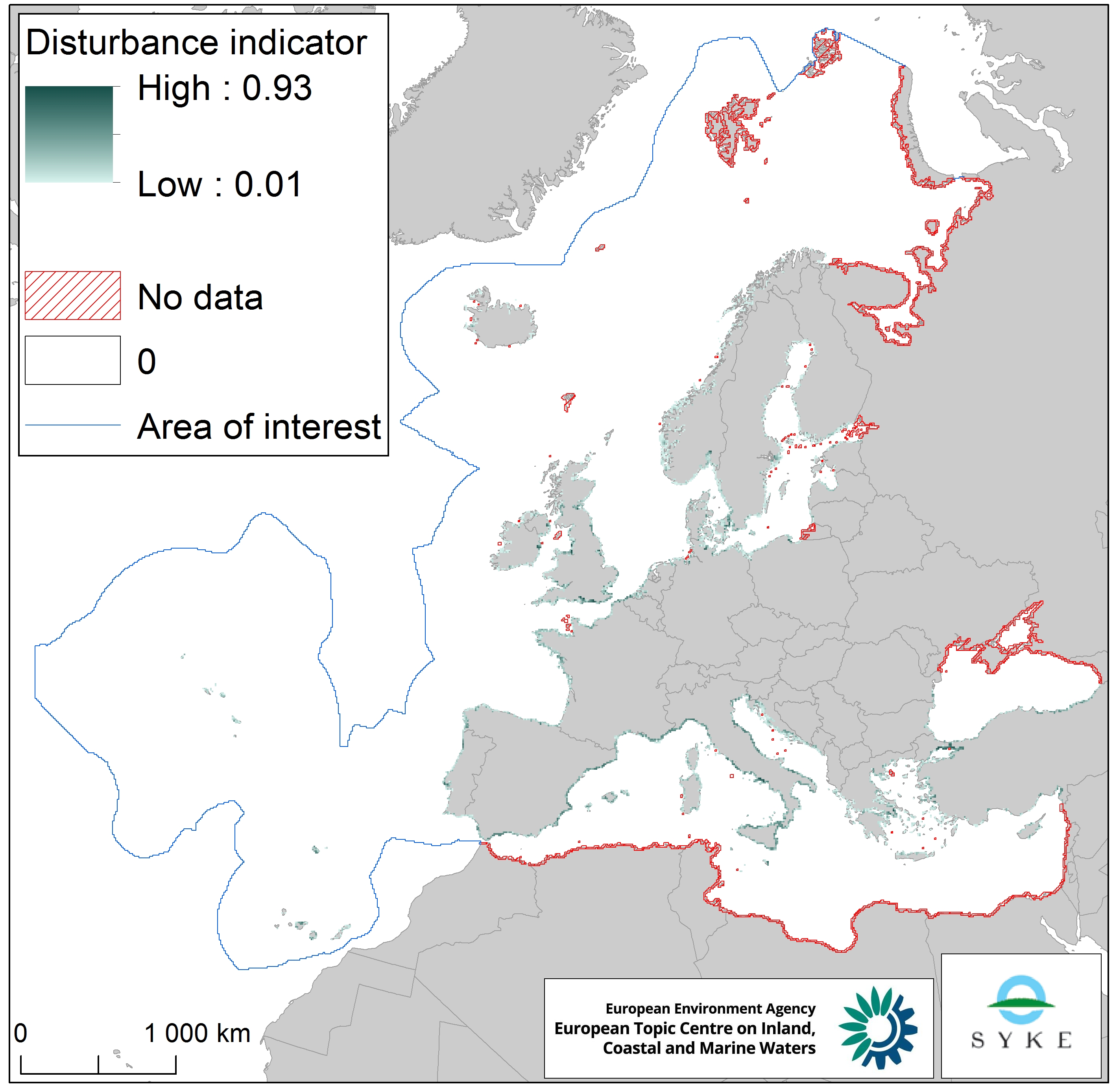
Disturbance of species due to human presence along European coastlines, Jan. 2020
The raster dataset represents the intensity of species disturbance due to human presence along European coastlines.
The dataset was created by combining the coastal urbanisation layer derived from Corine Land Cover 2012 (with the percentage of urbanised coastline per EEA 10 km grid cell) and the population density layer based on EUROSTAT NUTS 2016 data (with the population density in the NUTS 3 region corresponding to the coastal EEA 10 km grid cell). The dataset does not cover southern and western Mediterranean Sea, northern Black Sea and northernmost Atlantic Ocean.
The dataset was prepared for the combined effect index produced for the ETC/ICM Report 4/2019 "Multiple pressures and their combined effects in Europe's seas" available on: https://www.eionet.europa.eu/etcs/etc-icm/etc-icm-report-4-2019-multiple-pressures-and-their-combined-effects-in-europes-seas-1.
Simple
- Date (Creation)
- 2018-09-01
- Date (Publication)
- 2020-01-27
- Edition
- 01.00
- Identifier
- eea_r_3035_10_km_species-disturbance_p_2012-2016_v01_r00
Point of contact
- Maintenance and update frequency
- As needed
- Keywords
-
- Keywords
-
- GEMET
-
- population density
- pressure
- species
- sea
- environmental pressure
- urbanisation
- coastal environment
- coast
- Continents, countries, sea regions of the world.
-
- Northeast Atlantic Ocean (40W)
- Iceland Sea
- North Sea
- Mediterranean Sea
- Bay of Biscay
- Kattegat
- Barents Sea
- Ionian Sea
- Black Sea
- Norwegian Sea
- Celtic Sea
- Baltic Sea
- English Channel
- Adriatic Sea
- Spatial scope
-
- European
- EEA topics
-
- Biodiversity
- Land use
- Seas and coasts
- Sous-regions marines
-
- /Métropole
- /Métropole/Manche mer du Nord
- /Métropole/Mers Celtiques
- /Métropole/Golfe de Gascogne
- /Métropole/Méditerranée occidentale
- Thématiques - SIMM
-
- /Activités et Usages/Analyse économique et sociale
- Thématiques - SIMM
-
- /Activités et Usages/Urbanisation et Artificialisation
- Thématiques - SIMM
-
- /Etat du Milieu/Littoral
- Type de jeux de donnée - ODATIS
-
- /Données dérivées/Produits composites
- Access constraints
- Other restrictions
- Other constraints
- no limitations to public access
- Use constraints
- Other restrictions
- Other constraints
- License CC-BY 4.0 (https://creativecommons.org/licenses/by/4.0/). Copyright holder: European Environment Agency (EEA).
- Spatial representation type
- grid Grid
- Distance
- 10 km
- Metadata language
- English
- Topic category
-
- Environment
- Oceans
))
- Begin date
- 2012-01-01
- End date
- 2016-12-31
- Unique resource identifier
- EPSG:3035
- Distribution format
-
-
GeoTIFF
(
)
-
GeoTIFF
(
)
- OnLine resource
- disturbance_to_species_normalize.tif ( EEA:FOLDERPATH )
- OnLine resource
- Direct download ( WWW:URL )
- Hierarchy level
- Dataset
Domain consistency
Conformance result
- Date (Publication)
- 2010-12-08
- Explanation
- See the referenced specification
- Statement
-
The dataset was made by combining coastal urbanisation and population density datasets. The coastal urbanisation layer was derived from CORINE Land Cover 2012 vector layer and shows the percentage of urbanised coastline per EEA 10 km grid cell. The population density layer (based on EUROSTAT NUTS 2016 data, metadata on: https://gisco-services.ec.europa.eu/distribution/v2/nuts/nuts-2016-metadata.xml ) shows the population density in the NUTS 3 region within which the coastal cells of the EEA 10 x 10 km grid fall into. The coastal urbanisation and populations density layers were combined by first log10 transforming and normalising the population density layer, then multiplying the layers with each other.
The temporal extent varies between the data sources (2012 for coastal urbanisation, 2016 for population density).
- File identifier
- 670cb5a9-40b9-4b12-90e3-597de5927700 XML
- Metadata language
- English
- Character set
- UTF8
- Hierarchy level
- Dataset
- Date stamp
- 2025-10-09T10:55:04.219975Z
- Metadata standard name
- ISO 19115/19139
- Metadata standard version
- 1.0
Overviews
Spatial extent
Provided by
