 Catalogue PIGMA
Produits altimétriques expérimental (M)SLA et (M)ADT nouvelle résolution - Hauteurs et Courants - temps différé - (multimissions, niveaux 3 et 4)
Produit altimétrique combiné expérimental intégrant une meilleure résolution, en vue de la préparation de l'ère SWOT comprenant les hauteurs de mer par rapport à une moyenne sur 20 années ainsi que les courants géostrophiques, issu de traitement spécifiques, disponibles en temps différé. Utilisation pour des études de variabilité océanique à méso-échelles.
Produits régionaux:
- le long de la trace, anomalies de hauteur de mer à 5Hz: Atlantique Nord, courant des Aiguilles
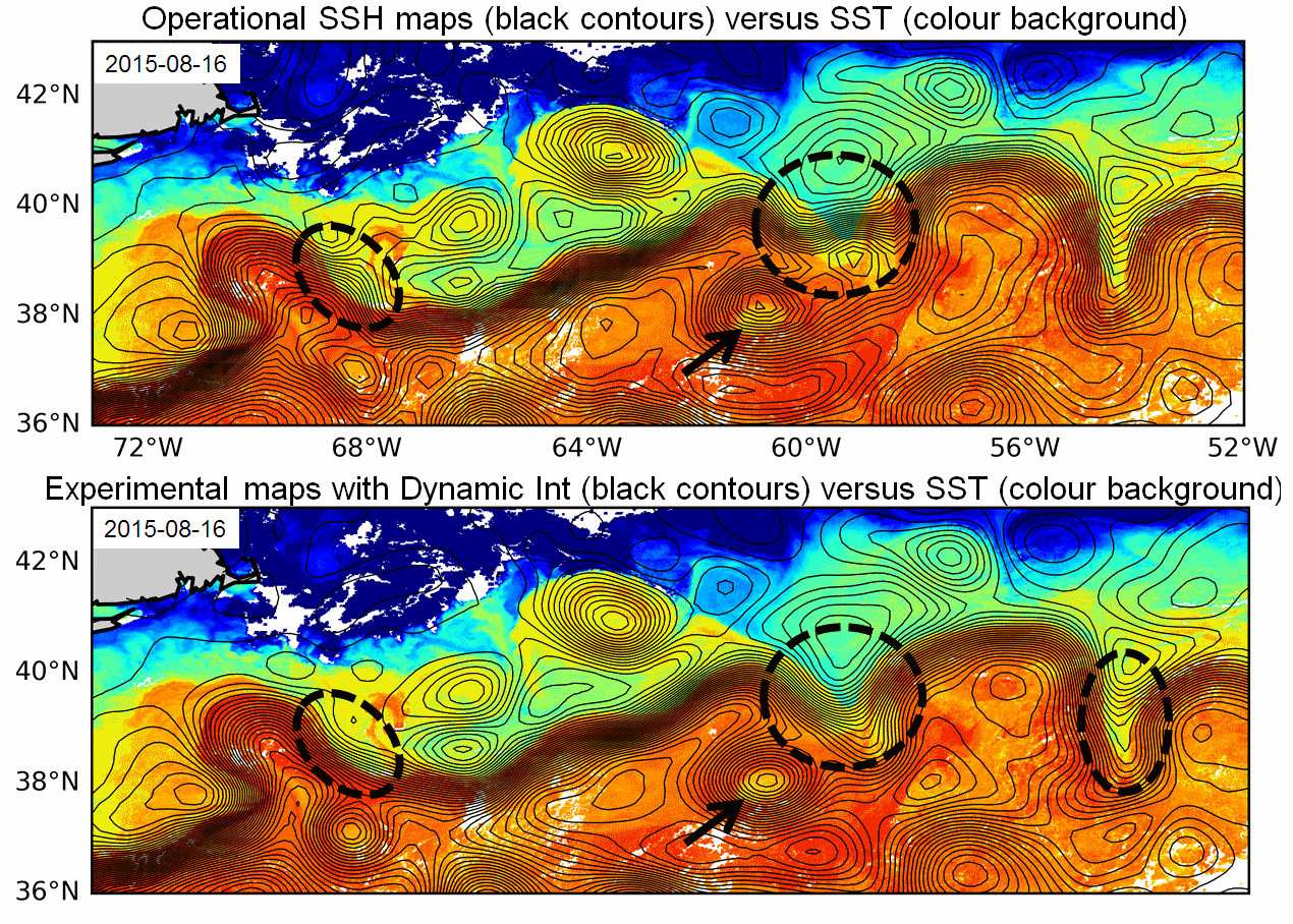
- grillés, hauteurs de mer et vitesses géostrophiques calculés par Interpolation Dynamique: 2 zones: Gulf Stream, Udinstev.
- grillés, anomalies de hauteur de mer et vitesses géostrophiques combinant altimétrie et bouées dérivantes: Golfe du Mexique
Produit en zone globale:
- grillés, vitesses combinées de façon optimale de données altimétriques et SST: global.
A noter que ce produit grillé, combinant les données altimétriques et SST ont été calculés dans le cadre de 3 projets différents: 1/ une association Marie-Curie cofondée par l'Union Européenne sous le FP7-PEOPLE-Cofunding of Regional, National and International Programmes Grant Agreement 600407 et le projet RITMARE FLAG project (2014-2016), 2/ le projet ESA Globcurrent (2014-2018), 3/ le projet DUACS-MR CNES (2016-2018).
Références pour les produits grillés calculés par interpolation dynamique:
- Ubelmann, C., P. Klein, and L.-L. Fu, 2015: Dynamic interpolation of sea surface height and potential applications for future high-resolution altimetry mapping. J. Atmos. Oceanic Technol., 32, 177–184, doi:10.1175/JTECH-D-14-00152.1.
- Ubelmann C., B. Cornuelle and L-L Fu, 2016: Dynamic Mapping of Along-Track Ocean Altimetry: Method and Performance from Observing System Simulation Experiments. J. Atmos. Oceanic Technol., doi:10.1175/JTECH-D-15-0163.1
- Rogé, M., Morrow R., Ubelmann C. and G. Dibarboure, 2017 : Using a dynamical advection to reconstruct a part of the SSH evolution in the context of SWOT, application to the Mediterranean Sea. Ocean Dynamics, 67-8, 1047–1066
- Ubelmann C., M. Ballarotta, Y. Faugere, M. Rogé, R. Morrow, G. Dibarboure, Upcoming high-resolution regional products of Sea Level Anomaly from Dynamic Interpolation, OSTS 2017
Références pour les produits grillés combinant altimétrie et bouées dérivantes:
- Synergetic use of surface drifters and altimetry to increase resolution and accuracy of maps of sea level anomaly in the Gulf of Mexico, Mulet et al, OSTST 2017
Référencespour les produits grillés combinant données altimétriques et SST:
- Rio, M-H, R. Santoleri, R. Bourdalle-Badie, A. Griffa, L. Piterbarg, G. Taburet, 2016: Improving the altimeter derived surface currents using high-resolution Sea Surface Temperature data: A feasibility study based on model outputs. Journal of Atmospheric and Oceanic Technology, Vol. 33, DOI: 10.1175/JTECH-D-16-0017.1.
Simple
- Date (Publication)
- 2018-06-01
- Date
- Credit
- CDS-AVISO
- Centre de données ODATIS
-
- CDS-AVISO
- Keywords
-
- Cersat - GCMD parameter
-
- /Sea Surface Topography/Sea Surface Height
- /Ocean Circulation/Ocean Currents
- Use limitation
- Licence ouverte
- Access constraints
- License
- Use constraints
- License
- Other constraints
- Licence Ouverte
- Other constraints
- Les conditions d'utilisation sont spécifiés dans la licence : Ce jeu de données est soumis à des conditions spécifiques d'utilisation dont les détails sont précisés dans la licence https://www.aviso.altimetry.fr/fileadmin/documents/data/License_Aviso.pdf, Users should keep in mind that these products are experimental products. Notably, they are not produced on an operational basis. Citations : "Those products were processed by SSALTO/DUACS and distributed by AVISO (https://www.aviso.altimetry.fr) with support from CNES, https://doi.org/10.24400/527896/a01-2021.003”
- Spatial representation type
- grid Grid
- Metadata language
- Français
- Character set
- utf8 UTF8
- Topic category
-
- Oceans
))
- Begin date
- 2016-07-01
- End date
- 2018-12-22
- Geometric object type
- Complex
- Distribution format
-
-
NetCDF
(
)
-
NetCDF
(
)
- OnLine resource
-
Accès authentifié aux données le long de la trace, 5 Hz
(
WWW:LINK
)
Accès authentifié aux données
OnLine resource
OnLine resource
OnLine resource
- OnLine resource
-
TDS fileserver données combinées avec température
(
WWW:LINK
)
THREDDS
- OnLine resource
-
TDS fileserver combinées avec bouées
(
WWW:LINK
)
THREDDS
- OnLine resource
-
TDS fileserver données avec interpolation dynamique
(
WWW:LINK
)
THREDDS
- OnLine resource
-
TDS fileserver le long de la trace 5 Hz
(
WWW:LINK
)
THREDDS
- OnLine resource
-
User guide
(
WWW:LINK
)
Product User Manual (handbook)
- OnLine resource
- Digital Object Identifier (DOI) ( DOI )
- Hierarchy level
- Dataset
- Statement
-
Produits régionaux:
- le long de la trace, anomalies de hauteur de mer à 5Hz: Atlantique Nord, courant des Aiguilles
- grillés, hauteurs de mer et vitesses géostrophiques calculés par Interpolation Dynamique: 2 zones: Gulf Stream, Udinstev.
- grillés, anomalies de hauteur de mer et vitesses géostrophiques combinant altimétrie et bouées dérivantes: Golfe du Mexique
Produit en zone globale:
- grillés, vitesses combinées de façon optimale de données altimétriques et SST: global.
A noter que ce produit grillé, combinant les données altimétriques et SST ont été calculés dans le cadre de 3 projets différents: 1/ une association Marie-Curie cofondée par l'Union Européenne sous le FP7-PEOPLE-Cofunding of Regional, National and International Programmes Grant Agreement 600407 et le projet RITMARE FLAG project (2014-2016), 2/ le projet ESA Globcurrent (2014-2018), 3/ le projet DUACS-MR CNES (2016-2018).
Références pour les produits grillés calculés par interpolation dynamique:
- Ubelmann, C., P. Klein, and L.-L. Fu, 2015: Dynamic interpolation of sea surface height and potential applications for future high-resolution altimetry mapping. J. Atmos. Oceanic Technol., 32, 177–184, doi:10.1175/JTECH-D-14-00152.1.
- Ubelmann C., B. Cornuelle and L-L Fu, 2016: Dynamic Mapping of Along-Track Ocean Altimetry: Method and Performance from Observing System Simulation Experiments. J. Atmos. Oceanic Technol., doi:10.1175/JTECH-D-15-0163.1
- Rogé, M., Morrow R., Ubelmann C. and G. Dibarboure, 2017 : Using a dynamical advection to reconstruct a part of the SSH evolution in the context of SWOT, application to the Mediterranean Sea. Ocean Dynamics, 67-8, 1047–1066
- Ubelmann C., M. Ballarotta, Y. Faugere, M. Rogé, R. Morrow, G. Dibarboure, Upcoming high-resolution regional products of Sea Level Anomaly from Dynamic Interpolation, OSTS 2017
Références pour les produits grillés combinant altimétrie et bouées dérivantes:
- Synergetic use of surface drifters and altimetry to increase resolution and accuracy of maps of sea level anomaly in the Gulf of Mexico, Mulet et al, OSTST 2017
Référencespour les produits grillés combinant données altimétriques et SST:
- Rio, M-H, R. Santoleri, R. Bourdalle-Badie, A. Griffa, L. Piterbarg, G. Taburet, 2016: Improving the altimeter derived surface currents using high-resolution Sea Surface Temperature data: A feasibility study based on model outputs. Journal of Atmospheric and Oceanic Technology, Vol. 33, DOI: 10.1175/JTECH-D-16-0017.1.
- Processing level code
- L4
- File identifier
- 9154a1ac-e1e8-4587-ae14-891e01aa7fbf XML
- Metadata language
- Français
- Character set
- UTF8
- Hierarchy level
- Dataset
- Date stamp
- 2026-02-24T10:25:15.318379Z
- Metadata standard name
- ISO 19115-3:2018 - Remote Sensing ISO 19115-3:2018 - Remote Sensing
- Metadata standard version
- 1.0
Overviews
Spatial extent
Provided by
