 Catalogue PIGMA
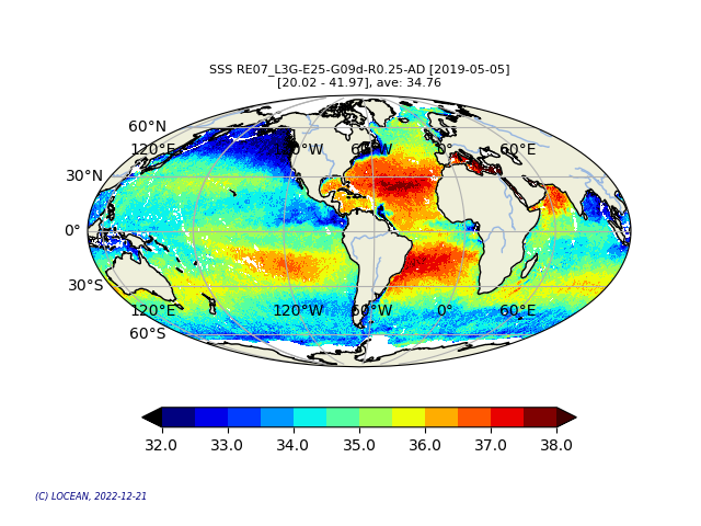
CATDS-PDC L3OS 3G - Debiased gaussian average daily salinity field product from SMOS satellite
Simple
- Date (Publication)
- 2022-12-09
- Date
- Identifier
- CATDS-PDC_L3OS_3G
- Credit
- CATDS (CNES, IFREMER, LOCEAN, ACRI)
- Thèmes Sextant
-
- /Imagery/Satellite Imagery
- GEMET - INSPIRE themes, version 1.0
-
- Orthoimagery
- Theme
-
- SMOS
- CATDS
- CPDC
- L3OS
- Ocean Salinity
- 3G
- Ocean Product
- Centre de données ODATIS
-
- CDS-CERSAT
- Type de jeux de donnée ODATIS
-
- /Données d'observation/satellite
- Use limitation
- Creative Commons license to apply : Attribution (BY) : http://creativecommons.org/licenses/?lang=en
- Access constraints
- License
- Use constraints
- License
- Spatial representation type
- grid Grid
- Denominator
- 1
- Metadata language
- English
- Character set
- utf8 UTF8
- Topic category
-
- Geoscientific information
))
- Begin date
- 2010-02-01
- Reference system identifier
- EPSG / WGS 84 / NSIDC EASE-Grid 2.0 Global (EPSG:6933) / 8.6
- Number of dimensions
- 3
- Dimension name
- Column
- Dimension size
- 1388
- Dimension name
- Vertical
- Dimension size
- 584
- Dimension name
- Sample
- Dimension size
- 14
- Cell geometry
- Area
- Transformation parameter availability
- No
- Distribution format
-
-
NetCDF
(
netcdf 3 with 64 bit offset option
)
-
NetCDF
(
netcdf 3 with 64 bit offset option
)
- OnLine resource
-
RE07
(
WWW:DOWNLOAD
)
RE07 - Reprocessed products (02/2010 - 05/2021)
- OnLine resource
-
OPER
(
WWW:DOWNLOAD
)
OPER - Operational products (06/2021 - now)
- OnLine resource
-
ATBD L3/L4 OS
(
WWW:LINK
)
Algorithm Theoretical Basis Document L3/L4 OS
- OnLine resource
- Pros/cons table ( WWW:LINK )
- OnLine resource
-
Reference
(
WWW:LINK-1.0-http--publication-URL
)
Boutin J., Vergely J.L., Marchand S., D'Amico F., Hasson A., Kolodziejczyk Nicolas, Reul Nicolas, Reverdin G., Vialard J. (2018). New SMOS Sea Surface Salinity with reduced systematic errors and improved variability. Remote Sensing of Environment, 214, 115-134. Publisher's official version : http://doi.org/10.1016/j.rse.2018.05.022 , Open Access version : http://archimer.ifremer.fr/doc/00441/55254/
- OnLine resource
-
FTP Access
(
WWW:DOWNLOAD
)
FTP Access - All products are also available by ftp : server ftp.ifremer.fr, login ext-catds-cpdc, passwd catds2010, path Ocean_products/GRIDDED/... (same relative paths as in the https links)
- OnLine resource
-
CATDS Sipad
(
WWW:LINK
)
CATDS Sipad - Web-based interactive tool which allows subsettings and temporal agregation.
- OnLine resource
-
CATDS Web portal
(
WWW:LINK
)
CATDS Web portal
- OnLine resource
- Digital Object Identifier (DOI) ( DOI )
- Hierarchy level
- Dataset
- Statement
-
The base products, for all the CATDS-PDC (Centre Aval de Traitement des Données SMOS - Production & Dissemination Center) processing chains, are the SMOS L1B products - https://doi.org/10.57780/SM1-e20cf57 - from ESA (European Space Agency).
From these, brightness temperatures at various incidence angles are reconstructed. The Sea Surface Salinity (SSS) are retrieved from multi-angular brightness temperatures through a maximum likehood Bayesian approach in which measured Tb and Tb simulated using a forward direct model are compared (see Zine et al. 2008 for a general description of the retrieval method, and pro_con table for a summary of the similarities/differences with respect to ESA level 2 ocean salinity processing).
The L3OS 3G product contains daily salinity fields from a 9 days temporal gaussian average, corrected from land-sea contamination and latitudinal bias, based on L2Q products, mixing ascending and descending orbits.
Products from reprocessing RE07 are available for the period 02/2010 - 05/2021. Products from operational (OPER) processing are available since 06/2021. Reprocessed products and operational products are derived using the same algorithm and configuration, hence ensuring the temporal continuity.
File naming :
SM_clas_MIR_CS3G09_startdate_enddate_vvv_ccc_7
- clas : File class (OPER : operational mode, REXX : reprocessing xx)
- startdate : sensing start date/time of the data (format yyyymmddThhmiss)
- enddate : sensing end date/time of the data (format yyyymmddThhmiss)
- vvv : version number of the processor generating the product
- ccc : file counter
File format :
In each archive file (.tgz extension), there are two files
- A Header file (.HDR), which is a text file, in XML Earth Explorer Header format
- A Data file (.DBL.nc), which is a netcdf file, format variant 2 (netcdf 3 with 64 bits offset option)
Reference :
Boutin J., Vergely J.L., Marchand S., D'Amico F., Hasson A., Kolodziejczyk Nicolas, Reul Nicolas, Reverdin G., Vialard J. (2018). New SMOS Sea Surface Salinity with reduced systematic errors and improved variability. Remote Sensing of Environment, 214, 115-134. Publisher's official version : http://doi.org/10.1016/j.rse.2018.05.022 , Open Access version : http://archimer.ifremer.fr/doc/00441/55254/
- File identifier
- 9c97fb5c-d7d5-4bc2-a5c7-57944026cd60 XML
- Metadata language
- English
- Character set
- UTF8
- Hierarchy level
- Dataset
- Date stamp
- 2025-11-06T15:20:21.931395Z
- Metadata standard name
- ISO 19115-3 - SEXTANT
- Metadata standard version
- 1.0
Overviews
Spatial extent
Provided by
