 Catalogue PIGMA
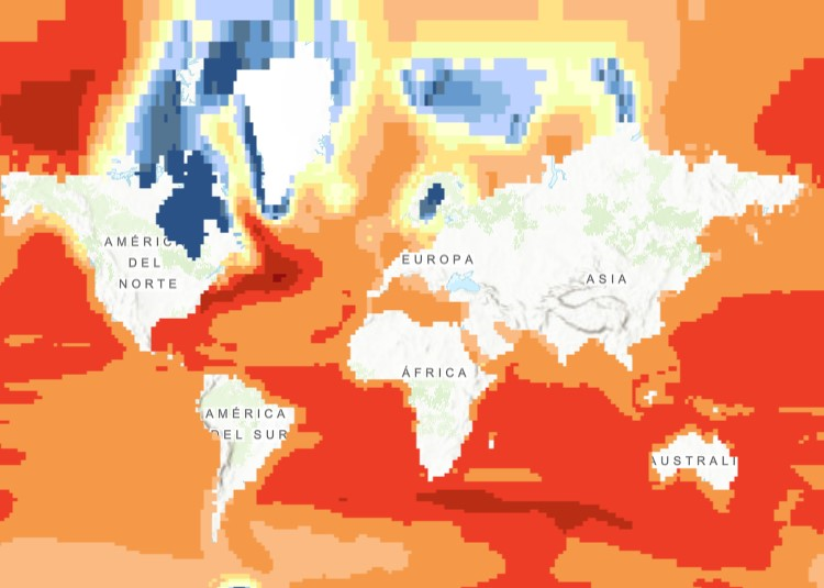
Projected change in relative sea level (2081-2100), Jul. 2014
The raster dataset (1ºx1º) shows the projected change in relative sea level (in metres) in 2081-2100 compared to 1986-2005 for the medium-low emission scenario RCP4.5, based on an ensemble of Coupled Model Intercomparison Project Phase 5 (CMIP5) climate models.
Projections consider land movement due to glacial isostatic adjustment but not land subsidence due to human activities. No projections are available for the Black Sea.
The dataset has been used as a source for an earlier version of the EEA indicator “Global and European Sea Level”: https://www.eea.europa.eu/data-and-maps/indicators/sea-level-rise-5/assessment.
Simple
- Date (Creation)
- 2014-07-25T00:00:00
- Date (Publication)
- 2014-07-25T00:00:00
- Edition
- 01.00
- Identifier
- eea_r_4258_60_arcmin_proj-sea-level-rise_p_2081-2100_v01_r00
Point of contact
- Maintenance and update frequency
- Not planned
- Keywords
-
- Keywords
-
- GEMET
-
- climate change adaptation
- climate change impact
- climate
- coastal flooding
- sea level rise
- ocean
- coast
- Continents, countries, sea regions of the world.
-
- World
- EEA topics
-
- Climate adaptation
- Sous-regions marines
-
- /Métropole
- /Métropole/Manche mer du Nord
- /Métropole/Mers Celtiques
- /Métropole/Golfe de Gascogne
- /Métropole/Méditerranée occidentale
- Thématiques - SIMM
-
- /Etat du Milieu/Littoral
- Type de jeux de donnée - ODATIS
-
- /Données dérivées/Données de type modèle
Resource constraints
- Access constraints
- Other restrictions
- Other constraints
- no limitations to public access
- Use constraints
- Other restrictions
- Other constraints
-
License CC-BY 4.0 (https://creativecommons.org/licenses/by/4.0/).
Copyright holder: European Environment Agency (EEA), Integrated Climate Data Centre (ICDC).
- Spatial representation type
- grid Grid
- Distance
- 1 deg
- Distance
- 60 arcmin
- Metadata language
- English
- Topic category
-
- Environment
- Climatology, meteorology, atmosphere
- Begin date
- 2081-01-01
- End date
- 2100-12-31
))
- Unique resource identifier
- EPSG:4258
- Distribution format
-
-
GeoTIFF
(
)
-
GeoTIFF
(
)
- OnLine resource
- https://sdi.eea.europa.eu/webdav/datastore/public/eea_r_4258_60_arcmin_proj-sea-level-rise_p_2081-2100_v01_r00/ ( EEA:FOLDERPATH )
- OnLine resource
- https://climate-adapt.eea.europa.eu/en/knowledge/tools/urban-adaptation ( WWW:LINK-1.0-http--link )
- OnLine resource
- Direct download ( WWW:URL )
- OnLine resource
- https://climate.discomap.eea.europa.eu/arcgis/services/UAMV/Projected_change_in_relative_sea_level_in_2081_2100/MapServer/WMSServer?request=GetCapabilities&service=WMS ( OGC:WMS )
- OnLine resource
- https://climate.discomap.eea.europa.eu/arcgis/rest/services/UAMV/Projected_change_in_relative_sea_level_in_2081_2100/MapServer ( ESRI:REST )
- OnLine resource
- EEA Indicator ( WWW:LINK-1.0-http--link )
- Hierarchy level
- Dataset
Conformance result
- Date (Publication)
- 2010-12-08
- Explanation
- See the referenced specification
- Statement
-
Based on the Figure TS-23.b in the Working Group I contribution to the Fifth Assessment Report of the Intergovernmental Panel on Climate change (IPCC), Chapter 13, http://www.ipcc.ch/pdf/assessment-report/ar5/wg1/WG1AR5_Chapter13_FINAL.pdf . The dataset were provided by Marc Carson (ZMAW), who is a contributing author to this chapter.
Gaps in data coverage (of grid cells partly covered by land and partly by sea) were filled using the nearest-neighbour method.
- File identifier
- bebe21b4-15cf-480b-80b7-b6e229676bea XML
- Metadata language
- English
- Character set
- UTF8
- Hierarchy level
- Dataset
- Date stamp
- 2025-10-09T11:12:27.210849Z
- Metadata standard name
- ISO 19115/19139
- Metadata standard version
- 1.0
Overviews
Spatial extent
Provided by
