 Catalogue PIGMA
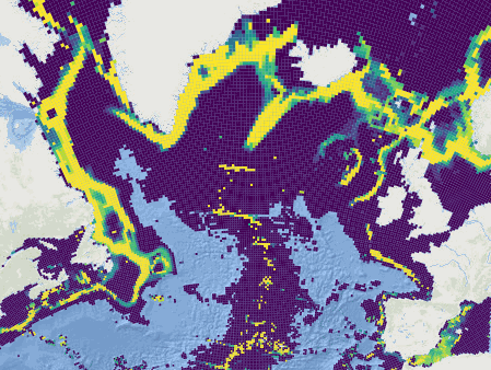
Systematic conservation planning for the North-Atlantic deep sea
This dataset was built to feed a basin-wide spatial conservation planning exercise, targeting the deep sea of the North Atlantic, in the framework of the ATLAS H2020 project. This approach aimed to inform Marine Spatial Planning and conservation initiatives for the deep sea of the North Atlantic, by identifying conservation priority areas for the Vulnerable Marine Ecosystems (VMEs) and deep fish species and discussing the efficiency of the current spatial management context relatively to conservation stakes.
This publication provides (1) the links to spatial datasets used as an input, (2) the R scripts used to run the final conservation scenarios together with associated table of targets and connectivity matrix, that can be run on the input data, and (3) the outputs of the final scenarios constructed and computed for ATLAS.
Produced by IFREMER.
Simple
- Date (Publication)
- 2019-09-10
- Date (Revision)
- 2021-05-12
- Other citation details
-
Combes Magali, Vaz Sandrine (2019). Systematic conservation planning for the North-Atlantic deep sea. SEANOE. https://doi.org/10.17882/62541
In addition to properly cite this dataset, it would be appreciated that the following work(s) be cited too, when using this dataset in a publication :
Combes M., Vaz S., Arnaud-Haond S., Morato T., Dominguez-Carrió C., Fox A., Manuel González-Irusta J., Johnson, D., Callery O., Davies A., Fauconnet L., Grehan A., Orejas C., Taranto G., Menot L., (2020). Systematic conservation planning at an ocean basin scale: identifying a viable network of deep-sea protected areas in the North Atlantic and the Mediterranean. Submitted
Magali Combes, Sandrine Vaz, Telmo Morato, Laurence Fauconnet, Sophie Arnaud-Haond, Carlos Dominguez-Carrió, Alan Fox, José-Manuel González-Irusta, Marina Carreiro-Silva, Andrew Davies, Pablo Durán Muñoz, Hrönn Egilsdóttir, Lea-Anne Henry, Ellen Kenchington, Camille Lirette, F. Javier Murillo-Perez, Covadonga Orejas, Berta Ramiro-Sánchez, Luís Rodrigues, Steve W. Ross, Dick van Oevelen, Christopher K. Pham, Carlos Pinto, Neil Golding, Jeff A. Ardron, Francis Neat, Xuan Bui, Oisin Callery, Anthony Grehan, Pascal Laffargue, Murray Roberts, David Stirling, Gerald Taranto, Mathieu Woillez, Lénaick Menot (2019). ATLAS D3.4 Conservation Management Issues in ATLAS. Basin-scale systematic conservation planning: identifying suitable networks for VMEs protection.
- Credit
- This work has received funding from the European Union’s Horizon 2020 research and innovation program under grant agreements no. 678760 (ATLAS) and 679849 (SponGES).
- Theme
-
- systematic conservation planning
- prioritization
- deep sea
- Atlantic
- Environment
- project
-
- FP7 ATLAS (Agreement: 678760)
- H2020 SponGES (Agreement: 679849)
- Use limitation
- CC-BY-NC-SA (Creative Commons - Attribution, No commercial usage, Sharing under the same conditions)
- Use constraints
- Other restrictions
- Other constraints
-
This output reflects the authors’ views and the European Union is not responsible for any use that may be made of the information it contains.
The scripts referenced here were used in the operation of the Atlas project, and may be freely copied and used to support your work. Please note that you use these scripts at your own risk. No warranty is expressed or implied and no liability is accepted for any inconveniences or damages that may ensue from their use.
- Date (Publication)
- 2021
- Unique resource identifier
- 10.3389/fmars.2021.611358
- Association Type
- Cross reference
- Initiative Type
- Study
- Metadata language
- English
- Topic category
-
- Oceans
))
- Distribution format
-
-
R SCRIPT
(
)
-
CSV
(
)
-
RDATA
(
)
-
SHAPEFILE
(
)
-
PDF
(
)
-
R SCRIPT
(
)
- OnLine resource
-
Script 1 : Create files for features and provinces - 10 KB
(
WWW:DOWNLOAD-1.0-link--download
)
Script 1 : Create files for features and provinces - 10 KB
- OnLine resource
-
Script 2 : Create cost indices - 10 KB
(
WWW:DOWNLOAD-1.0-link--download
)
Script 2 : Create cost indices - 10 KB
- OnLine resource
-
Script 3 : Run scenarios - 37 KB
(
WWW:DOWNLOAD-1.0-link--download
)
Script 3 : Run scenarios - 37 KB
- OnLine resource
-
Script 4 : Functions to create outputs used in script 3 - 8 KB
(
WWW:DOWNLOAD-1.0-link--download
)
Script 4 : Functions to create outputs used in script 3 - 8 KB
- OnLine resource
-
Processed data
(
WWW:DOWNLOAD-1.0-link--download
)
Table of conservation targets - 2 KB
- OnLine resource
-
Connectivity matrix for the “connectivity with 20 days PLD” scenario - 7 MB
(
WWW:DOWNLOAD-1.0-link--download
)
Connectivity matrix for the “connectivity with 20 days PLD” scenario - 7 MB
- OnLine resource
-
Processed data
(
WWW:DOWNLOAD-1.0-link--download
)
Spatial prioritization output: “base” scenario - 1 MB
- OnLine resource
-
Processed data
(
WWW:DOWNLOAD-1.0-link--download
)
Spatial prioritization output: “connectivity with 20 days PLD” scenario - 823 KB
- OnLine resource
-
Processed data
(
WWW:DOWNLOAD-1.0-link--download
)
Spatial prioritization output: “small base” scenario - 830 KB
- OnLine resource
-
Processed data
(
WWW:DOWNLOAD-1.0-link--download
)
Spatial prioritization output: “management” scenario - 1 MB
- OnLine resource
-
Processed data
(
WWW:DOWNLOAD-1.0-link--download
)
Supplementary spatial prioritization output: “all benthic regionalised” scenario - 1 MB
- OnLine resource
-
Sensor metadata - 91 KB
(
WWW:DOWNLOAD-1.0-link--download
)
Sensor metadata - 91 KB
- OnLine resource
- DOI of the product ( WWW:LINK-1.0-http--metadata-URL )
- OnLine resource
- Seanoe ( rel-canonical )
- Hierarchy level
- Dataset
- File identifier
- seanoe:62541 XML
- Metadata language
- English
- Character set
- UTF8
- Hierarchy level
- Dataset
- Date stamp
- 2021-05-12
- Metadata standard name
- ISO 19115:2003/19139
- Metadata standard version
- 1.0
Overviews
Spatial extent
Provided by
