 Catalogue PIGMA
Gironde Estuary Mouth MEasurement Stations (GEMMES)
Simple
- Date (Publication)
- 2021
- Date (Revision)
- 2021-05-12
- Other citation details
- Grasso Florent, Bocher Alan, Jacquet Matthias, Le Berre David, Lecornu Fabrice (2021). Gironde Estuary Mouth MEasurement Stations (GEMMES). SEANOE. https://doi.org/10.17882/78968
- Credit
-
This work was done as part of the AMORAD project and received a state fund managed by the Agence Nationale de la Recherche (ANR) under the
program Investissements d′avenir (AMORAD‐ANR‐11‐RSNR‐0002).
Measurements were carried out in the framework of the METEOR cruises (Grasso, 2017).
GRASSO F. (2017). METEOR 2017 cruise, RV Côtes De La Manche, https://doi.org/10.17600/17010200
- Theme
-
- Gironde Estuary
- Bay of Biscay
- Hydrodynamics
- Sediment dynamics
- Turbidity
- Current velocity
- Continental shelf
- Buoy measurement
- Benthic mooring
- Environment
- Physical oceanography
- Use limitation
- CC-BY (Creative Commons - Attribution)
- Use constraints
- Other restrictions
- Other constraints
- Ifremer
- Date (Publication)
- 2024
- Unique resource identifier
- 10.1016/j.csr.2024.105334
- Association Type
- Cross reference
- Initiative Type
- Study
- Unique resource identifier
- 10.17600/17010200
- Association Type
- Cross reference
- Initiative Type
- Platform
- Metadata language
- English
- Topic category
-
- Oceans
))
- Begin date
- 2016-11
- End date
- 2017-12
- Distribution format
-
-
TEXTE
(
)
-
TEXTE
(
)
- OnLine resource
-
Processed data
(
WWW:DOWNLOAD-1.0-link--download
)
GEMMES_dataset - 25 MB
- OnLine resource
- DOI of the product ( WWW:LINK-1.0-http--metadata-URL )
- OnLine resource
- Seanoe ( rel-canonical )
- Hierarchy level
- Dataset
- Statement
-
The GEMMES dataset includes measurements collected at two locations (GEMMES-20 and GEMMES-40).
1/ GEMMES-20 (N 45.6375; W 1.3917), in front of the Gironde Estuary Mouth:
- Surface measurements from a buoy station moored around 20-m water depth (CTD Sea-Bird SBE19+, turbidimeter Wetlab FLNTU, 1-m below mean sea level, every 15 minutes), data file ‘GEMMES-20_hydrosed.txt’ with Time, Temperature (°C), Salinity (PSU), Turbidity (NTU) and SPM concentration (g/l).
- Water samples at the sea surface (1-m below mean sea level) and at the bottom (1-m above bed level), data file ‘Samples_NISKIN_GEMMES-20.txt’ with Time, Water depth (Bottom/Surface) and SPM concentration (g/l).
2/ GEMMES-40 (N 45.7167; W 1.5750), on the West Gironde Mud Patch offshore of the Gironde Estuary Mouth:
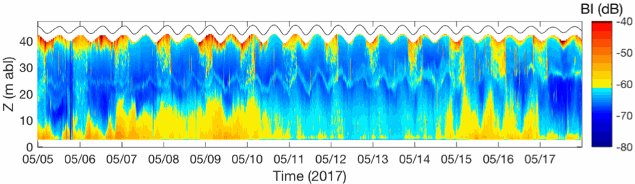
- Bottom measurements from a benthic station at around 40-m water depth: data file ‘GEMMES-40_hydrosed.txt’ (turbidimeter Wetlab FLNTU, 1-m above bed level, every 15 minutes) with Time, Turbidity (NTU) and SPM concentration (g/l); data folder ‘GEMMES-40_ADCP’ (ADCP 600 WORKHORSE, 1-m above bed level, every 10 minutes) with vertical profiles (50-cm cells) of Time, 3D current velocities (u, v, w), Water Depth, Backscatter Index, Significant wave height, Wave peak period.
- Water samples at the sea surface (1-m below mean sea level) and at the bottom (1-m above bed level), data file ‘Samples_NISKIN_GEMMES-40.txt’ with Time, Water depth (Bottom/Surface) and SPM concentration (g/l).
- File identifier
- seanoe:78968 XML
- Metadata language
- English
- Character set
- UTF8
- Hierarchy level
- Dataset
- Date stamp
- 2021-05-12
- Metadata standard name
- ISO 19115:2003/19139
- Metadata standard version
- 1.0
Overviews
Spatial extent
Provided by
