 Catalogue PIGMA
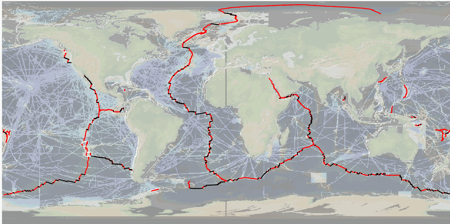
MAPRIDGES: Global Database of Mid-Oceanic Ridges Segments and Transform Faults
Simple
- Date (Publication)
- 2026-04-02
- Date (Revision)
- 2026-05-19
- Other citation details
- Sautter Benjamin, Escartin Javier, Petersen Sven, Gaina Carmen, Granot Roi, Pubellier Manuel (2026). MAPRIDGES: Global Database of Mid-Oceanic Ridges Segments and Transform Faults. SEANOE. https://doi.org/10.17882/99981
- Theme
-
- Ridge segment
- Transform Faults
- Non Transform Offset
- Transform Zone
- Oceanic Plate Boundary
- Digitization
- High Resolution
- Marine geology
- Use limitation
- CC-BY (Creative Commons - Attribution)
- Use constraints
- Other restrictions
- Metadata language
- English
- Topic category
-
- Oceans
))
- Distribution format
-
-
SHP
(
)
-
PDF
(
)
-
GPKG
(
)
-
SHP
(
)
- OnLine resource
-
MAPRIDGES Version 1 (obsolete version) [RESTRICTED] - 309 KB
(
WWW:DOWNLOAD-1.0-link--download
)
MAPRIDGES Version 1 (obsolete version) [RESTRICTED] - 309 KB
- OnLine resource
-
ReadMe - 108 KB
(
WWW:DOWNLOAD-1.0-link--download
)
ReadMe - 108 KB
- OnLine resource
-
Processed data
(
WWW:DOWNLOAD-1.0-link--download
)
MAPRIDGESv2602_ContinuousBoundary [RESTRICTED] - 284 KB
- OnLine resource
-
Processed data
(
WWW:DOWNLOAD-1.0-link--download
)
MAPRIDGESv2602_RS [RESTRICTED] - 600 KB
- OnLine resource
-
Processed data
(
WWW:DOWNLOAD-1.0-link--download
)
MAPRIDGESv2602_TF [RESTRICTED] - 180 KB
- OnLine resource
-
Processed data
(
WWW:DOWNLOAD-1.0-link--download
)
MAPRIDGESv2602_TZ [RESTRICTED] - 104 KB
- OnLine resource
- DOI of the product ( WWW:LINK-1.0-http--metadata-URL )
- OnLine resource
- Seanoe ( rel-canonical )
- Hierarchy level
- Dataset
- File identifier
- seanoe:99981 XML
- Metadata language
- English
- Character set
- UTF8
- Hierarchy level
- Dataset
- Date stamp
- 2026-05-19
- Metadata standard name
- ISO 19115:2003/19139
- Metadata standard version
- 1.0
Overviews
Spatial extent
Provided by
