 Catalogue PIGMA
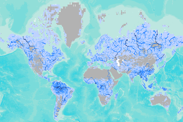
Global Annual River Discharge (km3/yr)
Global annual river discharge for a 0.5 degree resolution digital river network (blended, km3/yr per grid cell). Blended river flow represents a composite of observed and modeled river flow. Annual river discharge - computed as flow accumulated long term average runoff along a 30-minute resolution digital river network and blended with observed discharge data where available (km3/yr).
Simple
- Date (Publication)
- 2001-01-01
- Identifier
- 167cc1c6-af71-4182-b902-b0984199255e
- Purpose
- River discharge was computed as flow accumulated runoff along a 30-minute resolution digital river network (Fekete et al., 2001, Vorosmarty et al, 2000a,b). Blended river flow represents a composite of observed and modeled river flow.
- Credit
- Conservation Biology Institute (USA)
- GEMET - INSPIRE themes, version 1.0
-
- Hydrography
- Mission Atlantic - Resources
-
- Data
- Mission Atlantic - Case Studies
-
- Celtic Seas
- Canary Current system
- Atlantic Ocean
- Mission Atlantic - BODC Parameters
-
- /Cross-discipline/Fluxes
- Mission Atlantic - Data type (DMP)
-
- Environmental data
- Spatial data products
- Mission Atlantic - Work Package
-
- WP4 Benthic Mapping
- WP3 Pelagic Mapping
- Other constraints
- Reference Fekete et al., 2001
- Spatial representation type
- grid Grid
- Distance
- 0.5 degree
- Metadata language
- English
- Character set
- utf8 UTF8
- Topic category
-
- Oceans
N
S
E
W
))
- Unique resource identifier
- EPSG:4326
- Distribution format
-
-
GeoTIFF
(
1.0
)
-
GeoTIFF
(
1.0
)
- OnLine resource
- Global Annual River Discharge (km3/yr) ( DOI )
- Hierarchy level
- Dataset
- Statement
- River discharge was computed as flow accumulated runoff along a 30-minute resolution digital river network (Fekete et al., 2001, Vorosmarty et al, 2000a,b). Blended river flow represents a composite of observed and modeled river flow.
- File identifier
- 167cc1c6-af71-4182-b902-b0984199255e XML
- Metadata language
- English
- Character set
- UTF8
- Hierarchy level
- Dataset
- Date stamp
- 2025-05-15T21:28:52.75195Z
- Metadata standard name
- ISO 19115-3 - SEXTANT
- Metadata standard version
- 1.0
Point of contact
Ifremer
-
Sextant
ZI Pointe du Diable
,
Plouzane
,
Brittany
,
29280
,
France
https://sextant.ifremer.fr/eng
Overviews
Spatial extent
N
S
E
W
Provided by

Associated resources
Not available