 Catalogue PIGMA
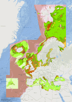
EUSeaMap 2021. Carte européenne de l’habitat des fonds marins à grande échelle
Simple
- Date (Publication)
- 2021-09-27
- Credit
- European Marine Observation and Data Network
- Status
- completed Completed
- DCSMM : Descripteurs
-
- D6: Intégrité des fonds marins
- D7: Changements hydrographiques
- Sous-regions marines
-
- /National
- Thématiques - SIMM
-
- /Etat du Milieu/Habitats
- Thèmes Sextant
-
- /Milieu physique/Habitats physiques
- Theme
-
- DCSMM
- Données prioritaires
- Place
-
- France
- GEMET - INSPIRE themes, version 1.0
-
- Habitats et biotopes
- Use limitation
- CC-BY 4.0
- Access constraints
- Other restrictions
- Use constraints
- Copyright
- Other constraints
- Please use attribution statement included within: EMODnet broad-scale seabed habitat map for Europe (v2019), licensed under CC-BY 4.0 from the European Marine Observation and Data Network (EMODnet) Seabed Habitats initiative (www.emodnet-seabedhabitats.eu), funded by the European Commission.
- Denominator
- 250000
- Metadata language
- Français
- Topic category
-
- Biota
- Environment
- Oceans
))
- Begin date
- 1975-01-01
- End date
- 2019-05-03
- Reference system identifier
- EPSG / WGS 84 (EPSG:4326) / 7.4
- Distribution format
-
-
Web Mapping Service
(
1.1.0
)
-
Web Mapping Service
(
1.1.0
)
- OnLine resource
- EMODnet Seabed Habitats Download page (EUSeaMap preselected) ( WWW:LINK )
- OnLine resource
-
eusm2021_eunis2007_group
(
OGC:WMS-1.1.1-http-get-map
)
EUSeaMap 2021 EUNIS 2007 Classification Group - all simplification levels
- OnLine resource
- Digital Object Identifier (DOI) ( DOI )
- Hierarchy level
- Dataset
Domain consistency
- Statement
-
The model is produced using R and Arc Model Builder (10.1).
The model was created using raster input layers with a cell size of 0.00104dd (roughly 100 metres). The model includes the sublittoral zone only; due to the high variability of the littoral zone, a lack of detailed substrate data and the resolution of the model, it is difficult to predict littoral habitats at this scale.
EUSeaMap is classified into EUNIS 2019 level 3 (or more detailed levels where appropriate), EUNIS 2019 level 2 , EUNIS 2007-2011, the MSFD benthic broad habitat types, the HELCOM HUB classification in the Baltic, and the recently revised habitat classification in the Mediterranean. In the Black Sea, EUSeaMap is not classified into EUNIS 2007-2011 (due to inapplicability), but is classified according to a classification that was developed by EMODnet Seabed Habitats (Populus et a, 2017, and for a revised version Vasquez et al, 2020, See Online resources).
- File identifier
- 2e602923-d9cb-4005-9dfa-eec2b8959c37 XML
- Metadata language
- Français
- Character set
- MD_CharacterSetCode_utf8
- Hierarchy level
- Dataset
- Date stamp
- 2025-05-15T21:51:36.278329Z
- Metadata standard name
- ISO 19115-3 - SEXTANT ISO 19115-3 - SEXTANT
- Metadata standard version
- 1.0
Overviews
Spatial extent
Provided by
