 Catalogue PIGMA
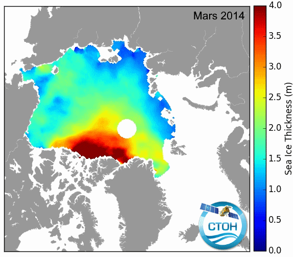
[OLD TEMPLATE] Sea Ice Freeboard, Thickness and Snow Depth (Arctic and Antarctic)
These data contain monthly mean gridded seaice products from altimetry including the following parameters over Arctic and Antarctic areas:
- radar freeboard (direct Ku measurement)
- ice freeboard (radar freeboard corrected from Ku speed propagation in Snow Depth)
- snow depth (SD)
- sea ice thickness (Sea Ice Thickness(SIT), using SD)
The survey of these high latitudes requires satellite altimeters with high latitude orbits : Saral/AltiKa, Cryosat-2 and Envisat.
Simple
- Date (Publication)
- 2017-11-17
- Credit
- CTOH, LEGOS
- Thèmes Sextant
-
- /Imagerie/Imagerie satellitale
- GEMET - INSPIRE themes, version 1.0
-
- Caractéristiques géographiques océanographiques
- Centre de données ODATIS
-
- CDS-SAT-AVISO
- Type de jeux de donnée ODATIS
-
- /Données d'observation/satellite
- Theme
-
- freeboard, snow depth, density, sea ice thickness
- Services Nationaux d'Observation
-
- SNO-CTOH
- ODATIS aggregation parameters and Essential Variable names
-
- Glace de mer
- Use limitation
- Aucune condition ne s’applique
- Access constraints
- Other restrictions
- Use constraints
- Copyright
- Other constraints
- “The data used in this study (doi 10.6096/CTOH_SEAICE_2019_12) were developed, validated by the CTOH/LEGOS, France and distributed by Aviso +”.
- Spatial representation type
- grid Grid
- Distance
- 12 km
- Metadata language
- Français
- Character set
- utf8 UTF8
- Topic category
-
- Oceans
))
- Begin date
- 2002-01
- End date
- 2019-12 Before
- Geometric object type
- Point
- Distribution format
-
-
(
)
-
(
)
- OnLine resource
- Accès authentifié aux données ( WWW:LINK )
- OnLine resource
- Plus d'information sur AVISO+ ( WWW:LINK )
- OnLine resource
- Manuel utilisateur ( WWW:LINK )
- OnLine resource
- TDS fileserver Sea Ice Freeboard, Thickness and Snow Depth ( WWW:DOWNLOAD )
- OnLine resource
- http://ctoh.legos.obs-mip.fr/data/sea-ice-products/sea-ice-thickness ( DOI )
- Hierarchy level
- Dataset
- Statement
-
Sea ice and its snow coverage has important effects on the global climate.
Sea ice thickness (SIT) measurement relies on the “Freeboard” method. It consists in calculating the height difference between the floes (range above the ice) and the leads (range above the water in ice fractures).
Alti Snow Depth (SD) : The difference of the scattering properties of the AltiKa Ka-band (on Saral/AltiKa) and the Siral Ku-band (on Cryosat-2) altimeters provides a good proxy of the snow depth using an adapted processing chain. According to the selected product, the Snow Depth could have 3 origins:
- Modified Warren99 climatology (in Arctic only)
- AMSR (for now in Antarctic only)
- Altimetry Snow Depth (ASD ou KaKu) for both hemisphere but only for 2013-2019 as it uses Saral Ka altimeter.
For each data, an estimation of uncertainties is also provided. More detail on computation will be described soon in an handbook.
All months are concatened in one netcdf file.
File names are built as follow: SIT_{HEMISPHERE}_{start_year}_{end_year}_{SATELLITE}_Snow{snow_origin}.ease2_{pixel_size}_smth{filtering_radius}.nc
with:
- {HEMISPHERE} in [NH, SH]
- {SATELLITE} in [ENV, CS2] for Envisat or CryoSat-2
- {snow_orgin} in [W99m, AMSR, KaKu]
This Snow Depth is the one used to compute the Sea Ice Thickness
- {filtering_radius} in [25000, 50000] which are the radius in meters
References:
- For Envisat and CryoSat-2 FB and SIT :
Guerreiro, K., Fleury, S., Zakharova, E., Kouraev, A., Rémy, F., Maisongrande, P., 2017. Comparison of CryoSat-2 and ENVISAT radar freeboard over Arctic sea ice: toward an improved Envisat freeboard retrieval. The Cryosphere 11, 2059–2073. https://doi.org/10.5194/tc-11-2059-2017
- For the Snow Depth :
- Garnier, F., Fleury, S., Garric, G., Bouffard, J., Tsamados, M., Laforge, A., Bocquet, M., Fredensborg Hansen, R. M., and Rémy, F.: Advances in altimetric snow depth estimates using bi-frequency SARAL/CryoSat-2 Ka/Ku measurements, The Cryosphere Discuss. [preprint], https://doi.org/10.5194/tc-2021-79 , in review, 2021.
- Guerreiro, K., Fleury, S., Zakharova, E., Rémy, F., Kouraev, A., 2016. Potential for estimation of snow depth on Arctic sea ice from CryoSat-2 and SARAL/AltiKa missions. Remote Sensing of Environment 186, 339–349. https://doi.org/10.1016/j.rse.2016.07.013
- File identifier
- 5115f69c-414a-49b7-b8cc-6b5d57bc0458 XML
- Metadata language
- Français
- Character set
- UTF8
- Hierarchy level
- Dataset
- Date stamp
- 2026-02-24T10:24:22.399589Z
- Metadata standard name
- ISO 19115-3 - SEXTANT
- Metadata standard version
- 1.0
Overviews
Spatial extent
Provided by
