 Catalogue PIGMA
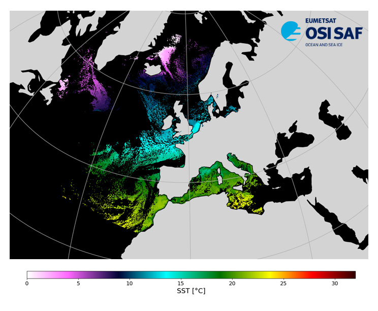
EUMETSAT OSI SAF NOAA-18 North Atlantic Regional Sea Surface Temperature
Level 3, four times a day, sub-skin Sea Surface Temperature derived from AVHRR on Metop satellites and VIIRS or AVHRR on NOAA and NPP satellites, over North Atlantic and European Seas and re-projected on a polar stereographic at 2 km resolution, in GHRSST compliant netCDF format. This catalogue entry presents NOAA-18 North Atlantic Regional Sea Surface Temperature.
SST is retrieved from infrared channels using a multispectral algorithm and a cloud mask. Atmospheric profiles of water vapor and temperature from a numerical weather prediction model, Sea Surface Temperature from an analysis, together with a radiative transfer model, are used to correct the multispectral algorithm for regional and seasonal biases due to changing atmospheric conditions.
The quality of the products is monitored regularly by daily comparison of the satellite estimates against buoy measurements. The product format is compliant with the GHRSST Data Specification (GDS) version 2.Users are advised to use data only with quality levels 3,4 and 5.
Simple
- Date (Creation)
- 2006-01-01T00:36:11.810Z
- Edition
- 1
- Edition date
- 2015-02-02T00:00:00.000Z
- Identifier
- gov.nasa.esdis.umm.shortname / AVHRR_SST_NOAA18_NAR-OSISAF-L3C-v1.0
- Name
- GHRSST Level 3C North Atlantic Regional (NAR) subskin Sea Surface Temperature from SNPP/VIIRS and Metop-A/AVHRR (GDS V2) produced by OSI SAF
- Other citation details
- EUMETSAT/OSI SAF, EUMETSAT Ocean and Sea Ice Satellite Application Facility, Meteo-France/CMS, Lannion, France, 2015-02-02, GHRSST Level 3C North Atlantic Regional (NAR) subskin Sea Surface Temperature from SNPP/VIIRS and Metop-A/AVHRR (GDS V2) produced by OSI SAF, www.osi-saf.org
- Status
- completed Completed
- Access constraints
- unrestricted
- Other constraints
- Open Licence
- Other constraints
- EUMETSAT Ocean and Sea Ice Satellite Application Facility, North Atlantic Regional Sea Surface Temperature (NOAA-18) 2006-2012 OSI-202, doi:10.15770/EUM_SAF_OSI_NRT_2012, data for [extracted period], [extracted domain], accessed [download date] from [distributor/distribution mean]
- Distance
- 0.02 degree
- Metadata language
- English
))
- Geographic identifier
- Europe / North East Atlantic
- Begin date
- 2006-01-01
- End date
- 2012-05-16
- Reference system identifier
- CARTESIAN
- Reference system identifier
- http://www.opengis.net/def/crs/EPSG/0/4326
- Number of dimensions
- 2
Axis Dimensions Properties
Axis Dimensions Properties
- Distribution format
-
-
NetCDF
(
4
)
-
NetCDF
(
4
)
Distributor
- Name
- Format: Not provided
Distributor
- Name
- Format: Not provided
Distributor
- Name
- Format: Not provided MimeType: text/html
Distributor
- Name
- Format: Not provided MimeType: text/html
Distributor
- Name
- Format: Not provided
Distributor
- Name
- Format: Not provided
Distributor
- Name
- Format: Not provided MimeType: text/html
- OnLine resource
- Ifremer HTTP server ( WWW:LINK )
- OnLine resource
-
User guide
(
WWW:LINK
)
Product User Guide
- OnLine resource
- EUMETCast ( WWW:BROADCAST )
- OnLine resource
-
Local path on Datarmor (Ifremer restricted) platform
(
NETWORK:LINK
)
Local path
- Hierarchy level
- Series
Accuracy of time measurement
- Measure identification
- PrecisionOfSeconds
Quantitative result
Content Information
- Attribute description
- 3-min granule
- Content type
- Physical measurement
- gmd:otherProperty
- earliest_granule_start_time Earliest Granule Start Time for dataset. 2013-06-04T05:30:10.000Z latest_granule_end_time Latest Granule Stop/End Time for dataset. 2016-11-22T23:41:33.000Z data_latency Dataset Latency 24 Series Name Dataset citation series name GHRSST Level 3C North Atlantic Regional (NAR) subskin Sea Surface Temperature from SNPP/VIIRS and Metop-A/AVHRR (GDS V2) produced by OSI SAF Persistent ID Dataset Persistent ID PODAAC-GHNMA-3CO02
- Processing level code
- L3C /
Content Information
- File identifier
- 5839a574-b5ff-43fe-a299-0f817ad82cba XML
- Metadata language
- English
- Character set
- UTF8
- Hierarchy level
- Series
- Date stamp
- 2025-11-01T15:21:13.262347Z
- Metadata standard name
- ISO 19115-3:2018 - Remote Sensing
Overviews
Spatial extent
Provided by
