 Catalogue PIGMA
Global Estuary Database (2003)
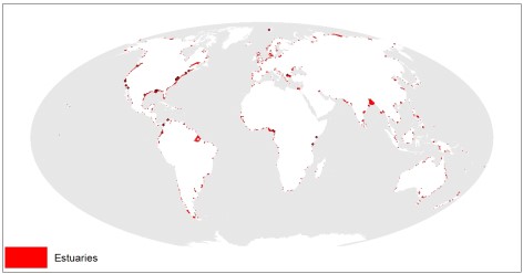
This dataset shows the global distribution of over 1,300 estuaries, including some lagoon systems and fjords. The majority of estuaries are represented by polygons, except for 44 records for which points are available. This dataset was developed by Sea Around Us (www.seaaroundus.org).
Simple
- Date (Publication)
- 2003-01-01
- Identifier
- 5c17c6ac-866c-4747-b5b3-9d6287d5c738
- Purpose
- The global estuary database is the first to be designed at a global scale and the first to include digitized shape cells for each estuary. The dataset was created by Sea Around Us (http://www.seaaroundus.org/).
- Credit
- University of British Columbia (Canada)
- Thèmes Sextant
-
- /Human Activities/Economic Equipment and On-land Techniques/Wastewater Networks/Discharge points
- GEMET - INSPIRE themes, version 1.0
-
- Oceanographic geographical features
- Mission Atlantic - Resources
-
- Data
- Mission Atlantic - BODC Parameters
-
- /Cross-discipline/Fluxes
- Mission Atlantic - Data type (DMP)
-
- Modelling data
- Mission Atlantic - Work Package
-
- WP4 Benthic Mapping
- WP3 Pelagic Mapping
- Mission Atlantic - Case Studies
-
- Atlantic Ocean
- Use limitation
- UNEP-WCMC General Data License
- Access constraints
- Other restrictions
- Use constraints
- Copyright
- Other constraints
- For commercial use, please contact business-support@unep-wcmc.org.
- Spatial representation type
- vector Vector
- Metadata language
- English
- Character set
- utf8 UTF8
- Topic category
-
- Oceans
N
S
E
W
))
- Reference system identifier
- EPSG / WGS 84 (EPSG:4326) / 7.4
- Geometric object type
- Surface
- Distribution format
-
-
ESRI Shapefile
(
1.0
)
-
ESRI Shapefile
(
1.0
)
- OnLine resource
- Access data on Ocean Data Viewer ( WWW:LINK )
- Hierarchy level
- Dataset
- Statement
-
This is a modified version of the 2003 version of the dataset. See 'Creation
methodology' for details.
- File identifier
- 5c17c6ac-866c-4747-b5b3-9d6287d5c738 XML
- Metadata language
- English
- Character set
- UTF8
- Hierarchy level
- Dataset
- Date stamp
- 2025-05-15T22:33:16.005257Z
- Metadata standard name
- ISO 19115-3 - SEXTANT
- Metadata standard version
- 1.0
Point of contact
Ifremer
-
Sextant
ZI Pointe du Diable
,
Plouzane
,
Brittany
,
29280
,
France
https://sextant.ifremer.fr/eng
Overviews
Spatial extent
N
S
E
W
Provided by

Associated resources
Not available