 Catalogue PIGMA
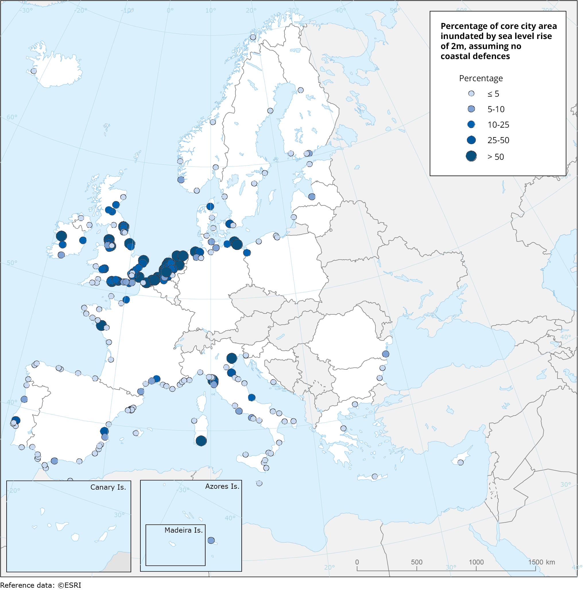
Area inundated with 2m sea level rise, Jan. 2020
This metadata refers to a dataset that shows the percentage of cities' administrative area (core city based on the Urban Morphological Zones dataset) inundated by the sea level rise of 2 metres, without any coastal flooding defences present for a series of individual coastal European cities (included in Urban Audit).
The dataset has been computed using the CReSIS (Centre for Remote Sensing of Ice Sheets) dataset for 2018.
Simple
- Date (Creation)
- 2020-01-15T00:00:00
- Date (Publication)
- 2020-01-21T00:00:00
- Edition
- 01.00
- Identifier
- eea_v_4258_100_k_inundated-area-2m_p_2018_v01_r00
Point of contact
- Maintenance and update frequency
- Not planned
- Keywords
-
- Keywords
-
- GEMET
-
- climate
- climate change impact
- sea level rise
- climate change adaptation
- coastal flooding
- flooding
- city
- Continents, countries, sea regions of the world.
-
- Croatia
- Denmark
- Romania
- Greece
- Netherlands
- Italy
- United Kingdom
- Slovenia
- Ireland
- Germany
- Malta
- Finland
- France
- Estonia
- Iceland
- Sweden
- Spain
- Belgium
- Bulgaria
- Lithuania
- Latvia
- Poland
- Cyprus
- Portugal
- EEA topics
-
- Climate adaptation
- Water
- Sous-regions marines
-
- /Métropole
- /Métropole/Manche mer du Nord
- /Métropole/Mers Celtiques
- /Métropole/Golfe de Gascogne
- /Métropole/Méditerranée occidentale
- Thématiques - SIMM
-
- /Activités et Usages/Analyse économique et sociale
- Thématiques - SIMM
-
- /Activités et Usages/Urbanisation et Artificialisation
- Thématiques - SIMM
-
- /Etat du Milieu/Littoral
- Type de jeux de donnée - ODATIS
-
- /Données dérivées/Produits composites
- Type de jeux de donnée - ODATIS
-
- /Télédétection
Resource constraints
- Access constraints
- Other restrictions
- Use constraints
- Other restrictions
- Other constraints
-
CReSIS (Centre for Remote Sensing of Ice Sheets) 2018, Lawrence, Kansas, USA. Digital Media. http://data.cresis.ku.edu/data.
Eurostat Urban Audit 2018 spatial units: https://ec.europa.eu/eurostat/web/gisco/geodata/reference-data/administrative-units-statistical-units
- Spatial representation type
- vector Vector
- Denominator
- 100000
- Metadata language
- English
- Topic category
-
- Environment
- Climatology, meteorology, atmosphere
- Begin date
- 2018-01-01
- End date
- 2018-12-31
))
- Unique resource identifier
- EPSG:4258
- Distribution format
-
-
SHP
(
)
-
SHP
(
)
- OnLine resource
- https://sdi.eea.europa.eu/webdav/datastore/public/eea_v_4258_100_k_inundated-area-2m_p_2018_v01_r00/ ( EEA:FOLDERPATH )
- OnLine resource
- https://climate-adapt.eea.europa.eu/en/knowledge/tools/urban-adaptation ( WWW:LINK-1.0-http--link )
- OnLine resource
- https://climate.discomap.eea.europa.eu/arcgis/services/UAMV/coastal_inundation_city_area_2m/MapServer/WMSServer?request=GetCapabilities&service=WMS ( OGC:WMS )
- OnLine resource
- https://climate.discomap.eea.europa.eu/arcgis/rest/services/UAMV/coastal_inundation_city_area_2m/MapServer ( ESRI:REST )
- OnLine resource
- Direct download ( WWW:URL )
- Hierarchy level
- Dataset
Domain consistency
Conformance result
- Date (Publication)
- 2010-12-08
- Explanation
- See the referenced specification
- Statement
-
Data on sea level rise was obtained from CReSIS (Centre for Remote Sensing of Ice Sheets) 2018, Lawrence, Kansas, USA. Digital Media. http://data.cresis.ku.edu/.
Coastal city centroids was obtained from Eurostat Urban Audit 2018 spatial units: https://ec.europa.eu/eurostat/web/gisco/geodata/reference-data/administrative-units-statistical-units
Urban Morphological Zone (UMZ) from Urban Atlas 2012. UMZ is the reference unit for the city morphology. They are regarded as the best approximation of the “real” city form and defined as a set of urban areas laying less than 200 m apart, within the core city administrative boundaries.
- File identifier
- d96b007a-4e26-4dbd-8dd5-24dbe5c9b31f XML
- Metadata language
- English
- Character set
- UTF8
- Hierarchy level
- Dataset
- Date stamp
- 2025-10-09T11:17:50.6461Z
- Metadata standard name
- ISO 19115/19139
- Metadata standard version
- 1.0
Overviews
Spatial extent
Provided by
