 Catalogue PIGMA
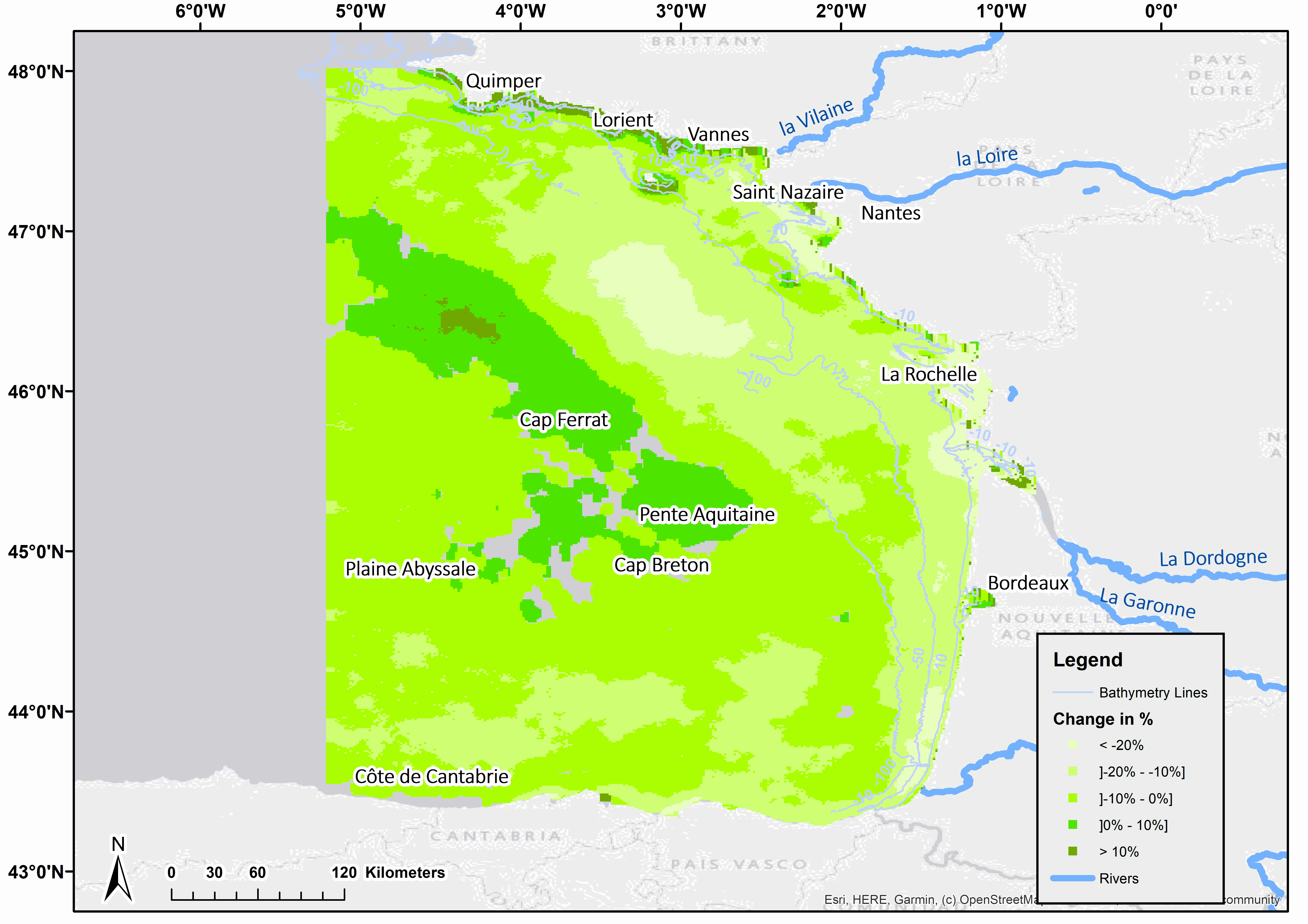
Map of Chlorophyll a concentrations trend between 1998 and 2019 in the Gulf of Biscay
For the 21 years of the study, an examination of trends in chlorophyll concentration revealed a general decline throughout the Gulf over the production period. These trends, extracted from dynamic linear model, also allowed this decline to be quantified. Expressed as a percentage, a large part of the area below the 50 m bathymetric line showed a decrease of at least 10% over the period, corresponding to a value of at least 0.1 µg.l-1. However, the spatial distribution reveals some more local phenomena. In southern Brittany, from Quimper to Vannes, a particular feature appears, with an upward trend over several kilometres along the coast, followed by a pronounced gradient along the coast. This gradient includes a zone where a continuous monotonic increasing trend is observed, then a zone where the trend becomes not significant and finally, about 15 km from the coast, a new zone where a significant continuous monotonic decreasing trend is observed. The increase in chlorophyll a concentration in the very coastal part is greater than 0.1 µg.l-1 over the period. Another peculiarity concerns the central part, located at the edge of the plateau at Cap Ferrat and Pente Aquitaine, where an increase in chlorophyll a was observed, but the variations remained small, being less than 0.1 µg.l-1. About a hundred kilometres south-west of Saint Nazaire, an area of about 40 by 50 km shows a decrease in chlorophyll a of more than 20%, quantified as more than 0.1 µg.l-1 over the period.
Simple
- Date (Publication)
- 2023-11-28
- Date (Revision)
- 2024-06-26
- Other citation details
- Huguet Antoine (2023). Map of Chlorophyll a concentrations trend between 1998 and 2019 in the Gulf of Biscay. SEANOE. https://doi.org/10.17882/98111
- Theme
-
- Chlorophyll a
- dynamic linear model
- satellite time series
- climate change
- Environment
- Use limitation
- CC-BY (Creative Commons - Attribution)
- Use constraints
- Other restrictions
- Metadata language
- English
- Topic category
-
- Oceans
N
S
E
W
))
- Begin date
- 1998-01-01
- End date
- 2019-12-31
- Distribution format
-
-
CSV
(
)
-
CSV
(
)
- OnLine resource
-
Processed data
(
WWW:DOWNLOAD-1.0-link--download
)
CSV file is constituted with 10 fields. Field P.Value is the result of Man kendall test (Yue et Wang), Résultat...VariationUnité is the variation of Chl a expressed in µg/l - 17 MB
- OnLine resource
- DOI of the product ( WWW:LINK-1.0-http--metadata-URL )
- OnLine resource
- Seanoe ( rel-canonical )
- Hierarchy level
- Dataset
- Statement
- Times series have been constituted with daily MODIS satellite data. Chlorophyll a concentrations have been calculated for each pixel with OC5 algorihm (Gohin et al., 2002 ; Gohin, 2011).
- File identifier
- seanoe:98111 XML
- Metadata language
- English
- Character set
- UTF8
- Hierarchy level
- Dataset
- Date stamp
- 2024-06-26
- Metadata standard name
- ISO 19115:2003/19139
- Metadata standard version
- 1.0
Overviews
Spatial extent
N
S
E
W
Provided by

Associated resources
Not available