 Catalogue PIGMA
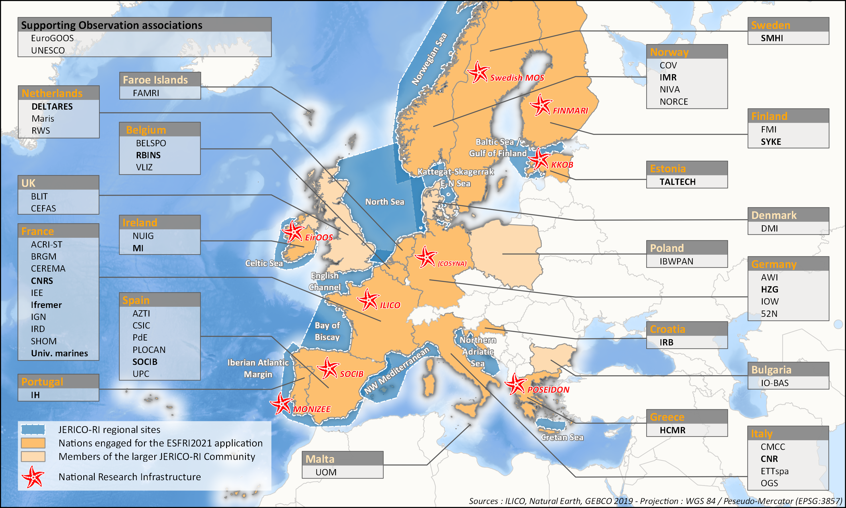
JERICO-RI SURVEY 2020 - Coastal platforms (ongoing work)
aThis survey action has been undertaken as part of WP6 of the H2020 JERICO-S3 project. Its integration in Sextant is the first step towards a comprehensive and extensive data catalog for the JERICO Research Infrastructure.
JERICO-S3, Description of Work - WP6 : Data Management
Task 6.2: Data management for coastal platforms (M1-48) (Lead: HCMR)
Subtask 6.2.1: Identify and update the overview of JERICO-RI involved platforms and data (SMHI, MARIS, IFREMER) (M1-48)
The JERICO dataset catalogue has proven a useful tool for creating an overview of platforms and data relevant for the project this and will be updated. Input from other WP’s will be used to identify the actual JERICO platforms, including the PSS, TNA platforms, and IRS. Partners will collect and describe coastal platforms in the dataset catalogue (technically run in WP7) including pointers to data, which variables (related to EOV’s) published as D6.2.
Subtask 6.2.2: Best practice capturing for “mature” platforms with physical and BGC parameters (HCMR, SMHI, CNR, ETT, SOCIB, HZG, RWS) (M6-42).
For the following platform types there will be activities supporting data management as defined under T6.4 in close relation to the Virtual Research Environment in WP7: HF radars (CNR), Gliders (SOCIB, ETT), FerryBox (HZG) The work for each platform type will follow basically the same approach and will cooperate with WP4 (PSS) and WP3 (IRS). The experts will identify the existing standards, and possible data management best practices (D6.3). At the end of the project an evaluation will be done of the level of Best Practice adoption at the IRSs and PSSs in the project, as well as the use of the VRE by the partners engaged in WP3 and WP4 (D6.10). This will be done in cooperation with WP3 and WP4, and is an important condition for data to be accessible for use in the Virtual Environment in T7.4.
Simple
- Date (Publication)
- 2020-07-08
- Identifier
- FR-330-715-368-00362_IFR_JERICO_STATIONS
- Credit
- JERICO-RI
- Thèmes Sextant
-
- /Human Activities/Coastal monitoring networks
- GEMET - INSPIRE themes, version 1.0
-
- Environmental monitoring facilities
- Use limitation
- CC-BY (Creative Commons - Attribution)
- Access constraints
- Other restrictions
- Use constraints
- Copyright
- Spatial representation type
- vector Vector
- Denominator
- 50000
- Metadata language
- English
- Character set
- utf8 UTF8
- Topic category
-
- Oceans
))
- Unique resource identifier
- EPSG:4326
- Geometric object type
- Complex
- Distribution format
-
-
(
)
-
(
)
- OnLine resource
-
JERICO_STATION_POINT1
(
OGC:WMS
)
JERICO - Station (point)
- OnLine resource
-
JERICO_STATION_POINT1
(
OGC:WFS
)
JERICO - Station (point)
- OnLine resource
-
JERICO_STATION_LINE
(
OGC:WMS
)
JERICO - Station (line)
- OnLine resource
-
JERICO_STATION_LINE
(
OGC:WFS
)
JERICO - Station (line)
- OnLine resource
-
JERICO_STATION_POLYGON
(
OGC:WMS
)
JERICO - Station (polygon)
- OnLine resource
-
JERICO_STATION_POLYGON
(
OGC:WFS
)
JERICO - Station (polygon)
- OnLine resource
-
JERICO_REGIONS
(
OGC:WMS
)
JERICO - Regions
- OnLine resource
-
JERICO_REGIONS
(
OGC:WFS
)
JERICO - Regions
- Hierarchy level
- Dataset
Domain consistency
Conformance result
- Date (Publication)
- 2010-12-08
- Explanation
- See the referenced specification
- File identifier
- 1895eef4-f1ee-4a4c-8e78-1c86e809251d XML
- Metadata language
- English
- Character set
- UTF8
- Hierarchy level
- Dataset
- Date stamp
- 2025-05-15T21:30:13.120709Z
- Metadata standard name
- ISO 19115-3 - SEXTANT
- Metadata standard version
- 1.0
Overviews
Spatial extent
Provided by
