 Catalogue PIGMA
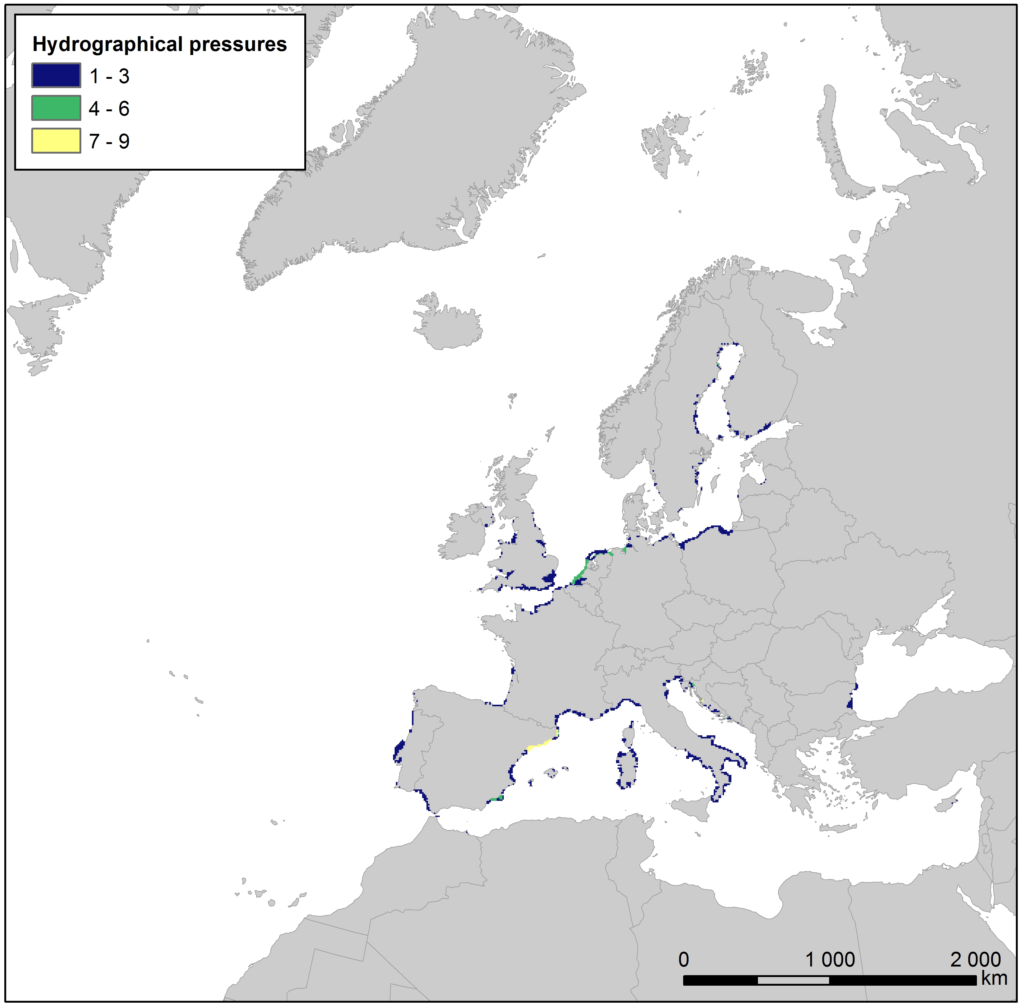
Hydrographical pressure along European coastlines, Jan. 2020
This raster dataset presents the number of different hydrographical pressures per grid cell along the European coastlines. Hydrographical pressures are human activities that cause changes in hydrological conditions, i.e. changes to freshwater input, salinity, seawater flows, waves, currents, and temperature. Examples of such activities include riverine or coastal dams, offshore infrastructure, and outflows from power plants.
The layer has been created using the Water Framework Directive (WFD) reported data on hydrographical pressures joined with the water body polygon features for the reference year 2016. The dataset was then rasterized into the EEA 10 km grid, and the cell values assigned with the number of different hydrographical pressures in the area covered by the cell.
This dataset has been prepared for the calculation of the combined effect index, produced for the ETC/ICM Report 4/2019 "Multiple pressures and their combined effects in Europe's seas" available on: https://www.eionet.europa.eu/etcs/etc-icm/etc-icm-report-4-2019-multiple-pressures-and-their-combined-effects-in-europes-seas-1.
Simple
- Date (Creation)
- 2018-09-01
- Date (Publication)
- 2020-01-27
- Edition
- 01.00
- Identifier
- eea_r_3035_10_km_hydrological-pressure-coastline_p_2016_v01_r00
Point of contact
- Maintenance and update frequency
- As needed
- Keywords
-
- Keywords
-
- GEMET
-
- pressure
- industry
- hydrography
- sea
- Water Framework Directive
- coast
- environmental pressure
- water body
- Continents, countries, sea regions of the world.
-
- English Channel
- Barents Sea
- Norwegian Sea
- Northeast Atlantic Ocean (40W)
- Ionian Sea
- Kattegat
- Adriatic Sea
- Black Sea
- Iceland Sea
- Mediterranean Sea
- Celtic Sea
- Bay of Biscay
- Baltic Sea
- North Sea
- Spatial scope
-
- European
- EEA topics
-
- Seas and coasts
- Water
- Land use
- Sous-regions marines
-
- /Métropole
- /Métropole/Manche mer du Nord
- /Métropole/Mers Celtiques
- /Métropole/Golfe de Gascogne
- /Métropole/Méditerranée occidentale
- Thématiques - SIMM
-
- /Activités et Usages/Industrie et énergie
- Thématiques - SIMM
-
- /Activités et Usages/Urbanisation et Artificialisation
- Thématiques - SIMM
-
- /Etat du Milieu/Hydrodynamique
- Thématiques - SIMM
-
- /Etat du Milieu/Pollutions
- Thématiques - SIMM
-
- /Etat du Milieu/Littoral
- Type de jeux de donnée - ODATIS
-
- /Données dérivées/Produits composites
- Cadre Réglementaire - SIMM
-
- Directive Cadre sur l'Eau (DCE)
- Access constraints
- Other restrictions
- Other constraints
- no limitations to public access
- Use constraints
- Other restrictions
- Other constraints
- License CC-BY 4.0 (https://creativecommons.org/licenses/by/4.0/). Copyright holder: European Environment Agency (EEA).
- Spatial representation type
- grid Grid
- Distance
- 10 km
- Metadata language
- English
- Topic category
-
- Environment
- Oceans
))
- Begin date
- 2016-01-01
- End date
- 2016-12-31
- Unique resource identifier
- EPSG:3035
- Distribution format
-
-
GeoTIFF
(
)
-
GeoTIFF
(
)
- OnLine resource
- https://sdi.eea.europa.eu/webdav/datastore/public/eea_r_3035_10_km_hydrological-pressure-coastline_p_2016_v01_r00/ ( EEA:FOLDERPATH )
- OnLine resource
- Direct download ( WWW:URL )
- OnLine resource
- https://water.discomap.eea.europa.eu/arcgis/rest/services/Marine/Pressures_Hydrographical_pressure/MapServer ( ESRI:REST )
- Hierarchy level
- Dataset
Domain consistency
Conformance result
- Date (Publication)
- 2010-12-08
- Explanation
- See the referenced specification
- Statement
- The dataset was created by joining hydrographical pressures listed in the Water Framework Directive 2016 reporting with spatial data on European water bodies. The WFD data was in table format and listed the total amount of different pressures per water body. The table (i.e. the total amount of pressures) was joined with water body polygon features, downloaded from EEA and Eionet. The polygon features were then converted to the EEA 10 km grid.
- File identifier
- 1d8c8e88-fb95-40f8-b41a-7134aaff2d8a XML
- Metadata language
- English
- Character set
- UTF8
- Hierarchy level
- Dataset
- Date stamp
- 2025-10-09T10:39:23.859838Z
- Metadata standard name
- ISO 19115/19139
- Metadata standard version
- 1.0
Overviews
Spatial extent
Provided by
