 Catalogue PIGMA
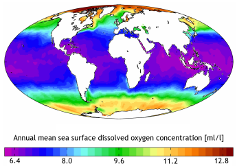
Dissolved oxygen parameters in the water column | Concentration of oxygen {O2 CAS 7782-44-7} per unit volume of the water body [dissolved plus reactive particulate phase] | EMODnet Secretariat | EMODNET - Chemistry - Oxygen datasets
Simple
- Alternate title
- EMODNET - Chemistry - Oxygen datasets
- Date
- Identifier
- Dissolved oxygen parameters in the water column | Concentration of oxygen {O2 CAS 7782-44-7} per unit volume of the water body [dissolved plus reactive particulate phase] | EMODnet Secretariat | EMODNET - Chemistry - Oxygen datasets
- Purpose
- EMODNet Chemistry Dissolved Oxygen Data - Over 1000 platforms with Dissolved Oxygen data in the EMODnet portal in the interested areas
- Status
- onGoing On going
- Maintenance and update frequency
- Continual
- Used by challenges
-
- Atlantic - CH08 - Eutrophication
- Environmental matrix
-
- Marine water
- Production mode
-
- Delayed
- Visibility
-
- Search via reference catalogue (e.g. MyOcean, GEOSS Geoportal…)
- Policy visibility
-
- There is detailed information provided to understand data policy
- Readyness
-
- Format not proprietary and content clearly specified (e.g. autodescriptive like ODV, NetCDF CF) or at least with appropriate document describing the content
- Parameter Discovery Vocabulary (P02)
-
- Dissolved oxygen parameters in the water column
- GEMET - INSPIRE themes, version 1.0
-
- Oceanographic geographical features
- Processing level of characteristics
-
- Observation (raw, QC)
- Data delivery mechanisms
-
- Online discovery + downloading + viewing services (Advanced services)
- Parameter Usage Vocabulary (P01)
-
- Concentration of oxygen {O2 CAS 7782-44-7} per unit volume of the water body [dissolved plus reactive particulate phase]
- Parameter Usage Vocabulary (other)
-
- Concentration of oxygen per unit volume of the water body
- Agreed Parameter Groups (P03)
-
- Dissolved gases
- Service extent
-
- The datasets are provided through an EU Inspire catalogue service (OGC)
- Validation
-
- Submitted
- Access constraints
- Other restrictions
- Other constraints
- Unrestricted
- Use limitation
- Open and Free. No charge
- Spatial representation type
- vector Vector
- Distance
- 10000 meter
- Metadata language
- Français
- Character set
- utf8 UTF8
- Topic category
-
- Oceans
- Environment description
- Potential use of raw data for eutrophication assessment
N
S
E
W
))
- Begin date
- 2005-01-01
Vertical extent
- Minimum value
- 0
- Maximum value
- 1500
- Dimension name
- Time
- Resolution
- 1 day
- Transformation parameter availability
- Yes
- Checkpoint Availability
- Yes
- Distribution format
-
-
ZIP
()
-
Text
()
-
Ascii
()
-
NetCDF
()
-
ZIP
()
- OnLine resource
- EMODNET Chemistry ( WWW:LINK )
- OnLine resource
- Multiple ( WWW:LINK )
- Hierarchy level
- Dataset
Domain consistency
- Name of measure
- Responsiveness
Quantitative result
- Value
- Less or equal to 1 week for release
Domain consistency
- Name of measure
- Reliability
Quantitative result
- Statement
- http://www.seadatanet.org/content/download/3899/29604/version/2/file/SeaDataNet+Data+Policy+.pdf
- Hierarchy level
- datasetComponent
N
S
E
W
))
- Begin date
- 2005-01-01
- End date
- 2014 After
Vertical extent
- Minimum value
- 0
- Maximum value
- 0
- Other
- ATLANTIC_CH08_Product_1
- Other
- Map of seasonal averages of dissolved oxygen indicator for eutrophication in the past 10 years for the Atlantic basin
- Other
- Marine water|Dissolved oxygen parameters in the water column|Concentration of Oxygen per unit mass of the water body|Observation (raw, QC)|Delayed (mandatory)
- Other
- Marine water|Salinity of the water column|Salinity of the water body|Observation (raw, QC)|Delayed (mandatory)
- Other
- Marine water|Temperature of the water column|Temperature of the water body|Observation (raw, QC)|Delayed (mandatory)
Completeness omission
- Name of measure
- Horizontal Spatial Coverage
- Measure identification
- AP.1.1
- Measure description
- Horizontal coverage extent of product (eg : surface of the Mediterranean Sea)
Quantitative result
- Value type
- Real
gmd:DQ_DescriptiveResult
- Date / Time
- 2018-01-26T00:00:00
Completeness omission
- Name of measure
- Vertical Spatial Coverage
- Measure identification
- AP.1.2
- Measure description
- Vertical coverage extent of product
Quantitative result
- Value type
- Real
gmd:DQ_DescriptiveResult
- Date / Time
- 2018-01-26T00:00:00
Completeness omission
- Name of measure
- Temporal Coverage
- Measure identification
- AP.1.3
- Measure description
- Temporal coverage extent of product
Quantitative result
- Value type
- Integer
gmd:DQ_DescriptiveResult
- Date / Time
- 2018-01-26T00:00:00
Completeness omission
- Name of measure
- Number of items
- Measure identification
- AP.1.4
- Measure description
- Count of all items in the dataset or sample. Describe the items which are counted. If the number is determined by sampling unit (density), define the sampling unit (eg size of mesh).
Quantitative result
- Value type
- Integer
gmd:DQ_DescriptiveResult
- Date / Time
- 2018-01-26T00:00:00
Conceptual consistency
- Name of measure
- Number of Characteristics
- Measure identification
- AP.2.1
- Measure description
- Number of characteristics in product
Quantitative result
- Value type
- Integer
gmd:DQ_DescriptiveResult
- Date / Time
- 2018-01-26T00:00:00
Thematic classification correctness
- Name of measure
- Horizontal resolution
- Measure identification
- AP.3.1
- Measure description
- Horizontal mesh size or equivalent value for the given scale of product (eg 50m for 1/50 000)
Quantitative result
- Value type
- Integer
gmd:DQ_DescriptiveResult
- Date / Time
- 2018-01-26T00:00:00
Thematic classification correctness
- Name of measure
- Temporal resolution
- Measure identification
- AP.3.3
- Measure description
- Temporal sampling interval of product
Quantitative result
- Value type
- Real
gmd:DQ_DescriptiveResult
- Date / Time
- 2018-01-26T00:00:00
gmd:DQ_UsabilityElement
- Name of measure
- Usability
- Measure identification
- AP.5.1
gmd:DQ_DescriptiveResult
- Date / Time
- 2018-01-26T00:00:00
- Attribute description
- observation
- Content type
- Physical measurement
- Description
- 1200
- File identifier
- 371b0b26-628f-4641-a725-5c78ae8aa2af XML
- Metadata language
- English
- Character set
- UTF8
- Hierarchy level
- Series
- Hierarchy level name
- Atlantic - CH08 - Eutrophication
- Date stamp
- 2017-05-04T09:22:54Z
- Metadata standard name
- ISO 19115-3 - Emodnet Checkpoint - Upstream Data
- Metadata standard version
- 1.0
Overviews
http://recon.sccf.org/definitions/dissolved_oxygen.shtml
Spatial extent
N
S
E
W
N
S
E
W
Provided by

Associated resources
Not available