 Catalogue PIGMA
Description of the Swell Field Generated by Tropical Cyclones from Multi-Source Wave Observations for ESA MAXSS Project
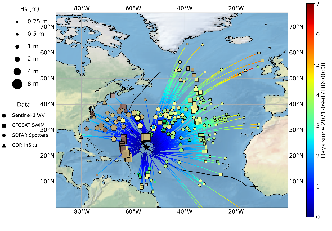
The main objectives of this dataset is to gather the ocean swells measured by different sensors, including satellite and in-situ sources, that were generated by a given tropical cyclone (TC). This dataset aims at providing characteristics of these swells such as their direction, wavelength (or period) and energy but also the date when they left the influence of the tropical cyclone wind to propagate freely.
Wave spectra in tropical cyclones vary strongly per quadrant and provide information about the current and past state of the wave field. However, inside TCs, waves measurements including the wave system direction, energy and wavelength are rare and difficult to obtain with in-situ and remote sensing technics. For this dataset, both moored and drifting buoys are considered as long as they provide wave systems measurements.
For the satellite contribution, Synthetic Aperture Radar (SAR) and real aperture radar (RAR) instruments can significantly contribute to the TC-generated waves documentation. Indeed, ocean wave spectra can be derived from modulations of the backscatter in SAR and RAR signal. SAR on board European satellite and in particular the SAR series developed since ERS-1 by ESA and now ESA/Copernicus with Sentinel-1 mission (S-1) are good candidates to provide these ocean waves systems characteristics thanks to the dedicated acquisition mode : the so-called Wave Mode. The wave spectrometer SWIM developed by the French space Agency (CNES) and embedded on the Chinese-French Oceanography SATellite (CFOSAT) has been launched more recently with a new measurement concept relying on a RAR and can certainly complement the S-1 data collection. Although the reasons are different, these two systems are limited for measuring waves generation area within the TC vortex where strong rain rates and wind regimes are observed. Far enough from their source, satellite acquisitions are thus expected to be able to observe these ocean swells during more favorable met-ocean conditions for waves retrieval inversion. As a consequence, our analysis is focused on waves originating from TC but that have been able to propagate far from their source.
The analysis of swell measurements far from their area of generation to locate the storm source has been firstly applied to data from one single in-situ wave station (wave energy with frequency and direction) collected 2 miles off shore from San Clemente Island, California and extended to a network of several wave stations in the sixties. More recently, the gathering of swell system observed with SAR far from a storm to characterize the waves properties across the ocean has proven to be efficient in the case of extra-tropical storms.
Yet, such analysis is not adapted to Tropical Cyclone whose size is much smaller and currently existing wave datasets do not allow for an accurate monitoring of the tropical cyclones swells. This multi-sensor Level-3 tropical cyclone waves dataset intends to fill this gap and opens for an alternate way of estimating tropical cyclone waves properties over all ocean basins and for all tropical cyclones.
This dataset was produced in the frame of the ESA funded Marine Atmosphere eXtreme Satellite Synergy (MAXSS) project. The primary objective of the ESA Marine Atmosphere eXtreme Satellite Synergy (MAXSS) project is to provide guidance and innovative methodologies to maximize the synergetic use of available Earth Observation data (satellite, in situ) to improve understanding about the multi-scale dynamical characteristics of extreme air-sea interaction.
Simple
- Date (Creation)
- 2023-03-30
- Date (Publication)
- 2023-03-30
- Identifier
- MAXSS-L3-WAVE-TCWAVE / 1.0
- Status
- completed Completed
- Cersat - Parameter
-
- Ocean Waves
- Cersat - Project
-
- MAXSS
- Cersat - Latency
-
- Historical
- Cersat - GCMD parameter
-
- /Ocean Waves/Significant Wave Height
- /Ocean Waves/Swells
- /Ocean Waves/Wave Speed/Direction
- /Ocean Waves/Wave Length
- Centre de données ODATIS
-
- CDS-CERSAT
- Use limitation
- None
- Access constraints
- unrestricted
- Use constraints
- Other restrictions
- Other constraints
- CC-BY (Creative Commons - Attribution)
- Other constraints
- Pouplin C, Mouche A, Chapon B. Ifremer / LOPS. 2023. Description of the Swell Field Generated by Tropical Cyclones from Multi-Source Wave Observations (v1.0) for ESA Marine Atmosphere eXtreme Satellite Synergy project (MAXSS). Ver. 1.0. Ifremer, Plouzane, France. Dataset accessed [YYYY-MM-DD].
- Spatial representation type
- grid Grid
- Topic category
-
- Oceans
))
- Geographic identifier
- Global
- Begin date
- 2015-01-01
- End date
- 2021-12-31
- Reference system identifier
- http://www.opengis.net/def/crs/EPSG/0/4326
- Distribution format
-
-
NetCDF
(
4
)
-
NetCDF
(
4
)
- OnLine resource
- Ifremer HTTPS server ( WWW:LINK )
- OnLine resource
-
Ifremer FTP server
(
WWW:FTP
)
FTP
- OnLine resource
-
Local path on Datarmor
(
NETWORK:LINK
)
Local path
- OnLine resource
- Digital Object Identifier (DOI) ( DOI )
- Hierarchy level
- Dataset
- Attribute description
- composite
- Processing level code
- L3 /
- File identifier
- 54766b9b-d390-4cb8-b39e-98a7cb6933ba XML
- Metadata language
- English
- Character set
- UTF8
- Hierarchy level
- Dataset
- Date stamp
- 2025-12-10T10:14:34.022731Z
- Metadata standard name
- ISO 19115-3:2018 - Remote Sensing
Overviews
Spatial extent
Provided by
