 Catalogue PIGMA
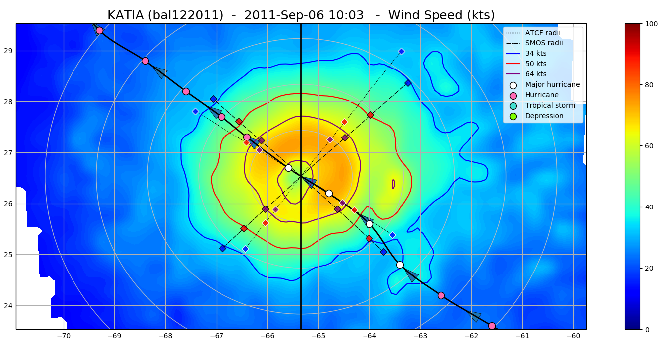
Tropical Cyclone Wind Radii Fixes Dataset for SMOS WIND Project
The SMOS WRF product is available in Near Real Time to support tropical cyclones (TC) forecasts.
It is generated within 4 to 6 hours from sensing from the SMOS L2 swath wind speed products (SMOS L2WS NRT), in the so-called "Fix (F-deck)" format compatible with the US Navy's ATCF (Automated Tropical Cyclone Forecasting) System.
The SMOS WRF "fixes" to the best-track forecasts contain : the SMOS 10-min maximum-sustained winds (in knots) and wind radii (in nautical miles) for the 34 kt (17 m/s), 50 kt (25 m/s) and 64 kt (33 m/s) winds per geographical storm quadrants, and for each SMOS pass intercepting a TC in all the active ocean basins.
See the complete description the "SMOS Wind Data Service Product Description Document" ( http://www.smosstorm.org/Document-tools/SMOS-Wind-Data-Service-Documentation ).
Simple
- Date (Creation)
- 2023-06-20
- Date (Publication)
- 2023-11-23
- Identifier
- CER_L4_WND_GLO_025_SMOS_SMOSWIND / 1.0
- Status
- final final
- GEMET - INSPIRE themes, version 1.0
-
- Oceanographic geographical features
- Cersat - Parameter
-
- Ocean Winds
- Cersat - Project
-
- SMOS Storm
- Cersat - Latency
-
- Historical
- Cersat - GCMD parameter
-
- /Ocean Circulation/Fronts
- /Marine Environment Monitoring
- /Ocean Winds/Surface Winds
- Centre de données ODATIS
-
- CDS-CERSAT
- Type de jeux de donnée ODATIS
-
- /Observational data/satellite
- Use limitation
- None
- Access constraints
- unrestricted
- Use constraints
- Other restrictions
- Other constraints
- CC-BY (Creative Commons - Attribution)
- Other constraints
-
Near-Real Time Surface Wind Speed from SMOS satellite and ancillary data on a 0.25 degree resolution grid.
These data were obtained from the ESA-IFREMER-ODL SMOS Wind NRT Data Service project. Dataset accessed [YYYY-MM-DD]. DOI : 10.12770/6346cd83-026a-4bf4-b57d-1ef04de40324
- Spatial representation type
- grid Grid
- Distance
- 25 km
- Topic category
-
- Oceans
))
- Geographic identifier
- Global
- Begin date
- 2018-05-01
- Distribution format
-
-
NetCDF 4
(
)
-
NetCDF 4
(
)
OnLine resource
- OnLine resource
-
User guide
(
WWW:LINK
)
Esa reference portal
- OnLine resource
- Digital Object Identifier (DOI) ( DOI )
- Hierarchy level
- Dataset
- Attribute description
- pass
- Processing level code
- L4 /
- File identifier
- 6346cd83-026a-4bf4-b57d-1ef04de40324 XML
- Metadata language
- English
- Character set
- UTF8
- Hierarchy level
- Dataset
- Date stamp
- 2024-10-15T15:00:23.729142Z
- Metadata standard name
- ISO 19115-3:2018 - Remote Sensing
Overviews
Spatial extent
Provided by
