 Catalogue PIGMA
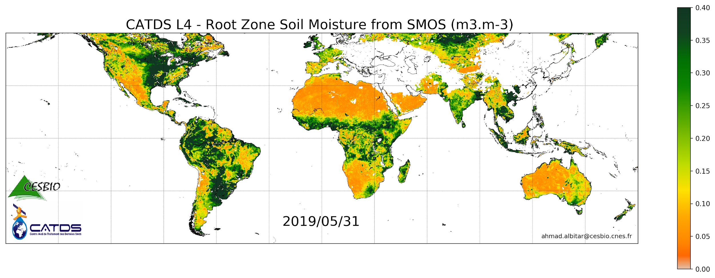
CATDS-PDC L4SM RZSM - 1 day global map of root zone soil moisture values from SMOS satellite
This product is a daily product of root zone soil moisture representative of the 0-1 m depth of the soil.
The base products, for all the CATDS-PDC (Centre Aval de Traitement des Données SMOS - Production & Dissemination Center) processing chains, are the SMOS L1B products from ESA (European Space Agency).
The L4SM RZSM is the daily product of root zone soil moisture (m3/m3) representative of the 0-1 m depth of the soil. The product contains also a quality index taking into account the presence of Radio Frequency Interference (RFI), low quality of retrieval of the input surface soil moisture, and a high fraction of non-nominal surfaces.
Products from reprocessing RE07 are available for the period 01/2010 - 05/2021. Products from operational (OPER) processing are available since 06/2021. Reprocessed products and operational products are derived using the same algorithm and configuration, hence ensuring the temporal continuity.
Simple
- Date (Publication)
- 2022-12-07
- Identifier
- CATDS-PDC_L4SM_RZSM
- Version
- 339
- Credit
- CATDS (CNES, IFREMER, CESBIO)
- Status
- onGoing On going
- GEMET - INSPIRE themes, version 1.0
-
- Oceanographic geographical features
- Cersat - Project
-
- SMOS
- CATDS
- Cersat - Latency
-
- Less than 24 hours
- Centre de données ODATIS
-
- CDS-SAT-CERSAT
- Type de jeux de donnée ODATIS
-
- /Observational data/satellite
- Thèmes Sextant
-
- /Imagery/Satellite Imagery
- GEMET - INSPIRE themes, version 1.0
-
- Orthoimagery
- Theme
-
- SMOS
- CATDS
- CPDC
- L3SM
- Soil Moisture
- Filtered
- Land Product
- RZSM
- Root Zone Soil Moisture
- Access constraints
- OtherRestrictions
- Use constraints
- Product developed by Ifremer/CERSAT and funded in the frame of GMES MyOcean project. Authors : Emmanuelle Autret (eautret@ifremer.fr), Jean-François Piollé (jfpiolle@ifremer.fr)
- Other constraints
- CC-BY (Creative Commons - Attribution)
- Other constraints
- CATDS (2022). CATDS-PDC L4SM RZSM - 1 day global map of root zone soil moisture values from SMOS satellite. CATDS (CNES, IFREMER, CESBIO). https://doi.org/10.12770/316e77af-cb72-4312-96a3-3011cc5068d4. Dataset accessed [YYYY-MM-DD];
- Spatial representation type
- grid Grid
- Denominator
- 1
- Distance
- 25 km
- Metadata language
- English
- Character set
- utf8 UTF8
- Topic category
-
- Geoscientific information
))
- Begin date
- 2010-01-17
- Reference system identifier
- EPSG / WGS 84 / NSIDC EASE-Grid 2.0 Global (EPSG:6933) / 8.6
- Reference system identifier
- http://www.opengis.net/def/crs/EPSG/0/6933
- Number of dimensions
- 3
- Dimension name
- Column
- Dimension size
- 1388
- Dimension name
- Vertical
- Dimension size
- 584
- Dimension name
- Sample
- Dimension size
- 14
- Cell geometry
- Area
- Transformation parameter availability
- No
- Distribution format
-
-
NetCDF
(
netcdf 3 with 64 bit offset option
)
-
NetCDF
(
netcdf 3 with 64 bit offset option
)
- OnLine resource
-
FTP Access
(
WWW:DOWNLOAD
)
FTP Access - All products are also available by ftp : server ftp.ifremer.fr, login ext-catds-cpdc, passwd catds2010, path Land_products/GRIDDED/... (same paths as in above https links)
- OnLine resource
-
Processing and validation
(
WWW:LINK
)
Al Bitar Ahmad, & Mahmoodi Ali. (2020, November 30). Algorithm Theoretical Basis Document (ATBD) for the SMOS Level 4 Root Zone Soil Moisture (Version v30_01). Zenodo. http://doi.org/10.5281/zenodo.4298572
- OnLine resource
- Ifremer HTTPS Access ( WWW:LINK )
- OnLine resource
-
Ifremer FTP Access
(
WWW:FTP
)
FTP
- OnLine resource
-
Product notices
(
WWW:LINK
)
List of products, user manuals and algorithms documents:
- OnLine resource
- Digital Object Identifier (DOI) ( DOI )
- Hierarchy level
- Dataset
- Attribute description
- composite
- Processing level code
- L4 /
- File identifier
- 747f6a18-c158-40f9-800e-6a62c2e493ab XML
- Metadata language
- English
- Character set
- UTF8
- Hierarchy level
- Dataset
- Date stamp
- 2023-12-08T12:20:56.547Z
- Metadata standard name
- ISO 19115-3:2018 - Remote Sensing
- Metadata standard version
- 1.0
Overviews
Spatial extent
Provided by
