 Catalogue PIGMA
Assessment of eutrophication status in European seas using HEAT+, May 2019
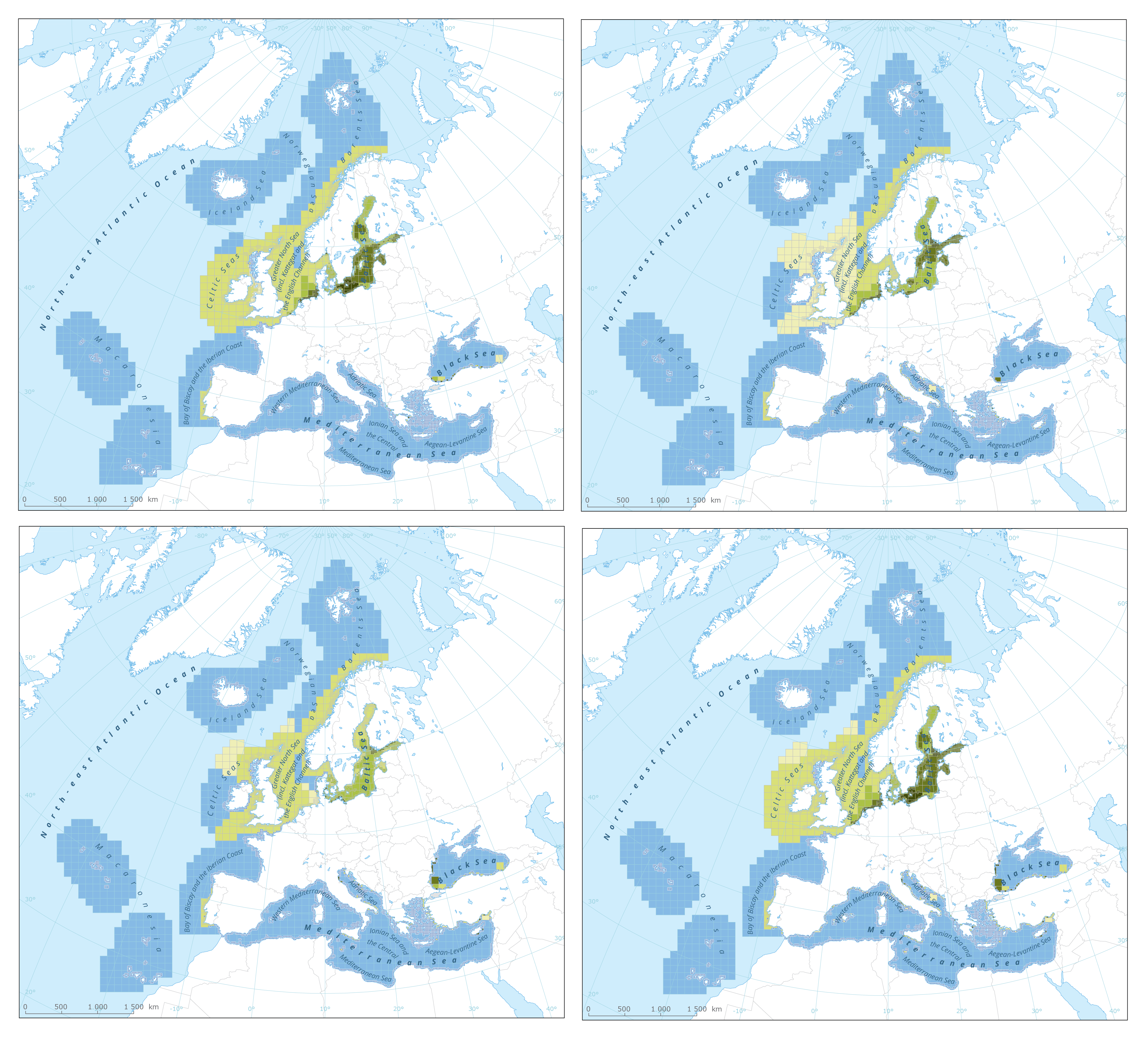
The dataset presents the results of classification of eutrophication status of the European seas using the HEAT+ tool. Eutrophication status is evaluated in five classes, where NPAhigh and NPAgood are recognised as ‘non-problem areas’ and PAmoderate, PApoor and PAbad are recognised as ‘problem areas’.
Besides the overall Eutrophication status (HEAT+) are the results shown for three aspects of eutrophication:
C1) Nutrient Concentrations
C2) Direct Effects
C3) Indirect Effects
This dataset underpins the findings and cartographic representations published in the report "Nutrient enrichment and eutrophication in Europe's seas" (EEA, 2019): https://www.eea.europa.eu/publications/nutrient-enrichment-and-eutrophication-in.
Simple
- Date (Creation)
- 2019-05-08
- Date (Publication)
- 2020-01-13
- Edition
- 01.00
- Identifier
- eea_v_3035_20_km_heat-eutrophication_p_2006-2016_v01_r00
- Identifier
- DAT-217-en
Point of contact
- Maintenance and update frequency
- As needed
- Keywords
-
- Keywords
-
- GEMET
-
- sea water
- ecological status
- marine environment
- nutrient content
- eutrophication
- environmental quality
- contamination
- nutrient balance
- sea
- Continents, countries, sea regions of the world.
-
- Norwegian Sea
- Barents Sea
- Black Sea
- Iceland Sea
- Mediterranean Sea, Western Basin
- Ionian Sea
- Bay of Biscay
- Aegean Sea
- Celtic Sea
- English Channel
- Adriatic Sea
- Mediterranean Sea
- Kattegat
- Baltic Sea
- Mediterranean Sea, Eastern Basin
- Spatial scope
-
- European
- EEA Management Plan
-
- 2019 1.6.2
- EEA topics
-
- Seas and coasts
- Water
- Biodiversity
- Sous-regions marines
-
- /Métropole
- /Métropole/Manche mer du Nord
- /Métropole/Mers Celtiques
- /Métropole/Golfe de Gascogne
- /Métropole/Méditerranée occidentale
- Thématiques - SIMM
-
- /Etat du Milieu/Habitats
- Thématiques - SIMM
-
- /Etat du Milieu/Pollutions
- Type de jeux de donnée - ODATIS
-
- /Données dérivées/Indicateurs
- Type de jeux de donnée - ODATIS
-
- /Données dérivées/Produits composites
- Cadre Réglementaire - SIMM
-
- Directive Cadre Stratégie pour le Milieu Marin (DCSMM)
- Cadre Réglementaire - SIMM
-
- Directive Cadre sur l'Eau (DCE)
- Access constraints
- Other restrictions
- Other constraints
- no limitations to public access
- Use constraints
- Other restrictions
- Other constraints
- License CC-BY 4.0 (https://creativecommons.org/licenses/by/4.0/). Copyright holder: European Environment Agency (EEA).
- Aggregate Datasetindentifier
- 3feffd63-ab0b-4f03-84e8-b2c324c93bbe
- Association Type
- Cross reference
- Aggregate Datasetindentifier
- 2bf95800-8b2e-4edf-9a45-05860300f002
- Association Type
- Cross reference
- Aggregate Datasetindentifier
- fc018b57-05ba-4692-b96b-809983a3a983
- Association Type
- Cross reference
- Aggregate Datasetindentifier
- 5d2e8632-245e-41ad-9a7b-be78f4f4597d
- Association Type
- Cross reference
- Aggregate Datasetindentifier
- 0f5f5180-8546-4bc9-979f-3039e850f23a
- Association Type
- Cross reference
- Aggregate Datasetindentifier
- dfe9061b-84ad-4ef1-ba83-519ab61ebb40
- Association Type
- Cross reference
- Aggregate Datasetindentifier
- 49eb412e-3002-492c-8323-ab5cac07fc40
- Association Type
- Cross reference
- Aggregate Datasetindentifier
- e542e9a1-715a-48e2-8c6c-d8a30541ca93
- Association Type
- Cross reference
- Aggregate Datasetindentifier
- cd87cd22-0a6f-499b-9e27-9691e6e46030
- Association Type
- Cross reference
- Spatial representation type
- vector Vector
- Distance
- 20 km
- Distance
- 100 km
- Metadata language
- English
- Topic category
-
- Environment
))
- Begin date
- 2006-01-01
- End date
- 2016-12-31
- Unique resource identifier
- EPSG:3035
- Distribution format
-
-
SHP
(
)
-
SHP
(
)
- OnLine resource
- https://sdi.eea.europa.eu/webdav/datastore/public/eea_v_3035_20_km_heat-eutrophication_p_2006-2016_v01_r00/ ( EEA:FOLDERPATH )
- OnLine resource
- Direct download ( WWW:URL )
- OnLine resource
-
EEA website - graphic
(
WWW:LINK-1.0-http--link
)
HEAT+ based classifications of 'direct effects' of eutrophication
- OnLine resource
-
EEA website - graphic
(
WWW:LINK-1.0-http--link
)
HEAT+ based classification of 'nutrient concentration levels'
- OnLine resource
-
EEA website - graphic
(
WWW:LINK-1.0-http--link
)
HEAT+ based classifications of 'indirect effects' of eutrophication
- OnLine resource
-
EEA website - graphic
(
WWW:LINK-1.0-http--link
)
Integrated HEAT+ based classifications of 'eutrophication status'
- OnLine resource
- https://water.discomap.eea.europa.eu/arcgis/rest/services/Marine/HEAT_Eutrophication/MapServer ( ESRI:REST )
- OnLine resource
- WMS ( OGC:WMS )
- Hierarchy level
- Dataset
Conformance result
- Date (Publication)
- 2010-12-08
- Explanation
- See the referenced specification
- Statement
-
Results of classification of Eutrophication Status using the HEAT+ tool. Eutrophication status is evaluated in five classes:
NPAhigh and NPAgood are recognised as ‘non-problem areas’
PAmoderate, PApoor and PAbad are recognised as ‘problem areas’
The results are shown for 3 aspects of eutrophication:
C1) Nutrient Concentrations
C2) Direct Effects
C3) Indirect Effects
All results are summed up in the layer HEAT+) the overall Eutrophication status
More information can be found in the report "Contaminants in Europe's seas" and online material on https://www.eea.europa.eu/publications/contaminants-in-europes-seas/.
- File identifier
- 7c66cfd5-4246-4b9d-86af-624950aa49d4 XML
- Metadata language
- English
- Character set
- UTF8
- Hierarchy level
- Dataset
- Date stamp
- 2025-10-09T10:59:27.516976Z
- Metadata standard name
- ISO 19115/19139
- Metadata standard version
- 1.0
Overviews
Spatial extent
Provided by
