 Catalogue PIGMA
EMODnet Human Activities, Oil and Gas, Offshore Installations
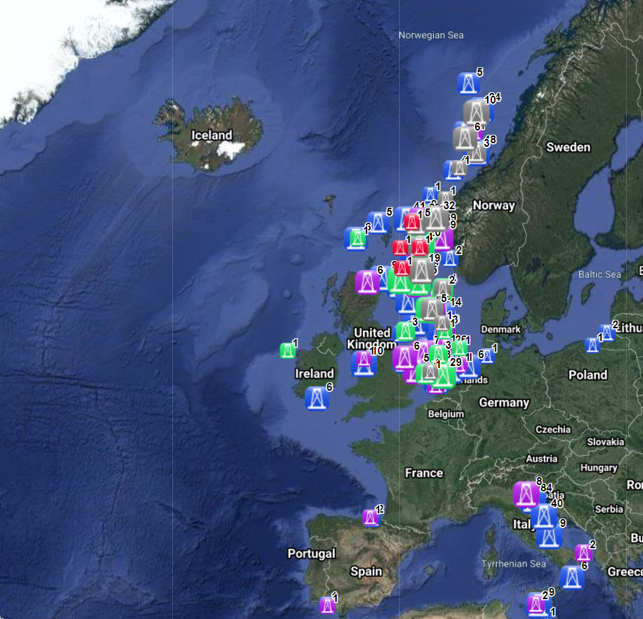
The dataset on offshore installations for Oil and Gas exploitation and exploration activities was created in 2015 by Cogea for the European Marine Observation and Data Network (EMODnet). It is the result of the aggregation and harmonization of datasets provided by several EU and non-EU sources. It is updated every year, and is available for viewing and download on EMODnet - Human Activities web portal (www.emodnet-humanactivities.eu). The dataset contains points representing offshore installations and where available each point has the following attributes: ID, name, country, location block, operator, production start year, primary production, current status, category and function of the installation, sub-structure and topside weights (tonnes), water depth (metres), distance to coast (metres) and remarks. The OSPAR commission source covers data for Germany, Ireland, Spain and the United Kingdom, while for Italy data have been collected and harmonized from the Italian Ministry of Economic Development, for Norway from the Norwegian Petroleum Directorate, for Denmark from the Danish Energy Agency, for the Netherlands from the TNO - Geological Survey of the Netherlands, for Croatia from the Croatian Hydrocarbon Agency, from Marine Traffic and Helcom data on Polish and Russian installations in the Baltic Sea, from Marine Traffic data on Bulgarian, Russian and Ukrainian installations in the Black Sea, Lybian and Spanish installations in the Mediterranean Sea. Compared with the previous version this new version has been updated for all countries.
Simple
- Date (Publication)
- 2015-08-14
- Date (Revision)
- 2020-10-21
- Date (Creation)
- 2015-08-06
- Identifier
- EMODnet_HA_OG_Offshore_Installations_20201021
- Credit
- European Marine Observation and Data Network
Resource provider
Italy - Ministero dello Sviluppo Economico - Direzione Generale per le risorse Minerarie ed Energetiche
- GEMET - INSPIRE themes, version 1.0
-
- Energy resources
- GEMET - Themes, version 2.4
-
- energy
- GEMET - Concepts, version 3.1
-
- hydrocarbon
- oil exploration
- oil extraction
- offshore drilling
- oil production (chain)
- petroleum industry
- Mission Atlantic - Resources
-
- Data
- Mission Atlantic - Case Studies
-
- Celtic Seas
- Mission Atlantic - Work Package
-
- WP3 Pelagic Mapping
- WP4 Benthic Mapping
- Mission Atlantic - Data type (DMP)
-
- Spatial data products
- Mission Atlantic - BODC Parameters
-
- /Human activities/Hydrocarbon extraction
- Use limitation
- Re-use of content for commercial or non-commercial purposes is permitted free of charge, provided that the sources (both EMODnet - Human Activities, and primary sources) are acknowledged. EMODnet - Human Activities accepts no responsibility or liability whatsoever for the re-use of content accessible on its website. Please note that OSPAR data sets retrieved from www.ospar.org may be used for any purpose whatsoever unchanged and in whole, provided: a. OSPAR is identified as the (and as the case may be, partial) source; b. no representation is made of OSPAR having in any way endorsed the purpose of using OSPAR’s data set(s) concerned; c. the user 1 complies to the sublicence particulars listed in OSPAR’s metadata catalogue for the data set(s) concerned, in cases where this concerns data set(s) that OSPAR avails of under third party licence; d. data set(s) are not to be redistributed, in part or in whole. Where distribution is deemed necessary third parties should be referred to www.ospar.org.
- Access constraints
- Other restrictions
- Other constraints
- no limitation
- Denominator
- 100000
- Metadata language
- EnglishEnglish
- Topic category
-
- Utilities communication
N
S
E
W
))
- Distribution format
-
-
ESRI Shapefile
(
1.0
)
-
ESRI Shapefile
(
1.0
)
- OnLine resource
- http://www.emodnet-humanactivities.eu ( WWW:LINK )
- OnLine resource
- Data access ( WWW:LINK )
- Hierarchy level
- Dataset
Conformance result
- Date (Publication)
- 2008-12-04
- Explanation
- See the referenced specification
- Pass
- Yes
Conformance result
- Date (Publication)
- 2010-12-08
- Explanation
- See the referenced specification
Conformance result
- Date (Publication)
- 2009-12-15
- Explanation
- See the referenced specification
- Pass
- Yes
- Statement
- Data were retrived from 8 different sources. Validation and quality assurance remain up to primary data sources, while harmonization is carried out by Cogea. The harmonisation process consisted of identifying a set of attributes common to all the different datasets, thus creating a single data model based on the OSPAR's one. To do so, it was necessary to define a homogenous set of variables for each attribute. Therefore, raw data attributes may use a different terminology, although the information contained remains basically the same. For further information on validation and quality assurance, it is suggested that primary data sources are contacted. Generally speaking data are to be considered very reliable, because they come from national sources officially in charge for their collection. The distance to coast (EEA coastline shapefile) has been calculated using the original data map projections, where available. In the other cases it was used the UTM WGS84 Zone projected coordinate system where data fall in.
Overviews
Spatial extent
N
S
E
W
Provided by

Associated resources
Not available