 Catalogue PIGMA
1338_LINOSA ISLAND
Systematic survey performed by ITS MAGNAGHI with Multibeam EchoSounder Elac 1050
Simple
- Date (Creation)
- Date (Revision)
- Identifier
- LINOSA ISLAND
Originator
Italian Navy Hydrographic Office
+39 010 261400
http://www.marina.difesa.it
Passo Osservatorio, 4
,
Genova
,
16134
,
Italy
+39 010 24431
+39 010 261400
http://www.marina.difesa.it
Custodian
Italian Navy Hydrographic Office
+39 010 261400
http://www.marina.difesa.it
Passo Osservatorio, 4
,
Genova
,
16134
,
Italy
+39 010 24431
+39 010 261400
http://www.marina.difesa.it
- Parameter Discovery Vocabulary (P02)
-
- Bathymetry and Elevation
- SeaDataNet device categories
-
- multi-beam echosounders
- Positioning devices
-
- Differential Global Positioning System receivers
- SeaDataNet depth measurement reference planes
-
- mean low water springs
- Project name
-
- EMODnet HRSM
- Thèmes Sextant
-
- /Physical Environment/Bathymetry/Digital Terrain Model
- GEMET - INSPIRE themes, version 1.0
-
- Elevation
- Access constraints
- by negotiation
- Use constraints
- by negotiation
- Other constraints
- Not for navigation
- Spatial representation type
- Grid
- Denominator
- 10000
- Distance
- 0.03125 Arc minute
- Metadata language
- English
- Character set
- UTF8
- Topic category
-
- Oceans
- Begin date
- 2009-07-15
- End date
- 2009-07-16
Vertical extent
- Minimum value
- 37
- Maximum value
- 1012
- Reference system identifier
- EPSG / WGS 84 (EPSG:4326) / 7.4
- Number of dimensions
- 3
- Dimension name
- Column
- Dimension size
- 256
- Dimension name
- Row
- Dimension size
- 256
- Dimension name
- Time
- Dimension size
- 1
- Cell geometry
- Point
- Transformation parameter availability
- No
- Checkpoint Availability
- No
- Point in Pixel
-
- Upper left
- Distribution format
-
-
(
)
-
(
)
- Hierarchy level
- Dataset
Conformance result
- Date
- Pass
- No
Quantitative attribute accuracy
- Name of measure
- depth
- Measure identification
- depth accuracy
Quantitative result
- Value
- not defined
Gridded data positional accuracy
- Name of measure
- horizontal accuracy
- Measure identification
- horizontal accuracy of coordinate
Quantitative result
- Value type
- horizontal accuracy
Absolute external positional accuracy
- Name of measure
- emodnet-bathymetry.QI.Horizontal
- Value
- 3 - < 20 m
Absolute external positional accuracy
- Name of measure
- emodnet-bathymetry.QI.Vertical
- Value
- 4 - MBES High frequency (higher that 100kHz) (1+0.5%d)
Domain consistency
- Name of measure
- emodnet-bathymetry.QI.Purpose
- Value
- 2 - Bathymetric/morphologic survey
- Hierarchy level
- Software
- Other
- software
- Hierarchy level
- Property type
- Description
- parameters of data processing
- Other
- data processing details
- Statement
- “EMODnet processing methodology using Globe software”
- Description
- IIM_9042
- File identifier
- SDN_CPRD_1338_LINOSA ISLAND XML
- Metadata language
- English
- Character set
- UTF8
- Hierarchy level
- Dataset
- Hierarchy level name
- Composite Product Record
- Date stamp
- 2020-05-26T12:28:47
- Metadata standard name
- ISO 19115:2003/19139 - EMODNET - BATHYMETRY
- Metadata standard version
- 1.0
Author
Italian Navy Hydrographic Office
+39 010 261400
http://www.marina.difesa.it
Passo Osservatorio, 4
,
Genova
,
16134
,
Italy
+39 010 24431
+39 010 261400
http://www.marina.difesa.it
Overviews
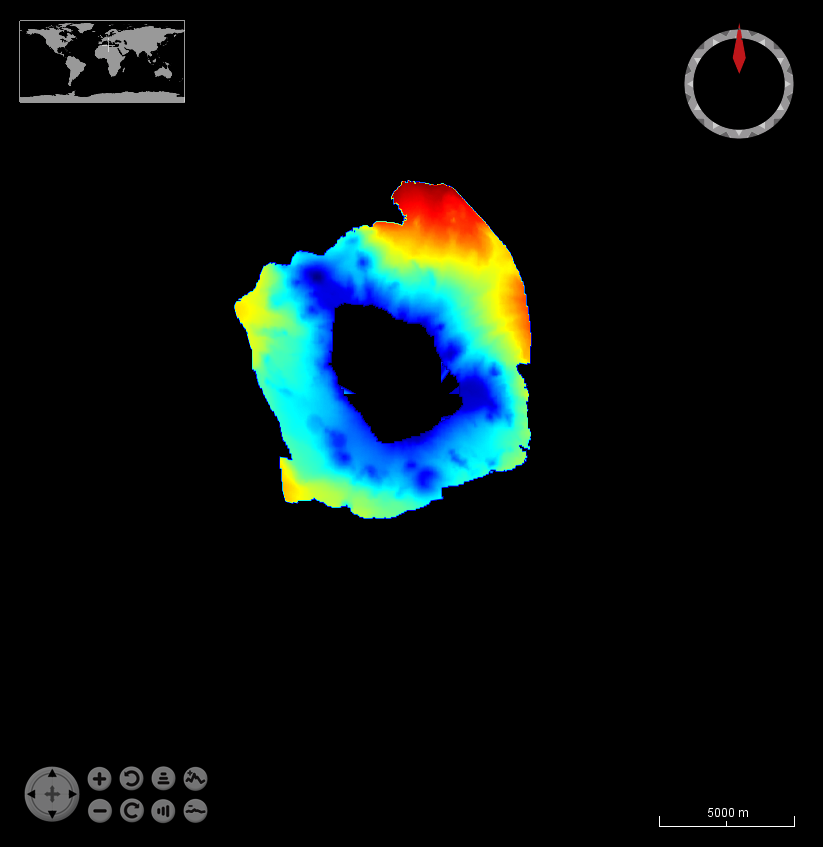
LINOSA%20ISLAND.png
Spatial extent
Provided by

Associated resources
Not available