 Catalogue PIGMA
1338_SOUTH CALABRIA
Systematic survey performed by ITS MAGNAGHI with Multibeam EchoSounder
Simple
- Date (Creation)
- 2018-10-25T00:00:00
- Date (Revision)
- 2018-10-25T00:00:00
- Identifier
- SOUTH_CALABRIA
Originator
Italian Navy Hydrographic Office
+39 010 261400
http://www.marina.difesa.it
Passo Osservatorio, 4
,
Genova
,
16134
,
Italy
+39 010 24431
+39 010 261400
http://www.marina.difesa.it
Point of contact
No information provided.
Custodian
Italian Navy Hydrographic Office
+39 010 261400
http://www.marina.difesa.it
Passo Osservatorio, 4
,
Genova
,
16134
,
Italy
+39 010 24431
+39 010 261400
http://www.marina.difesa.it
- Parameter Discovery Vocabulary (P02)
-
- Bathymetry and Elevation
- SeaDataNet device categories
-
- multi-beam echosounders
- Positioning devices
-
- Differential Global Positioning System receivers
- SeaDataNet depth measurement reference planes
-
- mean low water springs
- Project name
-
- EMODnet HRSM
- Thèmes Sextant
-
- /Physical Environment/Bathymetry/Digital Terrain Model
- Access constraints
- Creative Commons Attribution 4.0 International
- Use constraints
- Other restrictions
- Other constraints
- DO NOT USE FOR NAVIGATION
- Spatial representation type
- Grid
- Denominator
- 100000
- Distance
- 0.03125 Arc minute
- Metadata language
- English
- Character set
- UTF8
- Topic category
-
- Oceans
- Begin date
- 2003-07-15
- End date
- 2003-07-30
Vertical extent
- Minimum value
- 146
- Maximum value
- 2173
N
S
E
W
))
- Reference system identifier
- EPSG / WGS 84 (EPSG:4326) / 7.4
- Number of dimensions
- 3
- Dimension name
- Column
- Dimension size
- 1344
- Dimension name
- Row
- Dimension size
- 1233
- Dimension name
- Time
- Dimension size
- 1
- Cell geometry
- Point
- Transformation parameter availability
- No
- Checkpoint Availability
- No
- Point in Pixel
-
- Lower left
- Distribution format
-
-
(
)
-
(
)
Distributor
Italian Navy Hydrographic Office
+39 010 261400
http://www.marina.difesa.it
Passo Osservatorio, 4
,
Genova
,
16134
,
Italy
+39 010 24431
+39 010 261400
http://www.marina.difesa.it
- OnLine resource
-
SOUTH_CALABRIA - Format EMO
(
WWW:DOWNLOAD
)
SOUTH_CALABRIA - Format EMO
- OnLine resource
- EMODnet Bathymetry WMTS service ( WWW:LINK )
- OnLine resource
- EMODnet viewer ( WWW:LINK )
- Hierarchy level
- Dataset
Conformance result
- Date
- Pass
- No
Quantitative attribute accuracy
- Name of measure
- depth
- Measure identification
- depth accuracy
Quantitative result
- Value
- not defined
Gridded data positional accuracy
- Name of measure
- horizontal accuracy
- Measure identification
- horizontal accuracy of coordinate
Quantitative result
- Value type
- horizontal accuracy
Absolute external positional accuracy
- Name of measure
- emodnet-bathymetry.QI.Horizontal
- Value
- 2 - Between 50 m and 20 m
Absolute external positional accuracy
- Name of measure
- emodnet-bathymetry.QI.Vertical
- Value
- 2 - MBES low frequency (lower than 100kHz) (similar than 1+2%d)
Domain consistency
- Name of measure
- emodnet-bathymetry.QI.Purpose
- Value
- 2 - Bathymetric/morphologic survey
- Hierarchy level
- Software
- Other
- software
- Hierarchy level
- Property type
- Description
- parameters of data processing
- Statement
- EMODnet processing methodology using Globe software”
- Description
- IIM_8963-2A;IIM_8963-2B
- File identifier
- SDN_CPRD_1338_SOUTH_CALABRIA XML
- Metadata language
- English
- Character set
- UTF8
- Hierarchy level name
- Composite Product Record
- Date stamp
- 2025-03-07T14:08:48.780092Z
- Metadata standard name
- ISO 19115:2003/19139 - EMODNET - BATHYMETRY
- Metadata standard version
- 1.0
Author
Italian Navy Hydrographic Office
+39 010 261400
http://www.marina.difesa.it
Passo Osservatorio, 4
,
Genova
,
16134
,
Italy
+39 010 24431
+39 010 261400
http://www.marina.difesa.it
Overviews
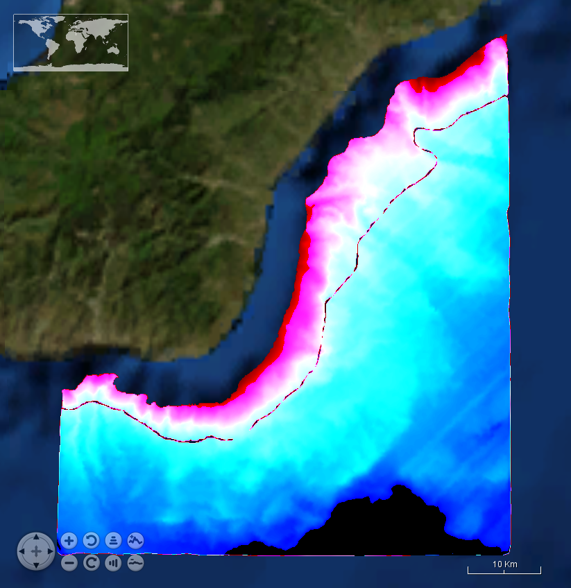
SOUTH%20CALABRIA.png
Spatial extent
N
S
E
W
Provided by

Associated resources
Not available