 Catalogue PIGMA
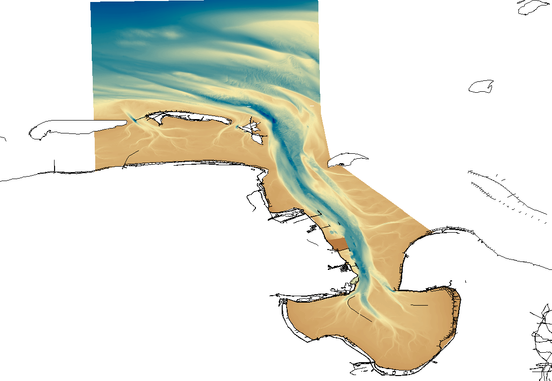
1850 HRDTM 1/512 Jade approach
Simple
- Alternate title
- DGMW_JADE
- Date (Creation)
- 2013-01-30T00:00:00
- Date (Revision)
- 2013-01-30T00:00:00
- Identifier
- DGMW_JADE
- Project name
-
- EMODNet Bathymetry
- SeaDataNet device categories
-
- single-beam echosounders
- multi-beam echosounders
- SeaDataNet device categories
-
- Differential Global Positioning System receivers
- Parameter Discovery Vocabulary (P02)
-
- Bathymetry and Elevation
- GEMET - INSPIRE themes, version 1.0
-
- Hydrography
- Access constraints
- Creative Commons Attribution 4.0 International
- Use constraints
- Other restrictions
- Other constraints
- DO NOT USE FOR NAVIGATION
- Spatial representation type
- Grid
- Denominator
- 5000
- Distance
- 0.0019531 Arc minute
- Metadata language
- English
- Character set
- UTF8
- Topic category
-
- Oceans
- Begin date
- 2009-03-18
- End date
- 2012-07-31
))
- Geographic identifier
- North Sea
- Description
-
Map projection parameters, values and units :
Axes units :
- Geographic identifier
- EPSG / UTM-32 / 7.4
- Reference system identifier
- EPSG / WGS84 (EPSG:4326) / 7.4
- Number of dimensions
- 3
- Dimension name
- Column
- Dimension size
- 12288
- Dimension name
- Row
- Dimension size
- 23040
- Dimension name
- Time
- Dimension size
- 1
- Cell geometry
- Point
- Transformation parameter availability
- No
- Checkpoint Availability
- No
- Point in Pixel
-
- Center
- Distribution format
-
-
ESRI Grid, ASCII Grid
(
)
-
ESRI Grid, ASCII Grid
(
)
- Transfer size
- 600
- OnLine resource
- http://www.bsh.de ( WWW:LINK )
- OnLine resource
- EMODnet viewer ( WWW:LINK )
- OnLine resource
- EMODnet Bathymetry WMTS service ( WWW:LINK )
- OnLine resource
-
jade_v2_1 - Format EMO
(
WWW:DOWNLOAD
)
jade_v2_1 - Format EMO
- OnLine resource
-
jade_v2_2 - Format EMO
(
WWW:DOWNLOAD
)
jade_v2_2 - Format EMO
- OnLine resource
-
jade_v2_3 - Format EMO
(
WWW:DOWNLOAD
)
jade_v2_3 - Format EMO
- OnLine resource
-
jade_v2_4 - Format EMO
(
WWW:DOWNLOAD
)
jade_v2_4 - Format EMO
- OnLine resource
-
jade_v2_5 - Format EMO
(
WWW:DOWNLOAD
)
jade_v2_5 - Format EMO
- OnLine resource
-
jade_v2_6 - Format EMO
(
WWW:DOWNLOAD
)
jade_v2_6 - Format EMO
- OnLine resource
-
jade_v2_7 - Format EMO
(
WWW:DOWNLOAD
)
jade_v2_7 - Format EMO
- OnLine resource
-
jade_v2_8 - Format EMO
(
WWW:DOWNLOAD
)
jade_v2_8 - Format EMO
- OnLine resource
-
jade_v2_9 - Format EMO
(
WWW:DOWNLOAD
)
jade_v2_9 - Format EMO
- Hierarchy level
- Dataset
Vertical extent
- Minimum value
- 0
- Maximum value
- 40.2
Vertical CS
Vertical datum
- Statement
- no information
- Hierarchy level
- Feature
- Dataset
- accuracy
Gridded data positional accuracy
- Name of measure
- horizontal accuracy
- Measure identification
- horizontal accuracy of coordinate
Quantitative result
- Value type
- horizontal accuracy
Quantitative attribute accuracy
- Name of measure
- depth
- Measure identification
- depth accuracy
Quantitative result
- Value
- not defined
Conformance result
- Date
- Hierarchy level
- Software
- Other
- software
- Hierarchy level
- Property type
- Description
- parameters of data processing
- Statement
- Description of data processing :
- Description
- CDIs: 96_32121_12, 96_32122_12, 963412_12, 962611_11, 96_33123_12, 96_33121_12, 96_33122_12, 96_32123_12, 96_32124_12, 96_3211_11, 96_JWED_16_10, 96_JWED_14_09, 96_JWED_17_09
- Hierarchy level
- Dataset
Absolute external positional accuracy
- Name of measure
- emodnet-bathymetry.QI.Horizontal
- Value
- 3 - < 20 m
Absolute external positional accuracy
- Name of measure
- emodnet-bathymetry.QI.Vertical
- Value
- 3 - Lidar, SBES high frequency
Domain consistency
- Name of measure
- emodnet-bathymetry.QI.Purpose
- Value
- 3 - Hydrographic survey or compatible with hydrographic standards
- File identifier
- SDN_CPRD_1850_DGMW_JADE XML
- Metadata language
- English
- Character set
- UTF8
- Hierarchy level name
- Composite Product Record
- Date stamp
- 2025-03-07T14:08:28.152791Z
- Metadata standard name
- ISO 19115:2003/19139 - EMODNET - BATHYMETRY
- Metadata standard version
- 1.0
Overviews
Spatial extent
Provided by
