 Catalogue PIGMA
1850 HRDTM Weser approach - Version 2
Simple
- Date (Creation)
- Date (Revision)
- Identifier
- DGMW_Weser_V2
+49 40 3190-5000
http://www.bsh.de
+49 40 3190-5000
http://www.bsh.de
- Parameter Discovery Vocabulary (P02)
-
- Bathymetry and Elevation
- SeaDataNet device categories
-
- multi-beam echosounders
- Positioning devices
-
- Differential Global Positioning System receivers
- Vertical Datum
-
- Lowest Astronomical Tide
- Project name
-
- EMODnet HRSM
- Thèmes Sextant
-
- /Physical Environment/Bathymetry/Digital Terrain Model
- Access constraints
- Creative Commons Attribution 4.0 International
- Use constraints
- Other restrictions
- Other constraints
- DO NOT USE FOR NAVIGATION
- Denominator
- 5000
- Distance
- 0.00195313 Arc minute
- Metadata language
- English
- Character set
- UTF8
- Topic category
-
- Oceans
- Begin date
- 2010-04-27
- End date
- 2017-05-16
Vertical extent
- Minimum value
- 0
- Maximum value
- 28.2
))
- Number of dimensions
- 3
- Dimension name
- Column
- Dimension size
- 15015
- Dimension name
- Row
- Dimension size
- 16558
- Dimension name
- Time
- Dimension size
- 1
- Cell geometry
- Point
- Transformation parameter availability
- No
- Checkpoint Availability
- No
- Point in Pixel
-
- Center
- Distribution format
-
-
(
)
-
(
)
- Transfer size
- 700
- OnLine resource
- EMODnet viewer ( WWW:LINK )
- OnLine resource
- EMODnet Bathymetry WMTS service ( WWW:LINK )
- OnLine resource
-
weser_a1 - Format EMO
(
WWW:DOWNLOAD
)
weser_a1 - Format EMO
- OnLine resource
-
weser_a2 - Format EMO
(
WWW:DOWNLOAD
)
weser_a2 - Format EMO
- OnLine resource
-
weser_b1 - Format EMO
(
WWW:DOWNLOAD
)
weser_b1 - Format EMO
- OnLine resource
-
weser_b2 - Format EMO
(
WWW:DOWNLOAD
)
weser_b2 - Format EMO
- OnLine resource
-
weser_c1 - Format EMO
(
WWW:DOWNLOAD
)
weser_c1 - Format EMO
- OnLine resource
-
weser_c2 - Format EMO
(
WWW:DOWNLOAD
)
weser_c2 - Format EMO
- OnLine resource
-
weser_c3 - Format EMO
(
WWW:DOWNLOAD
)
weser_c3 - Format EMO
- Hierarchy level
- Dataset
Conformance result
- Date
- Pass
- No
Quantitative attribute accuracy
- Name of measure
- depth
- Measure identification
- depth accuracy
Quantitative result
- Value
- not defined
Gridded data positional accuracy
- Name of measure
- horizontal accuracy
- Measure identification
- horizontal accuracy of coordinate
Quantitative result
- Value type
- horizontal accuracy
Absolute external positional accuracy
- Name of measure
- emodnet-bathymetry.QI.Horizontal
- Value
- 3 - < 20 m
Absolute external positional accuracy
- Name of measure
- emodnet-bathymetry.QI.Vertical
- Value
- 3 - Lidar, SBES high frequency
Domain consistency
- Name of measure
- emodnet-bathymetry.QI.Purpose
- Value
- 3 - Hydrographic survey or compatible with hydrographic standards
- Hierarchy level
- Software
- Other
- software
- Hierarchy level
- Property type
- Description
- parameters of data processing
- Description
- CDIs: 96_9301610, 96_25111_11, 96_9301720, 96_281610, 96_9281602, 96_9281620, 96_9281710, 96_32121_12, 96_21166_10, 96_2613, 96_9261411, 96_20151_10, 96_9261412, 96_20141_10, 96_20142_10, 96_21143_10, 96_21167_10, 96_20164_10, 96_9241601, 96_9241602
- File identifier
- SDN_CPRD_1850_DGMW_Weser_V2 XML
- Metadata language
- English
- Character set
- UTF8
- Hierarchy level name
- Composite Product Record
- Date stamp
- 2022-10-06T15:32:12.327Z
- Metadata standard name
- ISO 19115:2003/19139 - EMODNET - BATHYMETRY
- Metadata standard version
- 1.0
+49 40 3190-5000
http://www.bsh.de
Overviews
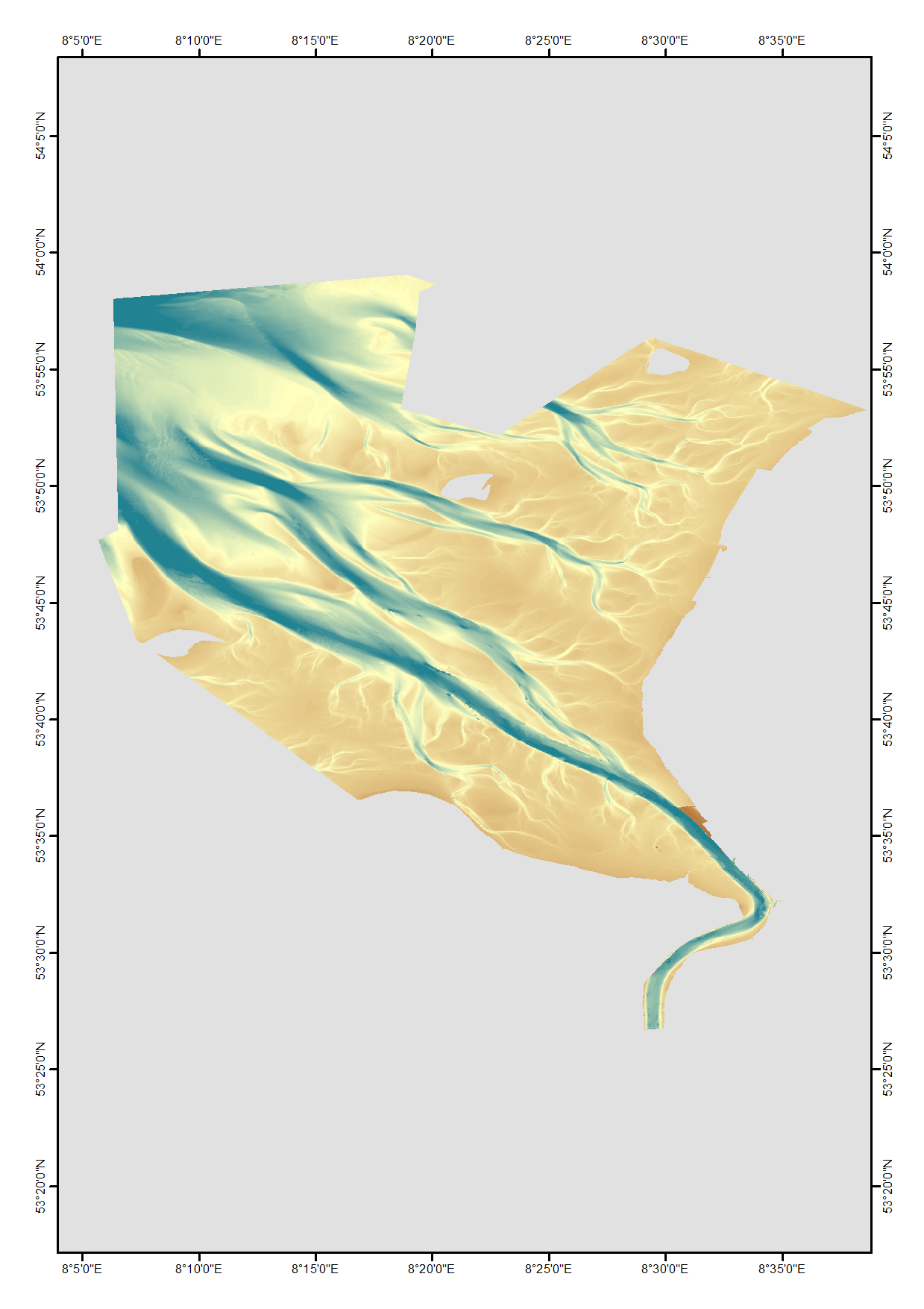
Spatial extent
Provided by
