 Catalogue PIGMA
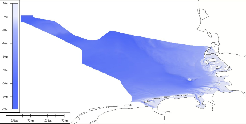
1850_EMODNET REGIONAL DTM OF GERMAN CONTINENTAL SHELF
DTM data source was received from the data center (Bathymetrisches Datenzentrum) of the German Hydrographic Office (Bundesamt für Seeschifffahrt und Hydrographie) at a variable resolution. The data was then processed by ATLIS b.v. using the ATLIS SENS software suite and compiled into an EMODnet regional DTM. Although the resolution varied throughout the dataset, no interpolation was required to create a geographic grid of 0.0041667 degrees resolution.
Simple
- Alternate title
- GERMANY-DTM-1
- Date (Creation)
- 2010-03-10T17:56:00
- Date (Revision)
- 2010-01-04T16:18:00
- Identifier
- GERMANY-DTM-1
- Thèmes Sextant
-
- /Physical Environment/Bathymetry/Digital Terrain Model
- Project name
-
- EMODNet Hydrography
- SeaDataNet device categories
-
- single-beam echosounders
- multi-beam echosounders
- Parameter Discovery Vocabulary (P02)
-
- Bathymetry and Elevation
- GEMET - INSPIRE themes, version 1.0
-
- Hydrography
- Use limitation
- See www.bsh.de
- Access constraints
- License
- Use constraints
- Copyright
- Use limitation
- Please refer to www.bsh.de for the terms of use (Bathymetrisches Datenzentrum)
- Spatial representation type
- Grid
- Denominator
- 500000
- Distance
- 0.0041667 Degrees north (degree_north)
- Metadata language
- English
- Character set
- UTF8
- Topic category
-
- Oceans
- Begin date
- 1970-01-01T16:17:00
N
S
E
W
))
- Geographic identifier
- North Sea
- Reference system identifier
- EPSG / WGS 84 (EPSG:4326) / 7.4
- Number of dimensions
- 3
- Dimension name
- Column
- Dimension size
- 605
- Dimension name
- Row
- Dimension size
- 1420
- Dimension name
- Time
- Dimension size
- 1
- Cell geometry
- Point
- Transformation parameter availability
- No
- Checkpoint Availability
- No
- Point in Pixel
-
- Center
- Distribution format
-
-
xyz
(
1.0
)
-
xyz
(
1.0
)
- OnLine resource
- http://www.bsh.de ( WWW:LINK )
- Hierarchy level
- Dataset
Vertical extent
- Minimum value
- -10
- Maximum value
- 69.3
Vertical CS
Vertical datum
- Statement
- no information
- Hierarchy level
- Feature
- Dataset
- accuracy
Gridded data positional accuracy
- Name of measure
- horizontal accuracy
- Measure identification
- horizontal accuracy of coordinate
- Measure description
- IHO S-44
- Evaluation method description
- IHO S-44
Quantitative result
- Value type
- horizontal accuracy
- Value
- IHO S-44
Quantitative attribute accuracy
- Name of measure
- depth
- Measure identification
- depth accuracy
- Measure description
- IHO S-44
- Evaluation method description
- IHO S-44
Quantitative result
- Value
- not defined
Conformance result
- Date
- Pass
- Yes
- Hierarchy level
- Software
- Other
- software
- Hierarchy level
- Property type
- Description
- parameters of data processing
- Statement
- Description of data processing :
- Description
- Description of processed data sources :
Overviews
Spatial extent
N
S
E
W
Provided by

Associated resources
Not available