 Catalogue PIGMA
252_CNR-15-Licosa_HR
This dataset was collected during a survey within GEOSED Project by means of the MBES system Reson SeaBat8111 in the area named Punta Licosa in the Tyrrhenian Sea, Central Mediterranean. The dataset was acquired on the continental shelf in the depth range 10-150 meters.The Multibeam has 101 beams 1°x1° and an operational frequency of 100 kHz. A LandStar 12 channel DGPS system was used for ship positioning and a motion sensor TSS-DMS02-05 was used to provide corrections for attitude data. A Sound Velocity Sensor was installed near the transducers thus providing realtime sound speed for beam steering. A sound velocity profiler Reson SVP20 was lowered through the water column every 6–8 h to get the velocity profile required for the depth computation. The bathymetric data were processed using the PDS2000 software. Data de-spiking was carried out without the application of automatic filters in order to preserve data accuracy and resolution
Simple
- Alternate title
- EMODNET-IFR-WESTMED-2012
- Date (Creation)
- 2018-10
- Date (Revision)
- 2018-10
- Identifier
- CNR-15-Licosa_HR
Custodian
CNR, Institute for the Marine and Coastal Environment (IAMC) - Napoli
+39 081 5423888
http://www.geomare.na.cnr.it
Calata Porta di Massa
,
Napoli
,
80133
,
Italy
+39 081 5423811
+39 081 5423888
http://www.geomare.na.cnr.it
- Project name
-
- EMODnet HRSM
- SeaDataNet device categories
-
- multi-beam echosounders
- Parameter Discovery Vocabulary (P02)
-
- Bathymetry and Elevation
- GEMET - INSPIRE themes, version 1.0
-
- Hydrography
- Access constraints
- Creative Commons Attribution 4.0 International
- Use constraints
- Other restrictions
- Other constraints
- DO NOT USE FOR NAVIGATION
- Spatial representation type
- Grid
- Denominator
- 10000
- Distance
- 0.0078125 Arc minute
- Metadata language
- English
- Character set
- UTF8
- Topic category
-
- Oceans
- Begin date
- 2002
- End date
- 2002 After
N
S
E
W
))
- Description
-
Map projection parameters, values and units :
Axes units :
- Codespace
- EPSG
- Version
- 7.4
- Reference system identifier
- EPSG / WGS 84 (EPSG:4326) / 7.4
- Number of dimensions
- 3
- Dimension name
- Column
- Dimension size
- 1536
- Dimension name
- Row
- Dimension size
- 1280
- Dimension name
- Time
- Dimension size
- 1
- Cell geometry
- Point
- Transformation parameter availability
- No
- Checkpoint Availability
- No
- Point in Pixel
-
- Upper left
- Distribution format
-
-
NetCDF
(
)
-
NetCDF
(
)
- Transfer size
- 40
- Protocol
- WWW:LINK
- Function
- Information
- OnLine resource
- EMODnet viewer ( WWW:LINK )
- OnLine resource
-
CNR-15-Licosa_HR - Format EMO
(
WWW:DOWNLOAD
)
CNR-15-Licosa_HR - Format EMO
- OnLine resource
- EMODnet Bathymetry WMTS service ( WWW:LINK )
- Hierarchy level
- Dataset
Vertical extent
- Minimum value
- 12.28
- Maximum value
- 143.74
Vertical CS
Vertical datum
- Statement
- no information
- Hierarchy level
- Feature
- Dataset
- accuracy
Gridded data positional accuracy
- Name of measure
- horizontal accuracy
- Measure identification
- horizontal accuracy of coordinate
- Measure description
- Between 50 cm and 1 m
- Evaluation method description
- Rough estimate from technical specification of used systems (Echosounder, GPS, motion sensor)
Quantitative result
- Value type
- horizontal accuracy
Quantitative attribute accuracy
- Name of measure
- depth
- Measure identification
- depth accuracy
- Measure description
- Between 0.5 cm and 20 cm
- Evaluation method description
- Rough estimate from technical specification of used systems (Echosounder, GPS, motion sensor)
Quantitative result
- Value
- not defined
Conformance result
- Date
- Hierarchy level
- Software
- Other
- software
- Hierarchy level
- Property type
- Description
- parameters of data processing
- Attributes
- Statement
- EMODnet processing methodology using Globe software
- Description
- CDI survey using multibeam echosounder used to produce the DTM is 252_CNR-IAMC-15
- Hierarchy level
- Dataset
Absolute external positional accuracy
- Name of measure
- emodnet-bathymetry.QI.Horizontal
- Value
- 3 - < 20 m
Absolute external positional accuracy
- Name of measure
- emodnet-bathymetry.QI.Vertical
- Value
- 2 - MBES low frequency (lower than 100kHz) (similar than 1+2%d)
Domain consistency
- Name of measure
- emodnet-bathymetry.QI.Purpose
- Value
- 2 - Bathymetric/morphologic survey
- File identifier
- SDN_CPRD_252_CNR-15-Licosa_HR XML
- Metadata language
- English
- Character set
- UTF8
- Hierarchy level name
- Product record
- Date stamp
- 2022-07-18T12:03:07.009Z
- Metadata standard name
- ISO 19115:2003/19139 - EMODNET - BATHYMETRY
- Metadata standard version
- 1.0
Author
CNR, Institute for the Marine and Coastal Environment (IAMC) - Napoli
+39 081 5423888
http://www.geomare.na.cnr.it
Calata Porta di Massa
,
Napoli
,
80133
,
Italy
+39 081 5423811
+39 081 5423888
http://www.geomare.na.cnr.it
Overviews
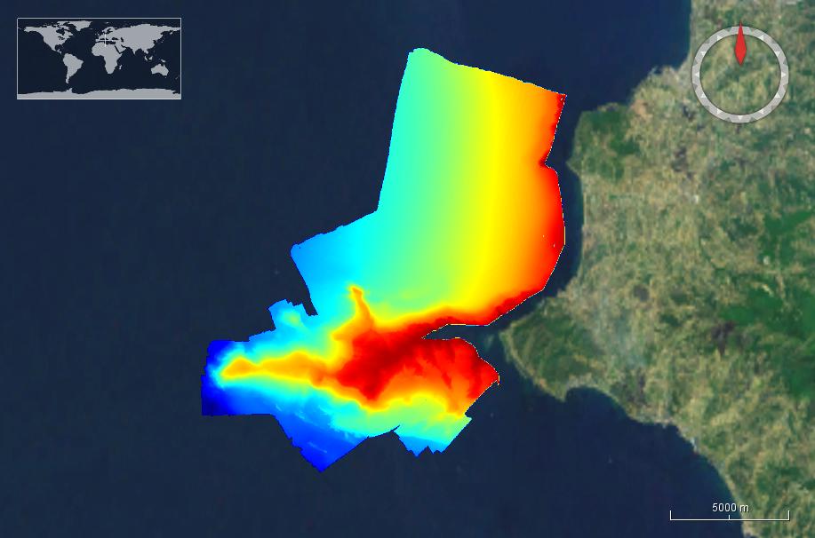
Image_Licosa_HR.jpg
Spatial extent
N
S
E
W
Provided by

Associated resources
Not available