 Catalogue PIGMA
2979_EMEPC_LH1_250_West_Central_Continental_Shelf_Portugal
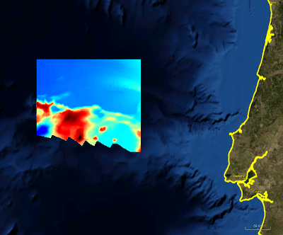
DTM derived from a hydrographic survey (EMEPC LH1) performed within the scope of the Portuguese Continental Shelf Extension Project (UNCLOS). The data made available to the Emodnet project was sampled from the survey data with an aproximate 250m sampling interval, in N-S and E-W directions.
Simple
- Alternate title
- EMEPC_LH1_250
- Date (Creation)
- 2014-06-26T15:30:00
- Date (Revision)
- 2014-06-26T15:30:00
- Identifier
- EMEPC_LH1_250
- Project name
-
- EMODNet Hydrography
- Parameter Discovery Vocabulary (P02)
-
- Bathymetry and Elevation
- GEMET - INSPIRE themes, version 1.0
-
- Hydrography
- Access constraints
- Restricted
- Use constraints
- Restricted
- Use limitation
- Not for navigation.
- Spatial representation type
- Grid
- Denominator
- 200000
- Distance
- 250 Metres (m)
- Metadata language
- English
- Character set
- UTF8
- Topic category
-
- Oceans
- Begin date
- 2005-02-10T00:00:00
- End date
- 2005-04-14T00:00:00
N
S
E
W
))
- Geographic identifier
- Atlantic Ocean
- Description
-
Map projection parameters, values and units :
Axes units :
- Geographic identifier
- EPSG / WGS 84 / 7.4
- Reference system identifier
- EPSG / WGS 84 (EPSG:4326) / 7.4
- Number of dimensions
- 3
- Dimension name
- Column
- Dimension size
- 936
- Dimension name
- Row
- Dimension size
- 640
- Dimension name
- Time
- Dimension size
- 1
- Resolution
- hour
- Cell geometry
- Point
- Transformation parameter availability
- No
- Checkpoint Availability
- No
- Point in Pixel
-
- Center
- Distribution format
-
-
Text
(
1.0
)
-
Text
(
1.0
)
- Transfer size
- 10
- OnLine resource
-
Contact filipe.brandao@emepc.mam.gov.pt
(
WWW:LINK
)
Contact filipe.brandao@emepc.mam.gov.pt
- Hierarchy level
- Dataset
Vertical extent
- Minimum value
- 2416
- Maximum value
- 5540
Vertical CS
Vertical datum
- Statement
- no information
- Hierarchy level
- Feature
- Dataset
- accuracy
Gridded data positional accuracy
- Name of measure
- horizontal accuracy
- Measure identification
- horizontal accuracy of coordinate
- Evaluation method description
- Size of grid and data samping interval
Quantitative attribute accuracy
- Name of measure
- depth
- Measure identification
- depth accuracy
Quantitative result
- Value
- not defined
Conformance result
- Date
- Pass
- No
- Hierarchy level
- Software
- Description
- Caris Hips and Sips
- Other
- software
- Hierarchy level
- Property type
- Description
- parameters of data processing
- Statement
-
Description of data processing :
CARIS HIPS Data processing and Validation Procedures.
Sound Velocity Profiles were made whenever the sound velocity presented significant variations.
- Hierarchy level
- Dataset
Absolute external positional accuracy
- Name of measure
- emodnet-bathymetry.QI.Horizontal
- Value
- 3 - < 20 m
Absolute external positional accuracy
- Name of measure
- emodnet-bathymetry.QI.Vertical
- Value
- 2 - MBES low frequency (lower than 100kHz) (similar than 1+2%d)
Domain consistency
- Name of measure
- emodnet-bathymetry.QI.Purpose
- Value
- 3 - Hydrographic survey or compatible with hydrographic standards
- File identifier
- SDN_CPRD_2979_EMEPC_LH1_250 XML
- Metadata language
- English
- Character set
- UTF8
- Hierarchy level name
- Composite Product Record
- Date stamp
- 2018-01-29T16:50:25
- Metadata standard name
- ISO 19115:2003/19139 - EMODNET - BATHYMETRY
- Metadata standard version
- 1.0
Overviews
Spatial extent
N
S
E
W
Provided by

Associated resources
Not available