 Catalogue PIGMA
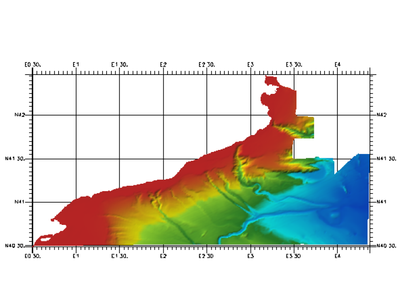
353_291002-Catalan Margin
Simple
- Alternate title
- 291002
- Date (Creation)
- 2010-04-28T00:00:00
- Date (Revision)
- 2010-04-28T18:00:00
- Identifier
- 291002
- Thèmes Sextant
-
- /Physical Environment/Bathymetry/Digital Terrain Model
- Project name
-
- EMODNet Hydrography
- SeaDataNet device categories
-
- multi-beam echosounders
- SeaDataNet device categories
-
- Differential Global Positioning System receivers
- Parameter Discovery Vocabulary (P02)
-
- Bathymetry and Elevation
- GEMET - INSPIRE themes, version 1.0
-
- Hydrography
- Access constraints
- Restricted
- Use constraints
- Copyright
- Other constraints
- Contact ideo@ieo.es
- Use limitation
- Not for navigation
- Spatial representation type
- Grid
- Denominator
- 200000
- Distance
- 0.0027 Degrees north (degree_north)
- Metadata language
- English
- Character set
- UTF8
- Topic category
-
- Oceans
- Begin date
- 1994-04-01T12:00:00
- End date
- 2004-11-01T12:00:00
))
- Geographic identifier
- Balearic (Iberian) Sea (Mediterranean Sea)
- Reference system identifier
- EPSG / WGS 84 (EPSG:4326) / 7.4
- Number of dimensions
- 3
- Dimension name
- Column
- Dimension name
- Row
- Dimension name
- Time
- Dimension size
- 1
- Cell geometry
- Point
- Transformation parameter availability
- No
- Checkpoint Availability
- No
- Point in Pixel
-
- Center
- Distribution format
-
-
ESRI GRD
(
not specified
)
-
ESRI GRD
(
not specified
)
- OnLine resource
-
Web site of the Istituto Espanol de Oceanografia (IEO)
(
WWW:LINK
)
Contact ideo@ieo.es
- Hierarchy level
- Dataset
Vertical extent
- Minimum value
- 0
- Maximum value
- 2890
Vertical CS
Vertical datum
- Statement
- no information
- Hierarchy level
- Feature
- Dataset
- accuracy
Gridded data positional accuracy
- Name of measure
- horizontal accuracy
- Measure identification
- horizontal accuracy of coordinate
- Measure description
- Not specified
- Evaluation method description
- In all case, multiple tests have been made in order to use the method which would introduce less error in the result.
Quantitative result
- Value type
- horizontal accuracy
Quantitative attribute accuracy
- Name of measure
- depth
- Measure identification
- depth accuracy
- Measure description
- Not specified
- Evaluation method description
- In all case, multiple tests have been made in order to use the method which would introduce less error in the result.
Quantitative result
- Value
- not defined
Conformance result
- Date
- Pass
- No
- Hierarchy level
- Software
- Description
- ArcGIS/IDW
- Other
- software
- Hierarchy level
- Property type
- Description
- parameters of data processing
- Statement
-
Description of data processing :
Source data received from data owners were DTM in GRID format (raster format ArcGis, structured in a matrix regular bathymetry associated with the centre of the cell of two types of format (raster format of ArcGis) with different resolutions. From each grid, we obtained a point SHAPE file, each point corresponds to the centre of the cell on the grid. Each point has the depth value of each cell. With each point SHAPE file, we use de command IDW (ArcGis) to realize an IDW Interpolation, (assigning weight in function of inverse of the distance). We have worked with the number of points that produced less error, in each case.Finally a single DTM for this zone was created with the MOSAIC command of ArcGis, in this case never these grids are intersecting between them; the grids are adjacent with a small zone of intersection to avoid the appearance of holes.
- Description
-
Description of processed data sources :
This DTM has been elaborated from two grids (ArcGis raster format), both treated with the IDW method
The first is a grid of 25 x 25 meters of resolution derived from a SIMRAD 1000 MBES survey with information about continental shelf and slope.
The depths are between 5 and 160 meters. The vertical datum is Sea Level. This information has been obtained in the ESPACE project. Spanish Institute of Oceanography.Positioning .
The second is a grid of 100 x 100 meters of resolution derived from a SIMRAD MBES survey with information for depths between 5 and 2800 meters. The Vertical datum "Sea Level". This information has been obtained for the University of Cataluña.
- Hierarchy level
- Dataset
Absolute external positional accuracy
- Name of measure
- emodnet-bathymetry.QI.Horizontal
- Value
- 1 - Between 500m and 50m
Absolute external positional accuracy
- Name of measure
- emodnet-bathymetry.QI.Vertical
- Value
- 1 - SBES low frequency, SDB (similar than 2+5%d)
Domain consistency
- Name of measure
- emodnet-bathymetry.QI.Purpose
- Value
- 2 - Bathymetric/morphologic survey
- File identifier
- SDN_CPRD_353_291002 XML
- Metadata language
- English
- Character set
- UTF8
- Hierarchy level name
- Composite Product Record
- Date stamp
- 2018-01-29T16:31:26
- Metadata standard name
- ISO 19115:2003/19139 - EMODNET - BATHYMETRY
- Metadata standard version
- 1.0
Overviews
Spatial extent
Provided by
