 Catalogue PIGMA
353_291003-Balear Islands South Margin
Simple
- Alternate title
- 291003
- Date (Creation)
- 2010-04-28T12:00:00
- Date (Revision)
- 2010-04-28T12:00:00
- Identifier
- 291003
- Thèmes Sextant
-
- /Physical Environment/Bathymetry/Digital Terrain Model
- Project name
-
- EMODNet Hydrography
- SeaDataNet device categories
-
- multi-beam echosounders
- SeaDataNet device categories
-
- Differential Global Positioning System receivers
- Parameter Discovery Vocabulary (P02)
-
- Bathymetry and Elevation
- GEMET - INSPIRE themes, version 1.0
-
- Hydrography
- Access constraints
- Restricted
- Use constraints
- Copyright
- Other constraints
- Contact ideo@ieo.es
- Use limitation
- Not for navigation
- Spatial representation type
- Grid
- Denominator
- 200000
- Distance
- 0.002 Degrees north (degree_north)
- Metadata language
- English
- Character set
- UTF8
- Topic category
-
- Oceans
- Begin date
- 2005-04-01T12:00:00
- End date
- 2005-10-01T12:00:00
))
- Geographic identifier
- Balearic (Iberian) Sea (Mediterranean Sea)
- Reference system identifier
- EPSG / WGS 84 (EPSG:4326) / 7.4
- Number of dimensions
- 3
- Dimension name
- Column
- Dimension name
- Row
- Dimension name
- Time
- Dimension size
- 1
- Cell geometry
- Point
- Transformation parameter availability
- No
- Checkpoint Availability
- No
- Point in Pixel
-
- Center
- Distribution format
-
-
ESRI GRD
(
not specified
)
-
ESRI GRD
(
not specified
)
- OnLine resource
-
Web site of the stituto Espanol de Oceanografia (IEO)
(
WWW:LINK
)
Contact ideo@ieo.es
- Hierarchy level
- Dataset
Vertical extent
- Minimum value
- 1144
- Maximum value
- 2841
Vertical CS
Vertical datum
- Statement
- no information
- Hierarchy level
- Feature
- Dataset
- accuracy
Gridded data positional accuracy
- Name of measure
- horizontal accuracy
- Measure identification
- horizontal accuracy of coordinate
- Measure description
- Not specified
- Evaluation method description
- In all case, multiple tests have been made in order to use the method which would introduce less error in the result
Quantitative result
- Value type
- horizontal accuracy
Quantitative attribute accuracy
- Name of measure
- depth
- Measure identification
- depth accuracy
- Measure description
- Not specified
- Evaluation method description
- In all case, multiple tests have been made in order to use the method which would introduce less error in the result.
Quantitative result
- Value
- not defined
Conformance result
- Date
- Pass
- No
- Hierarchy level
- Software
- Other
- software
- Hierarchy level
- Property type
- Description
- parameters of data processing
- Statement
-
Description of data processing :
Data were processed and filtered. A DTM was made by the data owner with 200x200 meters of resolution. This DTM was transformed to Geographic Coordinates with the PROJECT command of ArcGis software, with a resolution of 0,0020 decimal degrees.
- Description
-
Description of processed data sources :
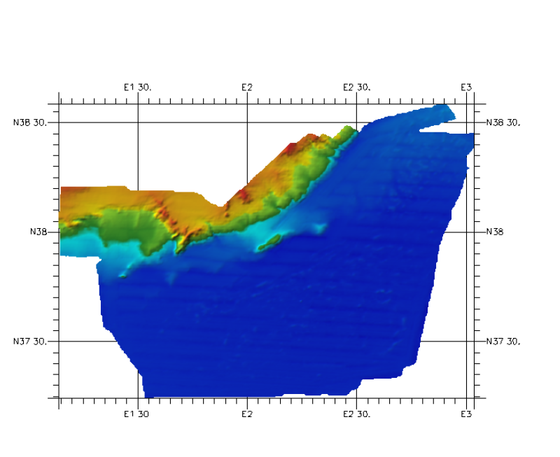
This DTM has been elaborated from one grid (ArcGis raster format), treated with the IDW method . The grid of 200 x 200 meters of resolution is derived from a RESON 8150 MBES survey made by OGS (R/V OGS EXPLORA ) with information about continental shelf and slope. The depths are between 1100 and 2800 meters. The vertical datum is Sea level.
- Hierarchy level
- Dataset
Absolute external positional accuracy
- Name of measure
- emodnet-bathymetry.QI.Horizontal
- Value
- -1 - Multisources
Absolute external positional accuracy
- Name of measure
- emodnet-bathymetry.QI.Vertical
- Value
- -1 - Multisources
Domain consistency
- Name of measure
- emodnet-bathymetry.QI.Purpose
- Value
- 2 - Bathymetric/morphologic survey
- File identifier
- SDN_CPRD_353_291003 XML
- Metadata language
- English
- Character set
- UTF8
- Hierarchy level name
- Composite Product Record
- Date stamp
- 2018-01-29T16:33:00
- Metadata standard name
- ISO 19115:2003/19139 - EMODNET - BATHYMETRY
- Metadata standard version
- 1.0
Overviews
Spatial extent
Provided by
