 Catalogue PIGMA
4036 HRDTM 1/64 Noto Canyon
The data were acquired with Reson SeaBat 7150 and 8111 multibeam echosounder systems on board the R/V OGS Explora in order to cover the Malta Escarpment for a geological survey in the framework of EU FP7 project SCARP.
Simple
- Date (Creation)
- Date (Revision)
- Identifier
- CUMECS2_Noto_Canyon
Originator
Marine Geology and Seafloor Surveying group, Department of Geosciences, University of Malta
115, Maths and Physics Building
,
Msida
,
MSD 2080
,
Malta
http://www.um.edu.mt/science/geosciences/mgss
Custodian
Marine Geology and Seafloor Surveying group, Department of Geosciences, University of Malta
115, Maths and Physics Building
,
Msida
,
MSD 2080
,
Malta
http://www.um.edu.mt/science/geosciences/mgss
- Parameter Discovery Vocabulary (P02)
-
- Bathymetry and Elevation
- SeaDataNet device categories
-
- multi-beam echosounders
- Positioning devices
-
- Differential Global Positioning System receivers
- Vertical Datum
-
- Lowest Astronomical Tide
- Project name
-
- EMODnet HRSM
- Thèmes Sextant
-
- /Physical Environment/Bathymetry/Digital Terrain Model
- Access constraints
- Creative Commons Attribution 4.0 International
- Use constraints
- Other restrictions
- Other constraints
- DO NOT USE FOR NAVIGATION
- Spatial representation type
- Grid
- Denominator
- 50000
- Distance
- 0.15625 Arc minute
- Metadata language
- English
- Character set
- UTF8
- Topic category
-
- Oceans
- Begin date
- 2014-08-31
- End date
- 2014-09-04
Vertical extent
- Minimum value
- 77
- Maximum value
- 2832
N
S
E
W
))
- Reference system identifier
- EPSG / WGS 84 (EPSG:4326) / 7.4
- Number of dimensions
- 3
- Dimension name
- Column
- Dimension size
- 1088
- Dimension name
- Row
- Dimension size
- 768
- Dimension name
- Time
- Dimension size
- 1
- Cell geometry
- Point
- Transformation parameter availability
- No
- Checkpoint Availability
- No
- Point in Pixel
-
- Distribution format
-
-
NetCDF
(
)
-
NetCDF
(
)
- Transfer size
- 11
- OnLine resource
- EMDOnet viewer ( WWW:LINK )
- OnLine resource
-
CUMECS2_Cumecs_Canyon - Format EMO
(
WWW:DOWNLOAD
)
CUMECS2_Cumecs_Canyon - Format EMO
- OnLine resource
- EMODnet Bathymetry WMTS service ( WWW:LINK )
- Hierarchy level
- Dataset
Conformance result
- Date
- Pass
- No
Quantitative attribute accuracy
- Name of measure
- depth
- Measure identification
- depth accuracy
Quantitative result
- Value
- not defined
Gridded data positional accuracy
- Name of measure
- horizontal accuracy
- Measure identification
- horizontal accuracy of coordinate
Quantitative result
- Value type
- horizontal accuracy
Absolute external positional accuracy
- Name of measure
- emodnet-bathymetry.QI.Horizontal
- Value
- 2 - Between 50 m and 20 m
Absolute external positional accuracy
- Name of measure
- emodnet-bathymetry.QI.Vertical
- Value
- 4 - MBES High frequency (higher that 100kHz) (1+0.5%d)
Domain consistency
- Name of measure
- emodnet-bathymetry.QI.Purpose
- Value
- 2 - Bathymetric/morphologic survey
- Hierarchy level
- Software
- Other
- software
- Hierarchy level
- Property type
- Description
- parameters of data processing
- Statement
- EMODnet processing methodology using Globe software
- Description
- 4036_CUMECS2
- File identifier
- SDN_CPRD_4036_CUMECS2_Noto_Canyon XML
- Metadata language
- English
- Character set
- UTF8
- Hierarchy level name
- Composite Product Record
- Date stamp
- 2022-07-18T12:21:43.29Z
- Metadata standard name
- ISO 19115:2003/19139 - EMODNET - BATHYMETRY
- Metadata standard version
- 1.0
Overviews
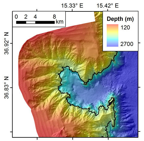
Noto Canyon
Spatial extent
N
S
E
W
Provided by

Associated resources
Not available