 Catalogue PIGMA
9496-25-DTM - Site Survey of Dogger Bank Tranche C Offshore Wind Farm Area by Gardline Geosurvey Ltd
Gardline Geosurvey Limited was contracted to survey the Dogger Bank Offshore Wind Farm (OWF) Area between 04-Apr-2013 and 02-Aug-2013, comprising the Tranche C zonal surveys. The aim of the surveys was to carry out a geophysical investigation that would broadly assess the entire developable area of the zone. Seabed information was required to inform the site selection process and enable preliminary foundation design to be undertaken. The geological data acquisition programme was carried out on M.V. Sea Surveyor, which sailed from Hull and returned to Blyth, and M.V. Vigilant which sailed from, and returned to, Great Yarmouth upon completion of survey operations. The Crown Estate is the data owner and copyright holder.
Simple
- Alternate title
- 43_9496-25-DTM
- Date (Creation)
- 2022-03-09
- Date (Revision)
- 2022-03-09
- Identifier
- 9496-25-DTM
- Project name
-
- EMODNet Bathymetry
- SeaDataNet device categories
-
- multi-beam echosounders
- Parameter Discovery Vocabulary (P02)
-
- Bathymetry and Elevation
- GEMET - INSPIRE themes, version 1.0
-
- Hydrography
- Access constraints
- Creative Commons Attribution 4.0 International
- Use constraints
- Creative Commons Attribution 4.0 International
- Use limitation
- Not for navigation
- Spatial representation type
- Grid
- Distance
- 3.75 Arc second
- Metadata language
- English
- Character set
- UTF8
- Topic category
-
- Oceans
- Begin date
- 2013-04-04
- End date
- 2013-08-02 Before
N
S
E
W
))
- Description
-
Map projection parameters, values and units :
Axes units :
- Codespace
- EPSG
- Version
- 7.4
- Reference system identifier
- EPSG / WGS 84 (EPSG:4326) / 7.4
- Reference system identifier
- WGS 84 / UTM zone 31N (EPSG:32631) /
- Number of dimensions
- 3
- Dimension name
- Column
- Dimension size
- 1168
- Dimension name
- Row
- Dimension size
- 320
- Dimension name
- Time
- Dimension size
- 1
- Cell geometry
- Point
- Transformation parameter availability
- No
- Checkpoint Availability
- No
- Point in Pixel
-
- Center
- Distribution format
-
-
ASCII XYZ
(
)
-
ASCII XYZ
(
)
- OnLine resource
-
Gardline Geosurvey's original survey datasets
(
WWW:LINK
)
The original datasets from the Dogger Bank Tranche C OWF survey area acquired by Gardline Geosurvey Ltd
- Hierarchy level
- Dataset
Vertical extent
- Minimum value
- 28.37
- Maximum value
- 45.12
Vertical CS
Vertical datum
- Statement
- no information
- Hierarchy level
- Feature
- Dataset
- accuracy
Gridded data positional accuracy
- Name of measure
- horizontal accuracy
- Measure identification
- horizontal accuracy of coordinate
Quantitative result
- Value type
- horizontal accuracy
Quantitative attribute accuracy
- Name of measure
- depth
- Measure identification
- depth accuracy
Quantitative result
- Value
- not defined
Conformance result
- Date
- Hierarchy level
- Software
- Other
- software
- Hierarchy level
- Property type
- Description
- parameters of data processing
- Attributes
- Statement
- Data were processed by Gardline Geosurvey Limited using Caris HIPS and SIPS software (v7.1). A 25m resolution DTM file was produced and made available to the British Oceanographic Data Centre (BODC). The 25m DTM file was then converted by BODC using Globe software (v1.18.18) to the EMODnet Bathymetry standard DTM.NC format at 3.75 arc seconds resolution.
- Description
- The bathymetric survey data from both vessels were acquired using Kongsberg Simrad EM710 multibeam echo-sounders, one per vessel. A transducer frequency range of 70-100 kHz was used on the M.V. Sea Surveyor, whereas a 95 kHz transducer frequency was used on the M.V. Vigilant. The EM710 achieved an angular coverage of 68deg/68deg with 400 beams on both vessels.
- Hierarchy level
- Dataset
Absolute external positional accuracy
- Name of measure
- emodnet-bathymetry.QI.Horizontal
- Value
- 3 - < 20 m
Absolute external positional accuracy
- Name of measure
- emodnet-bathymetry.QI.Vertical
- Value
- 2 - MBES low frequency (lower than 100kHz) (similar than 1+2%d)
Domain consistency
- Name of measure
- emodnet-bathymetry.QI.Purpose
- Value
- 2 - Bathymetric/morphologic survey
- File identifier
- SDN_CPRD_43_9496-25-DTM XML
- Metadata language
- English
- Character set
- UTF8
- Hierarchy level name
- Product record
- Date stamp
- 2022-04-05T08:41:11.675Z
- Metadata standard name
- ISO 19115:2003/19139 - EMODNET - BATHYMETRY
- Metadata standard version
- 1.0
Overviews
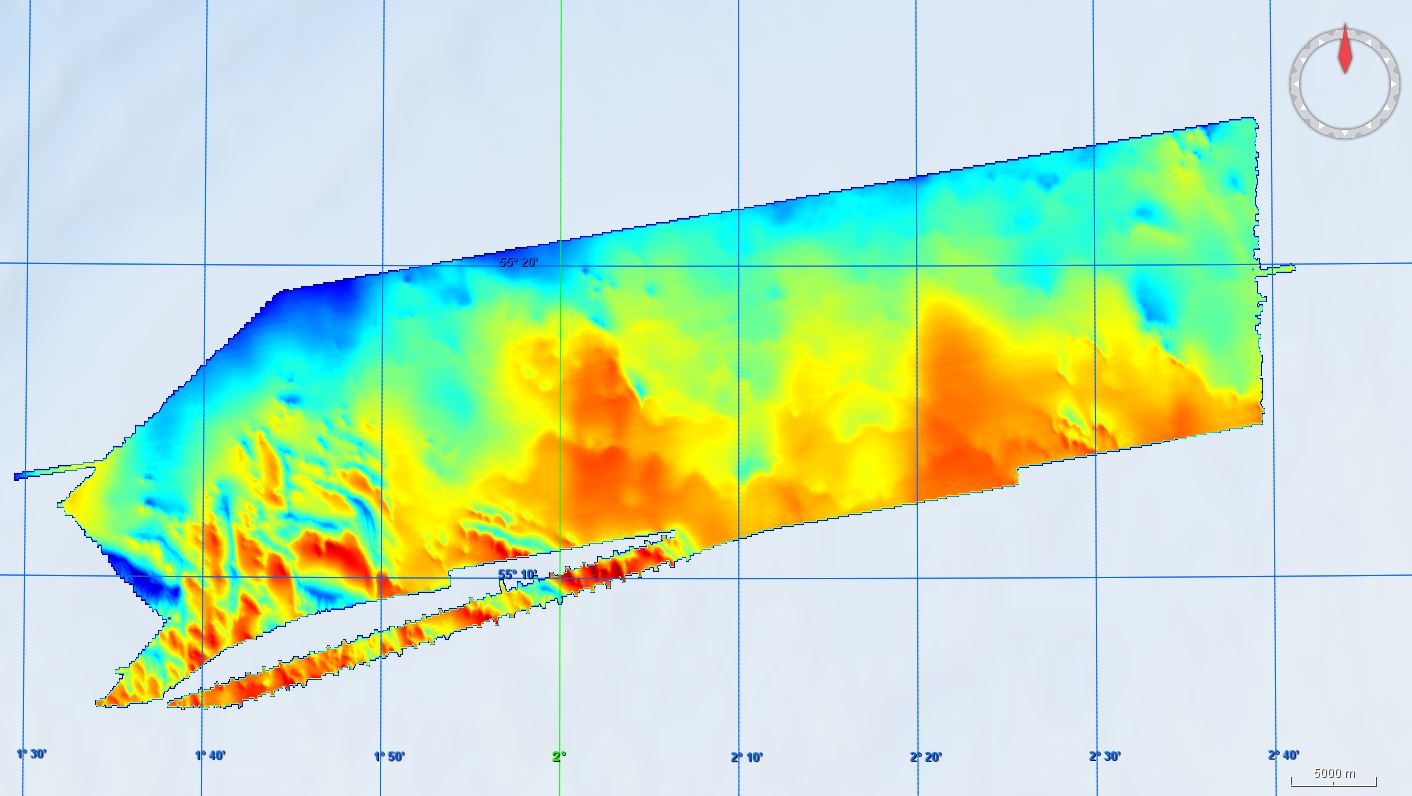
43_9496-25-DTM.JPG
Spatial extent
N
S
E
W
Provided by

Associated resources
Not available