 Catalogue PIGMA
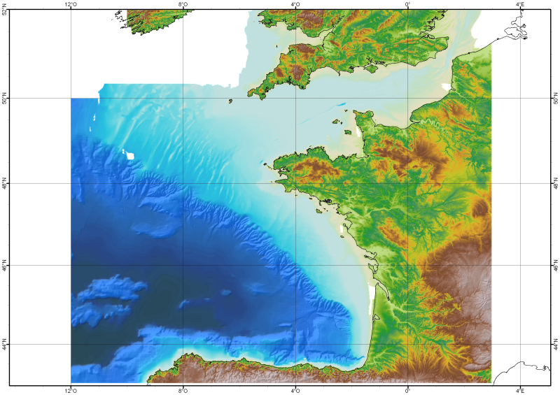
486_Bathymetry_Bay of Biscay - Channel (DTM resolution : 1000m ; ed. : 2008)
Simple
- Alternate title
- IFR_MBAN_MANCHEGASC_1000_01_R
- Date (Creation)
- 2008-06-30T12:58:00
- Date (Revision)
- Identifier
- IFR_MBAN_MANCHEGASC_1000_01_R
IFREMER Centre de Bretagne
ZI Pointe du diable
CS 10070
, PLOUZANE , 29280 , France+33(0)2 98.22.45.70
http://www.ifremer.fr/drogm/
IFREMER Centre de Bretagne
ZI Pointe du diable
CS 10070
, PLOUZANE , 29280 , France+33 (0)2 98.22.46.44
http://www.ifremer.fr/sismer/
- Thèmes Sextant
-
- /Physical Environment/Bathymetry/Digital Terrain Model
- Project name
-
- EMODNet Seabed Mapping
- SeaDataNet device categories
-
- single-beam echosounders
- multi-beam echosounders
- Parameter Discovery Vocabulary (P02)
-
- Bathymetry and Elevation
- GEMET - INSPIRE themes, version 1.0
-
- Hydrography
- Access constraints
- Restricted
- Use constraints
- Copyright
- Other constraints
-
(c) Ifremer - SHOM 2010
Obligation of citation :
Loubrieu B., Bourillet J.F., Moussat E.Bathy-morphologie régionale du Golfe de Gascogne et de la Manche, modèle numérique 2008 - Rapport interne Ifremer DCD/GM/CTDI/08-01.
(c) SHOM 2006 Works carried out using data transmitted by Service Hydrographique et Océanographique de la Marine (contract E97-2006) - www.shom.fr - SHOM is not responsible of the results and of the use of the results. All rights reserved except for Research and Education.
- Use limitation
- Not for navigation.
- Spatial representation type
- Grid
- Denominator
- 1000000
- Distance
- 1000 Metres (m)
- Metadata language
- English
- Character set
- UTF8
- Topic category
-
- Oceans
- Begin date
- 1900-01-01T00:00:00
- End date
- 2007-12-31T00:00:00
))
- Geographic identifier
- Bay of Biscay
- Description
-
Standard parallel N46
Axes units : meters
- Geographic identifier
- EPSG / Mercator / 7.4
- Reference system identifier
- EPSG / WGS 84 (EPSG:4326) / 7.4
- Number of dimensions
- 3
- Dimension name
- Column
- Dimension size
- 1033
- Dimension name
- Row
- Dimension size
- 1162
- Dimension name
- Time
- Dimension size
- 1
- Cell geometry
- Point
- Transformation parameter availability
- No
- Checkpoint Availability
- No
- Point in Pixel
-
- Center
- Distribution format
-
-
NetCDF
(
3
)
- Specification
- Ifremer format of Caraibes for grid
-
NetCDF
(
3
)
IFREMER Centre de Bretagne
ZI Pointe du diable
CS 10070
, PLOUZANE , 29280 , France+33 (0)2 98.22.46.44
http://www.ifremer.fr/sismer/
- Transfer size
- 2.5
- Hierarchy level
- Dataset
Vertical extent
- Minimum value
- 0
- Maximum value
- 5174
Vertical CS
Vertical datum
- Statement
- no information
- Hierarchy level
- Feature
- Dataset
- accuracy
Gridded data positional accuracy
- Name of measure
- horizontal accuracy
- Measure identification
- horizontal accuracy of coordinate
- Measure description
- Depends on the source of data : of the order of 0.05 minute to 1 minute
- Evaluation method description
- Rough estimate from accuracies of maps and of positioning systems of the surveys
Quantitative result
- Value type
- horizontal accuracy
Quantitative attribute accuracy
- Name of measure
- depth
- Measure identification
- depth accuracy
- Measure description
- Usually better than the GEBCO version available at the time of the creation of the DTM
- Evaluation method description
- Visual comparison together with information on the source data
Quantitative result
- Value
- not defined
Conformance result
- Date
- Pass
- Yes
- Hierarchy level
- Software
- Description
- Isatis (Geovariances), GMT, Caraibes (Ifremer)
- Other
- software
- Hierarchy level
- Property type
- Description
- parameters of data processing
- Statement
- Description of data processing : Data processing has been carried out using krieging for data derived from contours, and simpler griding and merging algorithm for high data density (soundings and source DTMs).
- Description
-
Description of processed data sources :
Several sources have used among which : the multibeam echo sounder surveys from Ifremer (Seabeam, EM12D, EM 300) in the French EEZ in waters usually deeper than 200m), DTMs at 500m of resolution produced by SHOM using soundings of its bathymetric Data Base on the French continental shelf, digitized bathymetric maps pusbished by Berthois from 1974 to 1983 gridded at 500m of resolution, the SRMT 30 arc second topographic model.
- File identifier
- SDN_CPRD_486_IFR_MBAN_MANCHEGASC_1000_01_R XML
- Metadata language
- English
- Character set
- UTF8
- Hierarchy level name
- Composite Product Record
- Date stamp
- 2021-08-19T10:44:37
- Metadata standard name
- ISO 19115:2003/19139 - EMODNET - BATHYMETRY
- Metadata standard version
- 1.0
IFREMER Centre de Bretagne
ZI Pointe du diable
CS 10070
, PLOUZANE , 29280 , France+33 (0)2 98.22.46.44
http://www.ifremer.fr/sismer/
Overviews
Spatial extent
Provided by
