 Catalogue PIGMA
574_HY22111A_B
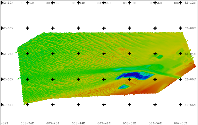
Approach Port of Rotterdam, Maas North and South side. There are sand waves, sand pits, dredged approach channel. Surveyed by one of the Hydrographic Survey Vessels of the Royal Netherlands Navy.
Simple
- Date (Creation)
- 2022-11-04
- Date (Revision)
- 2022-11-04
- Identifier
- HY22111A_B
Originator
Royal Netherlands Navy, Hydrographic Service
+31889516752
http://www.hydro.nl
Frederik Barracks,
Building 32,
Van Alkemadelaan 786
, The Hague , 2597 BC , Netherlandshttp://www.hydro.nl
Custodian
Royal Netherlands Navy, Hydrographic Service
+31889516752
http://www.hydro.nl
Frederik Barracks,
Building 32,
Van Alkemadelaan 786
, The Hague , 2597 BC , Netherlandshttp://www.hydro.nl
- Project name
-
- EMODNet Bathymetry
- SeaDataNet device categories
-
- multi-beam echosounders
- Parameter Discovery Vocabulary (P02)
-
- Bathymetry and Elevation
- GEMET - INSPIRE themes, version 1.0
-
- Hydrography
- SeaDataNet depth measurement reference planes
-
- Lowest Astronomical Tide
- Use limitation
- NOT FOR NAVIGATION
- Access constraints
- unrestricted
- Use constraints
- Creative Commons Attribution 4.0 International
- Other constraints
- EMODnet Bathymetry Consortium (2024), EMODnet Digital High Resolution DTM
- Use limitation
- not suitable for navigation
- Spatial representation type
- Grid
- Denominator
- 50000
- Distance
- 0.015625 Arc minute
- Metadata language
- English
- Character set
- UTF8
- Topic category
-
- Oceans
- Begin date
- 2022-04-08
- End date
- 2022-05-23 After
N
S
E
W
))
- Description
-
Map projection parameters, values and units :
Axes units :
- Codespace
- EPSG
- Version
- 7.4
- Reference system identifier
- EPSG / WGS 84 (EPSG:4326) / 7.4
- Number of dimensions
- 3
- Dimension name
- Column
- Dimension size
- 1809
- Dimension name
- Row
- Dimension size
- 738
- Dimension name
- Time
- Dimension size
- 1
- Resolution
- 1 years
- Cell geometry
- Point
- Transformation parameter availability
- No
- Checkpoint Availability
- No
- Point in Pixel
-
- Center
- Distribution format
-
-
XYZ Ascii
(
1
)
-
XYZ Ascii
(
1
)
Distributor
Royal Netherlands Navy, Hydrographic Service
+31889516752
http://www.hydro.nl
Frederik Barracks,
Building 32,
Van Alkemadelaan 786
, The Hague , 2597 BC , Netherlandshttp://www.hydro.nl
- Transfer size
- 20.5
- OnLine resource
- web site Hydrographic Service of the Royal Netherlands Navy ( WWW:LINK )
- OnLine resource
- EMODnet Bathymetry WMTS service ( WWW:LINK )
- OnLine resource
- EMODnet viewer ( WWW:LINK )
- OnLine resource
-
HY22111A_B
(
WWW:DOWNLOAD
)
HY22111A_B
- Hierarchy level
- Dataset
Vertical extent
- Minimum value
- 9.3
- Maximum value
- 50.9
Vertical CS
Vertical datum
- Statement
- no information
- Hierarchy level
- Feature
- Dataset
- accuracy
Gridded data positional accuracy
- Name of measure
- horizontal accuracy
- Measure identification
- horizontal accuracy of coordinate
- Measure description
- According to S-44 order 1A
Quantitative result
- Value type
- horizontal accuracy
Quantitative attribute accuracy
- Name of measure
- depth
- Measure identification
- depth accuracy
- Measure description
- According to S-44 order 1A
Quantitative result
- Value
- not defined
Conformance result
- Date
- Pass
- No
- Hierarchy level
- Software
- Other
- software
- Hierarchy level
- Property type
- Description
- parameters of data processing
- Attributes
- Description
- CDI-record id 3466116
- Hierarchy level
- Dataset
Absolute external positional accuracy
- Name of measure
- emodnet-bathymetry.QI.Horizontal
- Value
- 3 - < 20 m
Absolute external positional accuracy
- Name of measure
- emodnet-bathymetry.QI.Vertical
- Value
- 4 - MBES High frequency (higher that 100kHz) (1+0.5%d)
Domain consistency
- Name of measure
- emodnet-bathymetry.QI.Purpose
- Value
- 3 - Hydrographic survey or compatible with hydrographic standards
- File identifier
- SDN_CPRD_574_HY22111A_B XML
- Metadata language
- English
- Character set
- UTF8
- Hierarchy level name
- Product record
- Date stamp
- 2025-04-10T13:09:04.886506Z
- Metadata standard name
- ISO 19115:2003/19139 - EMODNET - BATHYMETRY
- Metadata standard version
- 1.0
Author
Royal Netherlands Navy, Hydrographic Service
+31889516752
http://www.hydro.nl
Frederik Barracks,
Building 32,
Van Alkemadelaan 786
, The Hague , 2597 BC , Netherlandshttp://www.hydro.nl
Overviews
Spatial extent
N
S
E
W
Provided by

Associated resources
Not available