 Catalogue PIGMA
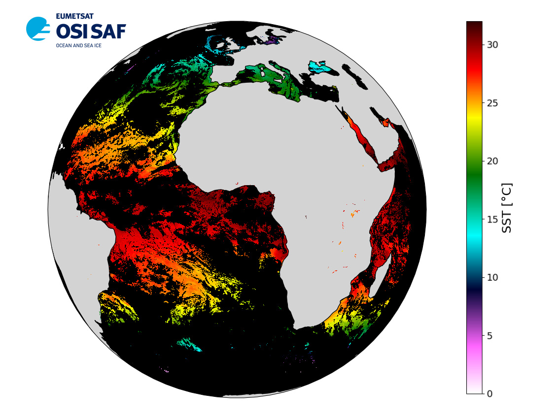
EUMETSAT OSI SAF MSG/SEVIRI Sea Surface Temperature data record
Data record (2004-2012) of level 3 hourly sub-skin Sea Surface Temperature derived from Meteosat at 0° longitude, covering 60S-60N and 60W-60E and re-projected on a 0.05° regular grid, in GHRSST compliant netCDF format.
The satellite input data come from the imager SEVIRI on MSG satellites (Meteosat-8 and Meteosat-9). SST is retrieved from SEVIRI infrared channels (10.8 and 12.0 µm) using a multispectral algorithm and the cloud mask from CM SAF. NWP outputs (temperature and humidity profiles), OSTIA Sea Surface Temperature re-analysis and analysis, together with a radiative transfer model (RTTOV), are used to correct the multispectral algorithm for regional and seasonal biases due to changing atmospheric conditions.
The product format is compliant with the GHRSST Data Specification (GDS) version 2. Users are advised to use data only with quality levels 3,4 and 5.
Simple
- Date (Creation)
- 2021-11-25T22:13:37.040Z
- Date (Revision)
- 2021-11-25T05:01:46.000Z
- Date (Publication)
- 2021-11-25
- Edition
- 1
- Edition date
- 2015-05-29T00:00:00.000Z
- Identifier
- gov.nasa.esdis.umm.shortname / SEVIRI_SST_DR-OSISAF-L3C-v1.0
- Codespace
- gov.nasa.esdis.umm.collectiondatatype
- Version
- SEVIRI_SST_DR-OSISAF-L3C-v1.0
- Name
- SEVIRI Atlantic SST
- Other citation details
- EUMETSAT/OSI SAF, EUMETSAT Ocean and Sea Ice Satellite Application Facility, Meteo-France/CMS, Lannion, France, 2015-05-29, GHRSST Level 3C Atlantic sub-skin Sea Surface Temperature from the Spinning Enhanced Visible and Infrared Imager (SEVIRI) on MSG at 0 degree longitude (GDS V2) produced by OSI SAF, www.osi-saf.org
- Status
- historicalArchive Historical archive
- Access constraints
- unrestricted
- Use constraints
- Copyright
- Other constraints
- Open Licence
- Other constraints
- EUMETSAT Ocean and Sea Ice Satellite Application Facility, MSG/SEVIRI Sea Surface Temperature data record 2001-2012 (v1.0, 2018), OSI-250, doi:10.15770/EUM_SAF_OSI_0004, data for [extracted period], [extracted domain], accessed [download date] from [distributor/distribution mean].
- Distance
- 0.05 degree
- Metadata language
- English
))
- Geographic identifier
- Global
- Begin date
- 2004-01-19
- End date
- 2012-12-31
- Reference system identifier
- CARTESIAN
- Reference system identifier
- http://www.opengis.net/def/crs/EPSG/0/4326
- Number of dimensions
- 2
Axis Dimensions Properties
Axis Dimensions Properties
- Distribution format
-
-
NetCDF
(
4
)
-
NetCDF
(
4
)
Distributor
- Name
- Format: Not provided MimeType: text/html
Distributor
- Name
- Format: Not provided MimeType: text/html
- OnLine resource
- Digital Object Identifier (DOI) ( DOI )
- OnLine resource
- OSI SAF Opensearch service ( WWW:LINK )
- OnLine resource
- PO.DAAC Cloud ( WWW:LINK )
- OnLine resource
- Ifremer HTTP server ( WWW:LINK )
- OnLine resource
-
User guide
(
WWW:LINK
)
Product User Manual
- OnLine resource
- EUMETCast ( WWW:BROADCAST )
- OnLine resource
-
Local path on Ifremer/Datarmor
(
NETWORK:LINK
)
Local path
- Hierarchy level
- Series
Accuracy of time measurement
- Measure identification
- PrecisionOfSeconds
Quantitative result
Content Information
- Attribute description
- Global gridded map
- Content type
- Physical measurement
- gmd:otherProperty
- earliest_granule_start_time Earliest Granule Start Time for dataset. 2004-06-01T00:00:00.000Z latest_granule_end_time Latest Granule Stop/End Time for dataset. 2021-05-21T13:26:57.000Z data_latency Dataset Latency 24 Series Name Dataset citation series name SEVIRI Atlantic SST Persistent ID Dataset Persistent ID PODAAC-GHSEV-3CO01
- Processing level code
- L3C /
Content Information
- File identifier
- b6e77fd4-fdf5-4848-b43f-9ccc01779b2c XML
- Metadata language
- English
- Character set
- UTF8
- Hierarchy level
- Series
- Date stamp
- 2025-11-01T16:02:11.11506Z
- Metadata standard name
- ISO 19115-3:2018 - Remote Sensing
Overviews
Spatial extent
Provided by
