 Catalogue PIGMA
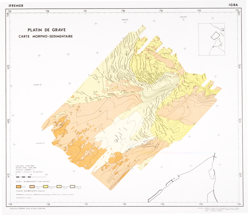
Formations superficielles du platin de Grave, scan géoréférencé
Scan géoréférencé de la carte morpho-sédimentaire du platin de Grave, dans l'embouchure de la Gironde. Edition 1986. Echelle 1/10 000.
Campagne océanographique à l'origine de cette carte :
- BERNE Serge (1984) FASEC-1 cruise, RV Cote D'Aquitaine, https://doi.org/10.17600/84012111
Référence bibliographique : BERNÉ S., BRAUD F., WEBER O. (1986) - Platin de Grave (Gironde), mosaïque sonar latéral, échelle 1/5 000. 2 cartes interprétatives, échelle 1/10 000 et une notice explicative. Ed. Ifremer.
Simple
- Date (Publication)
- 1986-01-01T00:00:00
- Date (Revision)
- 2006-08-01T00:00:00
- Edition
- Edition Ifremer
- Edition date
- 1986-01-01T00:00:00
- Identifier
- FR-330-715-368-00032-FormationsSup_PlatinGrave_Berne_1986_ScanGeoref
- Presentation form
- Digital image
- Credit
- Ifremer / Université de Bordeaux I
- Status
- completed Completed
- Maintenance and update frequency
- Not planned
- Thèmes Sextant
-
- /Cartes scannées/Ifremer/Sédimentologie
- GEMET - INSPIRE themes, version 1.0
-
- Géologie
- external.theme.gemet
-
- fond marin
- sédiment marin
- Theme
-
- formations superficielles
- natures des fonds
- Place
-
- Grave
- Gironde
- Golfe de Gascogne
- Discipline
-
- géophysique
- sédimentologie
- Use limitation
- CC-BY (Creative Commons - Attribution)
- Access constraints
- Other restrictions
- Use constraints
- License
- Other constraints
- Pas de restriction d'accès public
- Other constraints
- Proposition de citation : BERNÉ S., BRAUD F., WEBER O. (1986) - Platin de Grave (Gironde), mosaïque sonar latéral, échelle 1/5 000. 2 cartes interprétatives, échelle 1/10 000 et une notice explicative. Ed. Ifremer.
- Spatial representation type
- grid Grid
- Denominator
- 10000
- Metadata language
- Français
- Character set
- utf8 UTF8
- Topic category
-
- Geoscientific information
- Description
- Période d'acquisition des données
- Begin date
- 1984-06-20T11:30:00
- End date
- 1984-07-30T11:31:00
))
- Reference system identifier
- EPSG / NTF (Paris) / Lambert Centre France (EPSG:27562) / 7.4
- Number of dimensions
- 2
- Dimension name
- Column
- Dimension size
- 5907
- Resolution
- 1.496608 m
- Dimension name
- Row
- Dimension size
- 5133
- Resolution
- 1.504056 m
- Cell geometry
- Area
- Transformation parameter availability
- No
Distributor
- OnLine resource
-
Campagne FASEC-1
(
WWW:LINK
)
Campagne FASEC-1
- OnLine resource
-
FormationsSup_PlatinGrave_Berne_1986_ScanGeoref
(
OGC:WMS
)
Scan géoréférencé
- Protocol
- COPYFILE
- Name
- FormationsSup_PlatinGrave_Berne_1986_ScanGeoref
- Description
- Scan géoréférencé
- Hierarchy level
- Dataset
Completeness omission
Conformance result
- Date (Publication)
- 2007-03-14
- Explanation
- Non évalué
- Pass
- No
- Statement
- 2006 : Carte originale papier scannée et géoréférencée.
- File identifier
- d4d2f910-ba8f-11df-a9b6-005056987263 XML
- Metadata language
- Français
- Character set
- UTF8
- Hierarchy level
- Dataset
- Date stamp
- 2025-12-18T16:28:36.749578Z
- Metadata standard name
- ISO 19115-3 - SEXTANT
- Metadata standard version
- 1.0
Overviews
Spatial extent
Provided by
