 Catalogue PIGMA
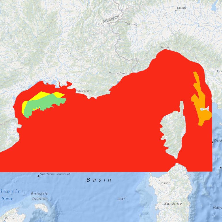
MEDSEA_CH1_Product_3 / Suitability index of a wind farm in the NWMed concerning the environmental resources, the natural barriers, human activities, MPA and fisheries.
Simple
- Date (Creation)
- 2016-11-21
- Identifier
- DOI:10.12770/d7b457aa-1339-482d-8b98-fedae1bc3ce2
- Issue identification
- MEDSEA D2.3.5
- Purpose
- A suitability index of a wind farm in the NW Mediterranean concerning the environmental resources, the natural barriers, human activities, MPA and fisheries
- Credit
- EMODnet Medsea Checkpoint
- Used by challenges
-
- MedSea - CH01 - Windfarm Siting
- Processing level of characteristics
-
- High level analyzed
- Production mode
-
- Delayed
- GEMET - INSPIRE themes, version 1.0
-
- Energy resources
- Theme
-
- Offshore wind energy
- Wind energy site assessment
- Numerical Atmospheric Modeling
- Aggregate Datasetindentifier
- 4e04ad5e-219e-4c54-90a5-7698057c43b2
- Association Type
- Cross reference
- Initiative Type
- upstreamData
- Aggregate Datasetindentifier
- 419534c7-060b-4448-8e96-813a70e31c17
- Association Type
- Cross reference
- Initiative Type
- specification
- Aggregate Datasetindentifier
- a2c54d18-7cd3-4884-9b4a-455f095245b6
- Association Type
- Cross reference
- Initiative Type
- upstreamData
- Aggregate Datasetindentifier
- 693b567a-aa42-4053-8ef9-e225c007ca58
- Association Type
- Cross reference
- Initiative Type
- upstreamData
- Aggregate Datasetindentifier
- 54d0b826-02f0-4273-a79e-dc4b2b0e31e0
- Association Type
- Cross reference
- Initiative Type
- upstreamData
- Aggregate Datasetindentifier
- dfdc5852-929b-4c16-ad82-29645842420e
- Association Type
- Cross reference
- Initiative Type
- upstreamData
- Spatial representation type
- vector Vector
- Metadata language
- English
- Character set
- utf8 UTF8
- Topic category
-
- Oceans
))
- Begin date
- 2001-01-01T00:00:00
- End date
- 2010-12-31T23:59:00 Before
Vertical extent
- Minimum value
- -80
- Maximum value
- 500
- Distribution format
-
-
ESRI Shapefile
()
-
ESRI Shapefile
()
- OnLine resource
-
CH1_product_3
(
OGC:OWS-C
)
Product visualization
- OnLine resource
-
DOI of the product
(
WWW:LINK-1.0-http--metadata-URL
)
DOI of the product
- OnLine resource
-
Access to the website
(
WWW:LINK
)
Access to the website
- Hierarchy level
- datasetComponent
- Begin date
- 2001-01-01T00:00:00
- End date
- 2010-12-31T23:59:00 Before
Vertical extent
- Minimum value
- -80
- Maximum value
- 0
- Other
- MEDSEA_CH1_Product_3_1
- Other
- Environmental ressources for the total suitability index for offshore wind farm sitting
- Other
- Air|Wind strength and direction|Northward wind velocity in the atmosphere|Forecast/Hindcast|Delayed
Completeness omission
- Name of measure
- Horizontal Spatial Coverage
- Measure identification
- AP.1.1
- Measure description
- Horizontal coverage extent of product (eg : surface of the Mediterranean Sea)
Quantitative result
- Value type
- Real
- Value
- 257526.36
Completeness omission
- Name of measure
- Vertical Spatial Coverage
- Measure identification
- AP.1.2
- Measure description
- Vertical coverage extent of product
Quantitative result
- Value type
- Real
- Value
- 80
Completeness omission
- Name of measure
- Temporal Coverage
- Measure identification
- AP.1.3
- Measure description
- Temporal coverage extent of product
Quantitative result
- Value type
- Integer
- Value
- 3652
Conceptual consistency
- Name of measure
- Number of Characteristics
- Measure identification
- AP.2.1
- Measure description
- Number of characteristics in product
Quantitative result
- Value type
- Integer
- Value
- 1
Thematic classification correctness
- Name of measure
- Horizontal resolution
- Measure identification
- AP.3.1
- Measure description
- Horizontal mesh size or equivalent value for the given scale of product (eg 50m for 1/50 000)
Quantitative result
- Value type
- Integer
- Value
- 5000
Thematic classification correctness
- Name of measure
- Vertical resolution
- Measure identification
- AP.3.2
- Measure description
- Average vertical sampling
Quantitative result
- Value type
- Real
- Value
- 3
gmd:DQ_DescriptiveResult
- Date / Time
- 2016-11-28T00:00:00
Thematic classification correctness
- Name of measure
- Temporal resolution
- Measure identification
- AP.3.3
- Measure description
- Temporal sampling interval of product
Quantitative result
- Value type
- Real
Quantitative attribute accuracy
- Name of measure
- Thematic accuracy
- Measure identification
- AP.3.4
- Measure description
- Percentage error of the product and description of error concept for the product (100 words max) provided by expert
Quantitative result
- Value type
- Percentage
- Value
- 20
Temporal validity
- Name of measure
- Temporal validity
- Measure identification
- AP.4.1
- Measure description
- Max elapsed time between last input data records update and product creation date
Quantitative result
- Value type
- Integer
- Value
- 1095
- Hierarchy level
- datasetComponent
- Begin date
- 2001-01-01T00:00:00
- End date
- 2010-12-31T23:59:00 Before
Vertical extent
- Minimum value
- 0
- Maximum value
- 500
- Other
- MEDSEA_CH1_Product_3_2
- Other
- Local constrainsts for the establishment of the suitability index : human activities, MPA and fisheries, seafloor depth and lithology.
- Other
- Human activities|Administrative units||High level analyzed|Delayed
- Other
- Human activities|Transport activity||High level analyzed|Delayed
- Other
- Seabed - Riverbed|Bathymetry and Elevation|Sea-floor depth (below mean sea level) {bathymetric depth}|High level analyzed|Delayed
- Other
- Seabed - Riverbed|Sedimentary structure|Description of lithology of sediment by visual estimation|Observation (raw, QC)|Delayed
Completeness omission
- Name of measure
- Horizontal Spatial Coverage
- Measure identification
- AP.1.1
- Measure description
- Horizontal coverage extent of product (eg : surface of the Mediterranean Sea)
Quantitative result
- Value type
- Real
- Value
- 257526.36
Completeness omission
- Name of measure
- Vertical Spatial Coverage
- Measure identification
- AP.1.2
- Measure description
- Vertical coverage extent of product
Quantitative result
- Value type
- Real
- Value
- 3000
Completeness omission
- Name of measure
- Temporal Coverage
- Measure identification
- AP.1.3
- Measure description
- Temporal coverage extent of product
Quantitative result
- Value type
- Integer
- Value
- 3652
Conceptual consistency
- Name of measure
- Number of Characteristics
- Measure identification
- AP.2.1
- Measure description
- Number of characteristics in product
Quantitative result
- Value type
- Integer
- Value
- 4
Thematic classification correctness
- Name of measure
- Horizontal resolution
- Measure identification
- AP.3.1
- Measure description
- Horizontal mesh size or equivalent value for the given scale of product (eg 50m for 1/50 000)
Quantitative result
- Value type
- Integer
- Value
- 1000
Thematic classification correctness
- Name of measure
- Vertical resolution
- Measure identification
- AP.3.2
- Measure description
- Average vertical sampling
Quantitative result
- Value type
- Real
gmd:DQ_DescriptiveResult
- Date / Time
- 2016-09-21T00:00:00
Thematic classification correctness
- Name of measure
- Temporal resolution
- Measure identification
- AP.3.3
- Measure description
- Temporal sampling interval of product
Quantitative result
- Value type
- Real
Quantitative attribute accuracy
- Name of measure
- Thematic accuracy
- Measure identification
- AP.3.4
- Measure description
- Percentage error of the product and description of error concept for the product (100 words max) provided by expert
Quantitative result
- Value type
- Percentage
- Value
- 20
Temporal validity
- Name of measure
- Temporal validity
- Measure identification
- AP.4.1
- Measure description
- Max elapsed time between last input data records update and product creation date
Quantitative result
- Value type
- Integer
- Value
- 3652
Completeness omission
- Name of measure
- Horizontal spatial coverage error
- Measure identification
- P.APE.1.1
- Measure description
-
Percentage to which the extent of the horizontal
spatial coverage of TPD is not compliant with the DPS extent in km**2(TDP_AP_1_1 - DPS_AP_1_1)*100/DPS_AP_1_1
Quantitative result
- Value type
- Percentage
- Value
- 0
Completeness omission
- Name of measure
- Vertical spatial coverage error
- Measure identification
- P.APE.1.2
- Measure description
-
Percentage to which the extent of the vertical spatial coverage of TPD is not compliant with the DPS extent in
metres.(TDP_AP_1_2 - DPS_AP_1_2)*100/DPS_AP_1_2
Quantitative result
- Value type
- Percentage
- Value
- -55.55555555555556
Completeness omission
- Name of measure
- Temporal coverage error
- Measure identification
- P.APE.1.3
- Measure description
-
Percentage to which the extent of the temporal coverage of TPD is not compliant with the DPS extent in
days.(TDP_AP_1_3 - DPS_AP_1_3)*100/DPS_AP_1_3
Quantitative result
- Value type
- Percentage
- Value
- 0
Conceptual consistency
- Name of measure
- Thematic content error
- Measure identification
- P.APE.2.1
- Measure description
-
Percentage
of completeness/Incompleteness of the number of characteristcs with respect to the list in DPS(TDP_AP_2_1 - DPS_AP_2_1)*100/DPS_AP_2_1
Quantitative result
- Value type
- Percentage
- Value
- 0
Thematic classification correctness
- Name of measure
- Horizontal resolution error
- Measure identification
- P.APE.3.1
- Measure description
-
Percentage to which the product averaged horizontal mesh size or horizontal scale is not compliant with the DPS
averaged mesh size or horizontal scale(DPS_AP_3_1 - TDP_AP_3_1)*100/DPS_AP_3_1
Quantitative result
- Value type
- Percentage
- Value
- 0
Thematic classification correctness
- Name of measure
- Vertical resolution error
- Measure identification
- P.APE.3.2
- Measure description
-
Percentage to which the product averaged vertical mesh size or vertical scale is not compliant with the DPS
averaged mesh size or vertical scale(DPS_AP_3_2 - TDP_AP_3_2)*100/DPS_AP_3_2
Quantitative result
- Value type
- Percentage
- Value
- 92.5
Thematic classification correctness
- Name of measure
- Temporal sampling interval error
- Measure identification
- P.APE.3.3
- Measure description
-
Percentage to which the product temporal sampling interval is not compliant with the one defined in DPS
(percentage to be extracted from text of AP.3.3 measure)(DPS_AP_3_3 - TDP_AP_3_3)*100/DPS_AP_3_3
Quantitative result
- Value type
- Percentage
Quantitative attribute accuracy
- Name of measure
- Thematic accuracy errror
- Measure identification
- P.APE.3.4
- Measure description
-
Compliance with the value domain of
the accuracy defined in DPS (% extracted from thematic accuracy description)TDP_AP_3_4
Quantitative result
- Value type
- Percentage
- Value
- 20
Temporal validity
- Name of measure
- Temporal validity error
- Measure identification
- P.APE.4.1
- Measure description
-
Percentage to which the elapsed time of the product is not compliant with the max elapsed time specified in
DPS.(DPS_AP_4_1 - TDP_AP_4_1)*100/DPS_AP_4_1
Quantitative result
- Value type
- Percentage
- Value
- 0
Completeness omission
- Name of measure
- Horizontal spatial coverage error
- Measure identification
- P.APE.1.1
- Measure description
-
Percentage to which the extent of the horizontal
spatial coverage of TPD is not compliant with the DPS extent in km**2(TDP_AP_1_1 - DPS_AP_1_1)*100/DPS_AP_1_1
Quantitative result
- Value type
- Percentage
- Value
- 0
Completeness omission
- Name of measure
- Vertical spatial coverage error
- Measure identification
- P.APE.1.2
- Measure description
-
Percentage to which the extent of the vertical spatial coverage of TPD is not compliant with the DPS extent in
metres.(TDP_AP_1_2 - DPS_AP_1_2)*100/DPS_AP_1_2
Quantitative result
- Value type
- Percentage
- Value
- 500
Completeness omission
- Name of measure
- Temporal coverage error
- Measure identification
- P.APE.1.3
- Measure description
-
Percentage to which the extent of the temporal coverage of TPD is not compliant with the DPS extent in
days.(TDP_AP_1_3 - DPS_AP_1_3)*100/DPS_AP_1_3
Quantitative result
- Value type
- Percentage
- Value
- 0
Conceptual consistency
- Name of measure
- Thematic content error
- Measure identification
- P.APE.2.1
- Measure description
-
Percentage
of completeness/Incompleteness of the number of characteristcs with respect to the list in DPS(TDP_AP_2_1 - DPS_AP_2_1)*100/DPS_AP_2_1
Quantitative result
- Value type
- Percentage
- Value
- 0
Thematic classification correctness
- Name of measure
- Horizontal resolution error
- Measure identification
- P.APE.3.1
- Measure description
-
Percentage to which the product averaged horizontal mesh size or horizontal scale is not compliant with the DPS
averaged mesh size or horizontal scale(DPS_AP_3_1 - TDP_AP_3_1)*100/DPS_AP_3_1
Quantitative result
- Value type
- Percentage
- Value
- 0
Thematic classification correctness
- Name of measure
- Vertical resolution error
- Measure identification
- P.APE.3.2
- Measure description
-
Percentage to which the product averaged vertical mesh size or vertical scale is not compliant with the DPS
averaged mesh size or vertical scale(DPS_AP_3_2 - TDP_AP_3_2)*100/DPS_AP_3_2
Quantitative result
- Value type
- Percentage
Thematic classification correctness
- Name of measure
- Temporal sampling interval error
- Measure identification
- P.APE.3.3
- Measure description
-
Percentage to which the product temporal sampling interval is not compliant with the one defined in DPS
(percentage to be extracted from text of AP.3.3 measure)(DPS_AP_3_3 - TDP_AP_3_3)*100/DPS_AP_3_3
Quantitative result
- Value type
- Percentage
Quantitative attribute accuracy
- Name of measure
- Thematic accuracy errror
- Measure identification
- P.APE.3.4
- Measure description
-
Compliance with the value domain of
the accuracy defined in DPS (% extracted from thematic accuracy description)TDP_AP_3_4
Quantitative result
- Value type
- Percentage
- Value
- 20
Temporal validity
- Name of measure
- Temporal validity error
- Measure identification
- P.APE.4.1
- Measure description
-
Percentage to which the elapsed time of the product is not compliant with the max elapsed time specified in
DPS.(DPS_AP_4_1 - TDP_AP_4_1)*100/DPS_AP_4_1
Quantitative result
- Value type
- Percentage
- Value
- 0
- File identifier
- d7b457aa-1339-482d-8b98-fedae1bc3ce2 XML
- Metadata language
- English
- Character set
- UTF8
- Hierarchy level
- Dataset
- Date stamp
- 2025-01-28T09:12:39.141319Z
- Metadata standard name
- ISO 19115-3 - Emodnet Checkpoint - Targeted Data Product
Overviews
Spatial extent
Provided by
